Home / Editor's Pick /

Spotted in the UK: Incredible display of aurora

10:01
28 September 2022

Spotted in the UK
Incredible display of aurora

Settings for external content

Privacy Policy

On September 26th, parts of Canada, North America, Scandinavia and even the UK were blessed by an un expected northern lights display.

People were caught by surprise on Monday night when they went outdoors to photograph Jupiter, but instead captured a jaw-dropping display of aurora overhead.

NOAA's Space Center predicted visibility as far south as 50 degrees N, with people capturing the aurora as far south as Bulmer in North Yorkshire, at about 54 degrees N.

This was due to a sudden spike in solar activity, the result of a CME (coronal mass ejection). It consequently disturbed our magnetic field, producing the brilliant display of aurora.

Aurora can be difficult to spot with the naked eye, but beautifully photographed with a few handy tips:

  • Long exposure is critical; often around 12-20 seconds, though some may need nearer to 30 seconds
  • Use a tripod to keep your camera still
  • Avoid being around external light sources
  • A fast aperture of minimum f4, but ideally f2.8
  • The higher the ISO, the more light you capture, but the grainier the shot
  • Clear skies are needed - check our WeatherRadar for cloud cover

The spectacular colours can be attributed to the gases present in the atmosphere. Green is associated with oxygen, whilst purple, blue, or pink are typical with nitrogen.

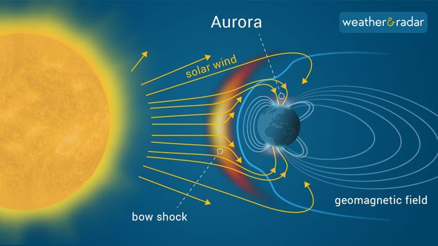
Auroras are caused when the sun ejects significant amounts of particles towards Earth, during periods of heightened solar activity.

This material then interacts with the Earth's magnetic fields and the gases in our atmosphere, producing the display.

aurora infographic

If you've ever managed to capture this breathtaking phenomenon, send in your photos to our uploader here.

Weather & Radar editorial team
More on the topic
Split image showing a low-tide estuary at sunset on the left with concrete blocks, boats, and pastel sky, and a bright full moon on the right glowing through thin clouds above dark tree silhouettes, divided by a curved white line.
Sunday, 7 December 2025

Your weather - Your shots

Winter weather snaps and a supermoon too
Temperature map showing maximum values at the beginning of next week and wind radar showing a storm system over the Atlantic that is directing mild air towards Europe
Thursday, 4 December 2025

Gusty in the UK & Ireland

Storms will soon bring spring air
Split image showing a snowy Christmas market on the left and a UK weather map on the right with pink zones indicating widespread snowfall over Liverpool, Manchester, Birmingham, and Newcastle, plus white snow icons.
Monday, 8 December 2025

Everyone wants to know...

How likely is a White Christmas?
All weather news
This might also interest you
Sunday, 24 August 2025

Your weather - Your shots

Mammatus clouds widely spotted
Split weather map showing the UK and Ireland. The left side illustrates strong winds circulating around a low-pressure system, with gusts of 20–30 mph highlighted in orange and yellow. The right side shows radar imagery with widespread blue rain bands and patches of thunderstorms, especially over northern England and Scotland.
Thursday, 28 August 2025

Breakfast brief

Remaining widely unsettled
Monday, 25 August 2025

Bank holiday outlook

Warm day turning gusty in places
All articles
Weather & Radar

Weather & Radar is also available on

Google Play StoreApp Store

Company

Contact us Privacy Policy Legal info Accessibility statement

Services

Uploader

Socials

facebooktwittertikToklinkList