Home
Weather London
WeatherRadar
RainfallRadar
TemperatureRadar
WindRadar
LightningRadar
Weather News
Editor's Pick
Discover the app
Weather widget
Contact us
Apps
Career
    Home / Editor's Pick /

    Solomon Islands and Fiji: Cyclones threaten South Pacific islands

10:09
6 April 2026

Solomon Islands and Fiji
Cyclones threaten South Pacific islands

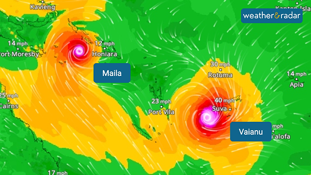
WindRadar: Two cyclones are currently threatening the South Sea islands off the coast of Australia.

On the South Sea islands east of Australia: between the Fiji Islands and the neighbouring state of Vanuatu, Cyclone Vaianu is sweeping across the South Pacific.

Meanwhile, Cyclone Maila is making its way near the Solomon Islands. Both storms are accompanied by gale-force winds and torrential rain.

In Fiji, the authorities have issued warnings of gusts of wind, flash floods and flooding. Schools and universities remain closed. Low-lying areas are particularly at risk. Vaianu is expected to strengthen into a Category 3 cyclone during the course of Tuesday.

Although the eye of the storm will pass over the sea between Fiji and Vanuatu, the authorities remain on high alert. It was only in 2020 that the devastating Cyclone Yasu caused severe damage to the island nation and claimed several lives.

Cyclone Maila off the Solomon Islands, on the other hand, shows little sign of moving for the time being. However, it is expected to move westwards towards the Australian coast in the coming days.

Jürgen Vollmer
More on the topic
New heatwave in southern Europe. Up to 45 degrees in Spain. . . Tuesday, 21 July 2026
Split temperature map showing extreme heat across Spain on the left and Greece on the right, with temperatures reaching 44°C near Murcia, around 40°C in parts of Greece, and a large thermometer icon highlighting dangerous heat.
Tuesday, 21 July 2026

Up to 45 degrees in Spain

New heatwave in southern Europe
Drought for North Wales and Upper Severn. 2% of average rainfall. . . Thursday, 23 July 2026
Split image showing a July rainfall anomaly map of Europe on the left with below-average rainfall across the UK, Ireland, and much of western and central Europe, and an active moorland wildfire on the right producing flames and thick smoke near homes.
Thursday, 23 July 2026

2% of average rainfall

Drought for North Wales and Upper Severn
Heat becoming a bigger factor in drought. New study. . . Thursday, 23 July 2026
A hand holds dry, dusty earth above a parched field. The ground is cracked and covered with plant debris – a sign of prolonged drought.
Thursday, 23 July 2026

New study

Heat becoming a bigger factor in drought
All weather news
This might also interest you
Flooding, gales, and heavy snow. Storm Chandra. . . Tuesday, 27 January 2026
Split image showing aerial flooding in a town with muddy water covering roads on the left, and a rural road on the right blocked by heavy snowfall with vans stopped and a person walking in snow.
Tuesday, 27 January 2026

Storm Chandra

Flooding, gales, and heavy snow
Storm Chandra makes impact. Severe gales & heavy rain. . . Tuesday, 27 January 2026
Split image showing strong winds over the UK on a forecast map and widespread rain and snow on a weather radar map.
Tuesday, 27 January 2026

Severe gales & heavy rain

Storm Chandra makes impact
Seasonal warmth between spring thunder. Your weather - Your shots. . . Sunday, 19 April 2026
Split image showing coastal sunset with layered lenticular clouds over rooftops and palm trees on the left, and a green valley with river and hills under soft daylight on the right.
Sunday, 19 April 2026

Your weather - Your shots

Seasonal warmth between spring thunder
All articles
Weather & Radar

Weather & Radar is also available on

Google Play StoreApp Store

Company

Contact us Privacy Policy Legal info Accessibility statement

Services

Uploader

Socials

facebooktwittertikToklinkList