Home
Weather London
WeatherRadar
RainfallRadar
TemperatureRadar
WindRadar
LightningRadar
Weather News
Editor's Pick
Discover the app
Weather widget
Contact us
Apps
Career
    Home / Editor's Pick /

    Severe weather in southern Europe: thunderstorms, hail and heavy rain on the way

11:14
9 September 2026

Thunderstorms & heavy rain
Severe weather in southern Europe

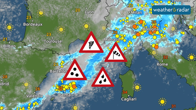
There’s a storm brewing in parts of southern Europe today. From this afternoon onwards, thunderstorms, some becoming severe, will be moving in from the western Mediterranean as far as northern Italy. Anyone currently travelling in these areas should be particularly careful:

  • Northern Italy
  • Mallorca, Menorca and Ibiza
  • Sardinia
  • Corsica

If you’re on holiday there or out and about, keep an eye on the sky and the WeatherRadar. First of all, so-called supercells form. These are particularly powerful thunderstorms that can bring large hailstones, torrential rain, heavy gusts of wind and, in isolated cases, even tornadoes.

WeatherRadar Forecast for today.

Later, the thunderstorms will merge to form larger thunderstorm systems. The main focus will then be on gales and, in some cases, prolonged heavy rain.

Heavy rainfall in Croatia

On Thursday and Friday, the focus of the severe weather will shift to the Adriatic. Particularly around Trieste and along the Croatian coast, 100 to 200 mm, and locally higher amounts, could fall within a short space of time.

This can cause streams and small rivers to rise very quickly. It’s best to avoid bodies of water during this time. By the weekend, the weather conditions will gradually ease off again.

Weather & Radar editorial team

More on the topic

Overnight impacts as Austen hits. Power cuts, travel issues. . . Friday, 23 October 2026
Split image showing floodwater surging beneath a railway bridge at night and a wind map with low pressure over the English Channel and 60 mph near Brest.
Friday, 23 October 2026

Power cuts, travel issues

Overnight impacts as Austen hits
Severe weather in the south of France. Holiday spots affected. . . Monday, 19 October 2026
A severe weather warning for heavy rain has been issued for the south of France.
Monday, 19 October 2026

Holiday spots affected

Severe weather in the south of France
Preparing for the storms. What to do now. . . Thursday, 22 October 2026
Split image showing Storm Austen winds up to 65 mph near Brest and 55 mph near Plymouth, alongside fallen tree branches on a cordoned-off park path.
Thursday, 22 October 2026

What to do now

Preparing for the storms
All weather news

This might also interest you

Storm Chandra makes impact. Severe gales & heavy rain. . . Tuesday, 27 January 2026
Split image showing strong winds over the UK on a forecast map and widespread rain and snow on a weather radar map.
Tuesday, 27 January 2026

Severe gales & heavy rain

Storm Chandra makes impact
Long-term trends need a pinch of salt. 40 °C in July?. . . Tuesday, 30 June 2026
Temperature radar of 2022 heatwave where the all-time temperature record in the UK was set. Warning symbol overlain.
Tuesday, 30 June 2026

40 °C in July?

Long-term trends need a pinch of salt
Historic Storm Éowyn arrives. On this day.... . . Saturday, 24 January 2026
Split image showing a person in a yellow jacket struggling against strong winds and heavy rain on a street at night on the left, and an Irish wind forecast map on the right with red and purple shading, gusts up to 75 mph, and a wind warning icon, divided by a curved white line.
Saturday, 24 January 2026

On this day...

Historic Storm Éowyn arrives
All articles
Weather & Radar

Weather & Radar is also available on

Google Play StoreApp Store

Company

Contact us Privacy Policy Legal info Accessibility statement

Services

Uploader

Socials

facebooktwittertikToklinkList