Home
Weather London
WeatherRadar
RainfallRadar
TemperatureRadar
WindRadar
LightningRadar
Weather News
Editor's Pick
Discover the app
Weather widget
Contact us
Apps
Career
    Home / Editor's Pick /

    Peaking Wednesday - Fourth heatwave of the year

08:41
28 July 2026

Peaking Wednesday
Fourth heatwave of the year

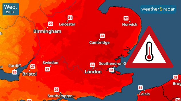
Temperatures in the latest heatwave peak on Wednesday.

The fourth heatwave of the year is underway, peaking on Wednesday but much shorter lasting than the previous waves.

Local temperatures could reach highs of 34°C in south-east England and more widely in the high-20s to low-30s across much of England.

Yellow heat-health alerts extend across western parts of England, while amber alerts cover the east. The UK Health Security Agency issue these alerts in conjunction with the Met Office to guide pressure on health services due to elevated temperatures.

Despite the heat, temperatures will already begin to drop from Thursday.

The latest heatwave reignites worries over wildfires and drought. The UK has seen 20% of its average July rainfall this year, just 5% in England, and a mere 1% in southern England.

In Scotland, evacuations took place over the weekend due to a severe wildfire in the Cairngorms while separate fires in Derbyshire and Greater Manchester have burned for weeks now.

Ryan Hathaway
More on the topic
Cheshire Gap produces shower funnel. Local phenomenon. . . Wednesday, 9 September 2026
Weather map showing showers moving southeast from Liverpool toward Birmingham, driven by Cheshire Gap convergence across central England.
Wednesday, 9 September 2026

Local phenomenon

Cheshire Gap produces shower funnel
Hurricane Lowell threatens Hawaii. Gales and flash floods. . . Tuesday, 8 September 2026
WindRadar showing Hurricane Lowell north-west of Hawaii and its well-defined storm centre.
Tuesday, 8 September 2026

Gales and flash floods

Hurricane Lowell threatens Hawaii
Severe weather in the Mediterranean. Is a medicane on the way?. . . Monday, 14 September 2026
A weather map shows a powerful low-pressure system over the Mediterranean, with warning symbols for storms and heavy rain.
Monday, 14 September 2026

Is a medicane on the way?

Severe weather in the Mediterranean
All weather news
This might also interest you
Historic Storm Éowyn arrives. On this day.... . . Saturday, 24 January 2026
Split image showing a person in a yellow jacket struggling against strong winds and heavy rain on a street at night on the left, and an Irish wind forecast map on the right with red and purple shading, gusts up to 75 mph, and a wind warning icon, divided by a curved white line.
Saturday, 24 January 2026

On this day...

Historic Storm Éowyn arrives
Seasonal warmth between spring thunder. Your weather - Your shots. . . Sunday, 19 April 2026
Split image showing coastal sunset with layered lenticular clouds over rooftops and palm trees on the left, and a green valley with river and hills under soft daylight on the right.
Sunday, 19 April 2026

Your weather - Your shots

Seasonal warmth between spring thunder
Bright and warm conditions take hold. Spring-like outlook. . . Thursday, 23 April 2026
Split UK map showing warm temperatures up to 21 degrees in orange on the left and clear sunny conditions with temperatures from 12 to 18 degrees on the right, with sun icons across the country.
Thursday, 23 April 2026

Spring-like outlook

Bright and warm conditions take hold
All articles
Weather & Radar

Weather & Radar is also available on

Google Play StoreApp Store

Company

Contact us Privacy Policy Legal info Accessibility statement

Services

Uploader

Socials

facebooktwittertikToklinkList