Home
Weather London
WeatherRadar
RainfallRadar
TemperatureRadar
WindRadar
LightningRadar
Weather News
Editor's Pick
Discover the app
Weather widget
Contact us
Apps
Career
    Home / Editor's Pick /

    Over 50 degree split – enormous temperature contrasts in Europe

08:36
6 February 2026

Over 50 degree split
Enormous temperature contrasts in Europe

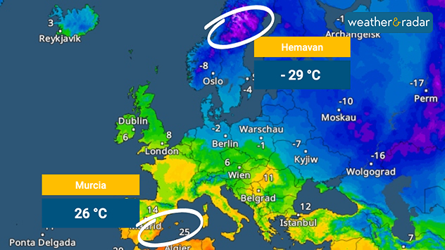
Temperature map of Europe showing extreme cold in northern Scandinavia with −29 °C at Hemavan and much warmer conditions in southern Spain with 26 °C at Murcia, highlighted by colour gradients and labels.
At 26 degrees, it was over 50 degrees warmer in Murcia, Spain, on Thursday afternoon than in northern Sweden.

Winter and spring are currently colliding in Europe in a way rarely seen before.

While temperatures in northern Sweden reached a freezing minus 29 degrees on Thursday, Murcia in Spain recorded its first summer day with temperatures of plus 26 degrees.

Although temperature differences in Europe are usually greatest in spring, they rarely exceed 50 degrees. A first summer day in early February is very unusual, even for southern Europe.

However, the cause of the unusual heat in southern Spain was not particularly beautiful spring weather, but quite the opposite: a storm

The wind field from storm Leonardo swept across the Iberian Peninsula and descended from the slopes of the coastal mountains as a strong foehn storm. Despite the high temperatures, the weather there was anything but pleasant.

Flooding in Spain and Portugalread also
Jürgen Vollmer
More on the topic
Stronger winds make a return. Low pressure influence. . . Tuesday, 4 August 2026
Wind forecast map of the UK and Ireland showing a low-pressure system north of Scotland, a windsock icon highlighting blustery conditions, and widespread winds of 30–40 mph across the British Isles, with the strongest winds around Ireland and northern Britain.
Tuesday, 4 August 2026

Low pressure influence

Stronger winds make a return
Japan braces itself for Typhoon Dolphin. Landslides feared. . . Wednesday, 5 August 2026
Weather map showing a typhoon south of Japan. The centre of the storm is over the Pacific and is moving westwards. The coloured wind fields indicate its high intensity.
Wednesday, 5 August 2026

Landslides feared

Japan braces itself for Typhoon Dolphin
Vibrant skies for the last week of July. Your weather - Your shots. . . Sunday, 2 August 2026
Split image showing a golden-orange countryside sunset with silhouetted trees and birds on the left, and glowing blue-white noctilucent clouds rippling across the twilight sky above trees and a lake on the right.
Sunday, 2 August 2026

Your weather - Your shots

Vibrant skies for the last week of July
All weather news
This might also interest you
Historic Storm Éowyn arrives. On this day.... . . Saturday, 24 January 2026
Split image showing a person in a yellow jacket struggling against strong winds and heavy rain on a street at night on the left, and an Irish wind forecast map on the right with red and purple shading, gusts up to 75 mph, and a wind warning icon, divided by a curved white line.
Saturday, 24 January 2026

On this day...

Historic Storm Éowyn arrives
Seasonal warmth between spring thunder. Your weather - Your shots. . . Sunday, 19 April 2026
Split image showing coastal sunset with layered lenticular clouds over rooftops and palm trees on the left, and a green valley with river and hills under soft daylight on the right.
Sunday, 19 April 2026

Your weather - Your shots

Seasonal warmth between spring thunder
Turbulent weather in the Canary Islands. Storm and rain. . . Friday, 12 December 2025
Weather graphic showing rain and wind fields over the Canary Islands and a central warning symbol.
Friday, 12 December 2025

Storm and rain

Turbulent weather in the Canary Islands
All articles
Weather & Radar

Weather & Radar is also available on

Google Play StoreApp Store

Company

Contact us Privacy Policy Legal info Accessibility statement

Services

Uploader

Socials

facebooktwittertikToklinkList