Home
Weather London
WeatherRadar
RainfallRadar
TemperatureRadar
WindRadar
LightningRadar
Weather News
Editor's Pick
Discover the app
Weather widget
Contact us
Apps
Career
    Home / Editor's Pick /

    Fresh storm front - Severe flooding in Spain and Portugal

07:56
5 February 2026

Fresh storm front
Severe flooding in Spain and Portugal

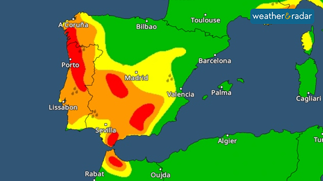
Severe weather warnings for heavy rain are in place for large parts of Portugal and Spain.

Extremely heavy rain has caused flooding in parts of Spain and Portugal. In Andalusia, more than 3,000 people had to leave their homes.

Storm Leonardo mainly affected the region of Andalusia. After hours of heavy rain, numerous rivers burst their banks, triggering landslides, and flooding.

In the municipality of Ubrique in the Andalusian province of Cádiz, the torrential rain even triggered a rockslide. A building and a car were damaged, but fortunately no one was injured.

Privacy Policy

Previously, enormous amounts of rain, nearly 300 mm, had fallen in the region of southern Spain, already amounting to around half of last year's total rainfall.

As the WeatherRadar shows, further rainfall is on the way. However, as the ground is now saturated, it cannot absorb any more rainwater. Therefore, there is no sign of the flood situation easing in the affected regions for the time being.

In addition to Andalusia, parts of Portugal have also been affected by the stormy rainfall caused by the Leonardo low-pressure system.

There will also be very strong winds with storm gusts from the Atlantic to the Balearic Islands. Metre-high waves are also expected in the Mediterranean.

Weather & Radar editorial team

More on the topic

Stormy winds finally easing. By the end of the week. . . Tuesday, 27 October 2026
Split wind maps showing winds of 25–40 mph across the UK and Ireland easing to 7–15 mph, with a white arrow indicating the change.
Tuesday, 27 October 2026

By the end of the week

Stormy winds finally easing
Wettest week in England for two years. Stormy assistance. . . Thursday, 29 October 2026
Weather map for Saturday 24.10 showing a swirling Atlantic low, Storm Boelo, west of Scotland and widespread blue rain bands across the UK, Ireland and northern France.
Thursday, 29 October 2026

Stormy assistance

Wettest week in England for two years
Staying fairly blustery across Ireland. Autumn greetings. . . Thursday, 29 October 2026
Wind map showing 35 mph winds near Galway and Cork, 25 mph near Dublin and Belfast, and lighter winds across western Britain, with a windsock symbol.
Thursday, 29 October 2026

Autumn greetings

Staying fairly blustery across Ireland
All weather news

This might also interest you

Bright and warm conditions take hold. Spring-like outlook. . . Thursday, 23 April 2026
Split UK map showing warm temperatures up to 21 degrees in orange on the left and clear sunny conditions with temperatures from 12 to 18 degrees on the right, with sun icons across the country.
Thursday, 23 April 2026

Spring-like outlook

Bright and warm conditions take hold
A frozen start to the weekend. Icy conditions. . . Friday, 13 February 2026
UK temperature map dated 14.02 showing widespread subzero values in blue shading, with readings such as −4 in Glasgow, −3 in Dublin, and −2 in London, alongside a blue thermometer icon.
Friday, 13 February 2026

Icy conditions

A frozen start to the weekend
Super Typhoon Bavi threatens Taiwan. Up to 1,000 mm of rain. . . Wednesday, 8 July 2026
The image shows an intense tropical cyclone over the western Pacific, east of Taiwan and the Philippines. The centre of the system is depicted as a light purple and white vortex with a clearly visible eye, surrounded by a ring of red and orange areas indicating the strongest wind speeds. A white arrow marks the typhoon’s predicted track towards the north-west, in the direction of Taiwan. To the west of the storm lie the Philippines, with the cities of Manila and Cebu; to the north of these lies Taiwan, with Taipei. Further west, the Chinese coast, including Hong Kong, and parts of Vietnam can be seen. The coloured wind map shows predominantly green areas outside the storm’s core, indicating significantly weaker winds. White streamlines illustrate the typhoon’s anti-clockwise circulation in the Northern Hemisphere. The highest wind speeds are concentrated around the eye of the cyclone.
Wednesday, 8 July 2026

Up to 1,000 mm of rain

Super Typhoon Bavi threatens Taiwan
All articles
Weather & Radar

Weather & Radar is also available on

Google Play StoreApp Store

Company

Contact us Privacy Policy Legal info Accessibility statement

Services

Uploader

Socials

facebooktwittertikToklinkList