Home
Weather London
WeatherRadar
RainfallRadar
TemperatureRadar
WindRadar
LightningRadar
Weather News
Editor's Pick
Discover the app
Weather widget
Contact us
Apps
Career
    Home / Editor's Pick /

    Omega block - Weather conditions in Europe are changing

15:20
21 May 2026

Omega block
The weather in Europe is changing

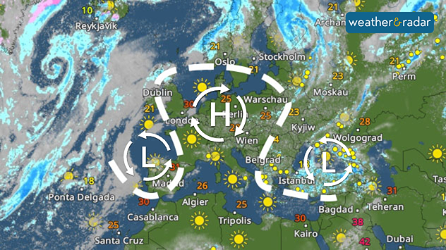
A fairly stable high-pressure system is currently building up over large parts of Europe – flanked by two low-pressure systems to the east and west.

On the weather map, the whole pattern looks like the Greek letter omega, which is why it is known as the "Omega block".

Weather map of Europe showing a high-pressure system over Central Europe, low-pressure systems over the Atlantic and Turkey, numerous sun symbols, and temperatures ranging from 4 to over 40 degrees.
WeatherRadar for Sunday

In terms of the weather, this means that large parts of Europe will be sunny, dry and very warm.

Temperatures are set to reach 30 degrees in Rome, Paris, and London, whilst Berlin and Warsaw will also get a taste of summer with temperatures of around 25 degrees.

The situation is quite different, however, from the Balkans to Turkey: there, one low-pressure system is bringing changeable weather with frequent showers and thunderstorms, some of which are accompanied by heavy rain.

In north-western Spain and Portugal, the other low-pressure system is bringing occasional showers.

Did you know?

The Omega weather pattern is also known as a "blocking high-pressure system" because it blocks the path of Atlantic rain fronts into Central Europe.

Verena Leyendecker
More on the topic
Drought across large parts of Europe. High fire risk. . . Monday, 20 July 2026
Split image showing a Europe rainfall anomaly map on the left with widespread dry conditions across much of the continent, and a cracked, parched field on the right alongside a wildfire warning symbol highlighting elevated fire risk.
Monday, 20 July 2026

High fire risk

Drought across large parts of Europe
Drought for North Wales and Upper Severn. 2% of average rainfall. . . Thursday, 23 July 2026
Split image showing a July rainfall anomaly map of Europe on the left with below-average rainfall across the UK, Ireland, and much of western and central Europe, and an active moorland wildfire on the right producing flames and thick smoke near homes.
Thursday, 23 July 2026

2% of average rainfall

Drought for North Wales and Upper Severn
Rain returns to end dry spell in places. Jet stream delivery. . . Thursday, 23 July 2026
Split weather graphic showing widespread showers across the UK and Ireland on the left, and a wind forecast map on the right with a windsock icon and gusts of 25 to 35 mph, highlighting breezy conditions across the two countries.
Thursday, 23 July 2026

Jet stream delivery

Rain returns to end dry spell in places
All weather news
This might also interest you
New records for England and Wales. Broken again tomorrow?. . . Thursday, 25 June 2026
Temperature map of southwest Britain on 25.06 showing extreme heat across southern Wales and southwest England, with Bute Park in Cardiff highlighted at 34.2°C and Yeovilton at 36.4°C amid widespread deep red heat zones.
Thursday, 25 June 2026

Broken again tomorrow?

New records for England and Wales
Long-term trends need a pinch of salt. 40 °C in July?. . . Tuesday, 30 June 2026
Temperature radar of 2022 heatwave where the all-time temperature record in the UK was set. Warning symbol overlain.
Tuesday, 30 June 2026

40 °C in July?

Long-term trends need a pinch of salt
Storm Chandra makes impact. Severe gales & heavy rain. . . Tuesday, 27 January 2026
Split image showing strong winds over the UK on a forecast map and widespread rain and snow on a weather radar map.
Tuesday, 27 January 2026

Severe gales & heavy rain

Storm Chandra makes impact
All articles
Weather & Radar

Weather & Radar is also available on

Google Play StoreApp Store

Company

Contact us Privacy Policy Legal info Accessibility statement

Services

Uploader

Socials

facebooktwittertikToklinkList