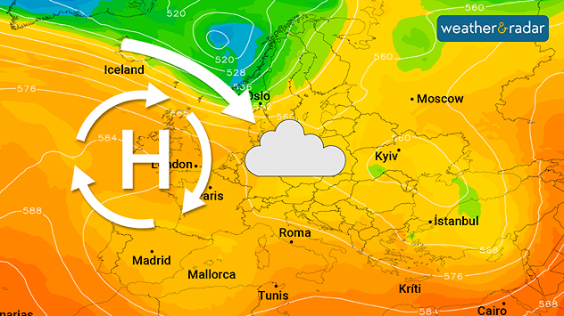
Home
Weather London
WeatherRadar
RainfallRadar
TemperatureRadar
WindRadar
LightningRadar
Weather News
Editor's Pick
Discover the app
Weather widget
Contact us
Apps
Career
    Home / Editor's Pick /

    Omega block: Pressure over UK shapes Europe's weather

09:00
8 October 2025

Omega block
Pressure over UK shapes Europe's weather

A large area of high pressure over north-western Europe will become established in the coming days.

A strong area of high pressure will build over the UK and Ireland over the next few days, bringing calm autumn weather to many parts of western and Central Europe.

However, it will not be sunny everywhere. Clouds will be a common sight, especially in Denmark, Germany, Benelux, and Poland.

The reason for this is moist air from the Atlantic and the North Sea, which flows into the regions with a north-westerly wind.

In contrast to the summer months, however, it is not sunny everywhere at this time of year despite the high pressure. Instead, thick patches of high fog often persist.

Hamburg

Sa
23
39
Su
22
31
Mo
20
26
Tu
17
24
We
17
24
Th
13
24
Fr
15
22
Sa
13
21
Su
14
23
Mo
14
22
Tu
13
22
We
15
22
Th
12
20
Fr
13
22
Max (°C)
Min (°C)
moreless

Amsterdam

Sa
21
30
Su
20
25
Mo
17
24
Tu
13
24
We
13
23
Th
14
23
Fr
13
24
Sa
14
23
Su
16
24
Mo
14
23
Tu
14
23
We
15
23
Th
14
22
Fr
13
22
Max (°C)
Min (°C)
moreless

Poznań

Sa
18
36
Su
22
39
Mo
23
31
Tu
20
26
We
18
21
Th
14
25
Fr
16
24
Sa
13
21
Su
14
22
Mo
15
23
Tu
13
22
We
15
24
Th
14
22
Fr
13
21
Max (°C)
Min (°C)
moreless

Brussels

Sa
20
33
Su
21
29
Mo
17
25
Tu
16
25
We
14
24
Th
14
26
Fr
15
25
Sa
15
23
Su
16
26
Mo
14
24
Tu
14
24
We
15
23
Th
15
23
Fr
13
24
Max (°C)
Min (°C)
moreless
Dennis Oswald
Ryan Hathaway
More on the topic
How to sleep better in warmer weather. Tropical nights ahead. . . Tuesday, 23 June 2026
Person sitting on the floor indoors beside a running electric fan, cooling down in a sunlit room during hot weather, with sunlight streaming through a window.
Tuesday, 23 June 2026

Tropical nights ahead

How to sleep better in warmer weather
Super typhoon near the Philippines. Gusts of up to 155 mph. . . Tuesday, 23 June 2026
WindRadar showing Typhoon MEKKHALA east of Taiwan. A clearly visible eye, surrounded by areas of extremely high wind speeds.
Tuesday, 23 June 2026

Gusts of up to 155 mph

Super typhoon near the Philippines
50 years since historic 1976 heatwave. Three-month hot spell. . . Tuesday, 23 June 2026
Black-and-white photograph from the 1976 UK heatwave showing a crowded outdoor swimming area packed with people bathing, wading, and sitting along the water's edge during extreme summer heat.
Tuesday, 23 June 2026

Three-month hot spell

50 years since historic 1976 heatwave
All weather news
This might also interest you
Storm Chandra makes impact. Severe gales & heavy rain. . . Tuesday, 27 January 2026
Split image showing strong winds over the UK on a forecast map and widespread rain and snow on a weather radar map.
Tuesday, 27 January 2026

Severe gales & heavy rain

Storm Chandra makes impact
Turbulent weather in the Canary Islands. Storm and rain. . . Friday, 12 December 2025
Weather graphic showing rain and wind fields over the Canary Islands and a central warning symbol.
Friday, 12 December 2025

Storm and rain

Turbulent weather in the Canary Islands
Bright and warm conditions take hold. Spring-like outlook. . . Thursday, 23 April 2026
Split UK map showing warm temperatures up to 21 degrees in orange on the left and clear sunny conditions with temperatures from 12 to 18 degrees on the right, with sun icons across the country.
Thursday, 23 April 2026

Spring-like outlook

Bright and warm conditions take hold
All articles
Weather & Radar

Weather & Radar is also available on

Google Play StoreApp Store

Company

Contact us Privacy Policy Legal info Accessibility statement

Services

Uploader

Socials

facebooktwittertikToklinkList