Home
Weather London
WeatherRadar
RainfallRadar
TemperatureRadar
WindRadar
LightningRadar
Weather News
Editor's Pick
Discover the app
Weather widget
Contact us
Apps
Career
    Home / Editor's Pick /

    Cooler nights on the horizon – temperatures as low as 10 degrees in some regions

09:50
6 August 2026

For parts of Europe
Cooler nights on the horizon

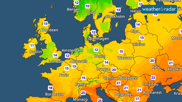
After the sweltering nights of recent days, many people across Europe can finally breathe a sigh of relief with temperatures are dropping noticeably at night.

Cooler nights are coming particularly in Western and Central Europe, and later on in Eastern Central Europe as well.

This makes it much easier to air the home in the mornings and evenings. In many places, temperatures will drop to a pleasant 18 to 12°C. From northern France through northern Germany to eastern Poland, temperatures will at times even drop to 10°C.

It will remain cooler in many places overnight into Saturday. Dropping to 10°C or below in parts.

But that doesn’t mean summer is quite over yet. During the day, it remains warm to hot in many regions. However, the cooler nights give our bodies a chance to catch their breath. Many of us also find it easier to sleep again.

Nights are cooler here tooread more
Weather & Radar editorial team
More on the topic
Rain and blustery winds spread. Frontal influence. . . Wednesday, 2 September 2026
Split weather graphic showing widespread rain across the UK and Ireland alongside winds of 25-35 mph, strongest around Cardiff and the south of the UK.
Wednesday, 2 September 2026

Frontal influence

Rain and blustery winds spread
Europe's storm situation still volatile. Supercell danger. . . Friday, 28 August 2026
Split screen. On the left, a weather map of Europe showing thunderstorms, lightning and a warning symbol. On the right, a photograph of a severe thunderstorm
Friday, 28 August 2026

Supercell danger

Europe's storm situation still volatile
A generally gusty Thursday. Moderate but notable wind. . . Wednesday, 2 September 2026
Wind forecast showing widespread 25-30 mph winds across the UK and Ireland, including Glasgow, Dublin, Cork, Cardiff, and London, with a windsock symbol.
Wednesday, 2 September 2026

Moderate but notable wind

A generally gusty Thursday
All weather news
This might also interest you
Historic Storm Éowyn arrives. On this day.... . . Saturday, 24 January 2026
Split image showing a person in a yellow jacket struggling against strong winds and heavy rain on a street at night on the left, and an Irish wind forecast map on the right with red and purple shading, gusts up to 75 mph, and a wind warning icon, divided by a curved white line.
Saturday, 24 January 2026

On this day...

Historic Storm Éowyn arrives
Flooding, gales, and heavy snow. Storm Chandra. . . Tuesday, 27 January 2026
Split image showing aerial flooding in a town with muddy water covering roads on the left, and a rural road on the right blocked by heavy snowfall with vans stopped and a person walking in snow.
Tuesday, 27 January 2026

Storm Chandra

Flooding, gales, and heavy snow
A stormy week in the skies above. Your weather - Your shots. . . Sunday, 30 August 2026
Split image showing lightning branching beneath dark storm clouds above rooftops on the left and an orange-pink sunset over a calm sea on the right.
Sunday, 30 August 2026

Your weather - Your shots

A stormy week in the skies above
All articles
Weather & Radar

Weather & Radar is also available on

Google Play StoreApp Store

Company

Contact us Privacy Policy Legal info Accessibility statement

Services

Uploader

Socials

facebooktwittertikToklinkList