Home
Weather London
WeatherRadar
RainfallRadar
TemperatureRadar
WindRadar
LightningRadar
Weather News
Editor's Pick
Discover the app
Weather widget
Contact us
Apps
Career
    Home /

    More disruption expected - Storm Boelo blows through the weekend

16:15
23 October 2026

More disruption expected
Storm Boelo blows through the weekend

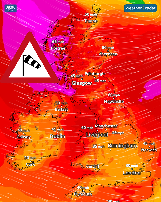
Gusts of up to 80 mph are expected in Scotland this weekend, with heavy rain across the UK and Ireland as Storm Boelo follows Austen, Weather & Radar meteorologist Lars has the latest.

The second storm in as many days will bring more widespread gusts of 60 to 70 mph across Scotland, with the more severe 80 mph gusts hitting exposted coasts to the west.

While Scotland will be the worst hit, gusts of 40 to 55 mph are expected across the UK and Ireland, again stronger in the west. Be sure to double-check garden furniture is secure and vehicles are parked away from potential debris.

Wind forecast at 08:00 on 25.10 showing widespread 45–65 mph winds across the UK and Ireland, with purple and red zones and a warning symbol.
Sunday morning brings a very active WindRadar.

The impact of Boelo grows stronger Saturday evening, with the most severe winds arriving early Sunday morning.

Through Saturday heavy rain will spread across both countries, first spreading eastwards across Ireland to start the day before moving into the UK as the day goes on.

By Saturday evening acculmulations of up to 90 mm are possible in Eyri (Snowdonia), up to 70 mm around Exmoor, and 60 mm in Connemara. Keep an eye on local flood alerts.

London

Fr
11
13
Sa
7
15
Su
10
14
Mo
9
17
Tu
16
17
We
9
15
Th
9
15
Fr
10
16
Sa
11
17
Su
11
15
Mo
9
15
Tu
9
15
We
10
15
Th
10
16
Max (°C)
Min (°C)
moreless

Manchester

Fr
7
12
Sa
6
12
Su
9
11
Mo
7
16
Tu
15
15
We
9
14
Th
9
14
Fr
10
15
Sa
8
13
Su
8
12
Mo
8
13
Tu
8
12
We
7
12
Th
8
13
Max (°C)
Min (°C)
moreless

Dublin

Fr
6
10
Sa
6
14
Su
8
11
Mo
7
18
Tu
11
11
We
8
15
Th
10
14
Fr
12
13
Sa
5
11
Su
6
12
Mo
8
14
Tu
7
13
We
7
13
Th
9
13
Max (°C)
Min (°C)
moreless

Edinburgh

Fr
1
7
Sa
3
10
Su
8
10
Mo
7
14
Tu
14
14
We
8
13
Th
10
15
Fr
10
14
Sa
7
11
Su
7
12
Mo
7
12
Tu
8
13
We
7
12
Th
8
12
Max (°C)
Min (°C)
moreless

Cardiff

Fr
10
11
Sa
7
15
Su
10
13
Mo
10
16
Tu
13
13
We
10
15
Th
11
15
Fr
11
16
Sa
10
14
Su
9
14
Mo
9
13
Tu
8
13
We
8
12
Th
9
14
Max (°C)
Min (°C)
moreless
Weather & Radar editorial team

More on the topic

Severe weather in the south of France. Holiday spots affected. . . Monday, 19 October 2026
A severe weather warning for heavy rain has been issued for the south of France.
Monday, 19 October 2026

Holiday spots affected

Severe weather in the south of France
First major storm of the season. Storm Austen named. . . Tuesday, 20 October 2026
On the left, WindRadar shows a storm system over the UK with strong winds. On the right, high waves are crashing against a sea wall. A warning symbol indicates a storm.
Tuesday, 20 October 2026

Storm Austen named

First major storm of the season
Winds grow and rain spreads Wednesday. Prelude to Austen. . . Wednesday, 21 October 2026
Split weather map showing strong winds up to 40 mph across southern Britain and blue rain bands over Scotland, Ireland and England, with warning symbols.
Wednesday, 21 October 2026

Prelude to Austen

Winds grow and rain spreads Wednesday
All weather news

This might also interest you

Severe weather brings disruption. Gales and rain. . . Wednesday, 14 October 2026
Split weather graphic showing winds up to 45 mph near Aberdeen and red, orange and yellow wind warning zones across Scotland and Ireland.
Wednesday, 14 October 2026

Gales and rain

Severe weather brings disruption
Former hurricane to record storm. Isaias affecting Europe. . . Wednesday, 14 October 2026
WindRadar shows a powerful storm system south-west of Iceland. Red and purple colours indicate extreme wind speeds. Arrows show the direction of rotation, whilst a windsock symbol warns of a storm.
Wednesday, 14 October 2026

Isaias affecting Europe

Former hurricane to record storm
Severe weather hits Turkey and Greece. Torrential rain and storms. . . Thursday, 15 October 2026
On the left, a yellow bus is submerged in deep floodwater. On the right, the weather radar shows numerous thunderstorms over Greece and Turkey. Warning symbols indicate flooding and thunderstorms.
Thursday, 15 October 2026

Torrential rain and storms

Severe weather hits Turkey and Greece
All articles
Weather & Radar

Weather & Radar is also available on

Google Play StoreApp Store

Company

Contact us Privacy Policy Legal info Accessibility statement

Services

Uploader

Socials

facebooktwittertikToklinkList