Home
Weather London
WeatherRadar
RainfallRadar
TemperatureRadar
WindRadar
LightningRadar
Weather News
Editor's Pick
Discover the app
Weather widget
Contact us
Apps
Career
    Home / Editor's Pick /

    Make a wish! Lyrid meteor shower reaches its peak

17:00
22 April 2026

Make a wish!
Lyrid meteor shower reaches its peak

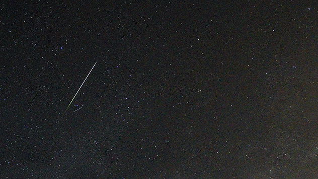
Bright meteor streak cutting diagonally across a star-filled night sky, leaving a glowing trail against a dark backdrop of scattered stars.
Shooting stars pictured over Germany during last year's shower. - © Torsten Brehme

The oldest meteor shower on record reaches its peak tonight, with good visibility for most but not in Scotland and north-east England.

With a high of around 18 meteors an hour, the Lyrids are at their most active Saturday evening into the early hours of Sunday.

As the display reaches its crescendo, clouds part over Ireland and Wales offering an uninterrupted view. Though stubborn cloud cover across much of Scotland and eastern England hinders the ability to wish upon a shooting star this time.

While the shower reaches its peak tonight, it remains active until April 25th. Meanwhile, the Eta Aquariids is also now active.

The Lyrid meteor shower is associated with the long-lived comet C/1861 G1 Thatcher. In fact, it is the oldest recorded meteor shower still visible today, first recorded in 687 BC.

Keep an eye on the WeatherRadar to find the best visibility, and if you happen to catch a shooting star use the uploader to show us!

Ryan Hathaway

More on the topic

Warnings live across the UK and Ireland. How do they work?. . . Tuesday, 20 October 2026
Weather warning map showing yellow and orange wind alerts across Ireland and England, with red level 3 areas in southwest England and a windsock symbol.
Tuesday, 20 October 2026

How do they work?

Warnings live across the UK and Ireland
High-pressure shifts the weather pattern. Change in Europe. . . Friday, 16 October 2026
Split European weather maps showing low pressure near Norway shifting to high pressure over Scandinavia, with arrows indicating changing airflow patterns.
Friday, 16 October 2026

Change in Europe

High-pressure shifts the weather pattern
First major storm of the season. Storm Austen named. . . Tuesday, 20 October 2026
On the left, WindRadar shows a storm system over the UK with strong winds. On the right, high waves are crashing against a sea wall. A warning symbol indicates a storm.
Tuesday, 20 October 2026

Storm Austen named

First major storm of the season
All weather news

This might also interest you

A stormy week in the skies above. Your weather - Your shots. . . Sunday, 30 August 2026
Split image showing lightning branching beneath dark storm clouds above rooftops on the left and an orange-pink sunset over a calm sea on the right.
Sunday, 30 August 2026

Your weather - Your shots

A stormy week in the skies above
Long-term trends need a pinch of salt. 40 °C in July?. . . Tuesday, 30 June 2026
Temperature radar of 2022 heatwave where the all-time temperature record in the UK was set. Warning symbol overlain.
Tuesday, 30 June 2026

40 °C in July?

Long-term trends need a pinch of salt
Super Typhoon Bavi threatens Taiwan. Up to 1,000 mm of rain. . . Wednesday, 8 July 2026
The image shows an intense tropical cyclone over the western Pacific, east of Taiwan and the Philippines. The centre of the system is depicted as a light purple and white vortex with a clearly visible eye, surrounded by a ring of red and orange areas indicating the strongest wind speeds. A white arrow marks the typhoon’s predicted track towards the north-west, in the direction of Taiwan. To the west of the storm lie the Philippines, with the cities of Manila and Cebu; to the north of these lies Taiwan, with Taipei. Further west, the Chinese coast, including Hong Kong, and parts of Vietnam can be seen. The coloured wind map shows predominantly green areas outside the storm’s core, indicating significantly weaker winds. White streamlines illustrate the typhoon’s anti-clockwise circulation in the Northern Hemisphere. The highest wind speeds are concentrated around the eye of the cyclone.
Wednesday, 8 July 2026

Up to 1,000 mm of rain

Super Typhoon Bavi threatens Taiwan
All articles
Weather & Radar

Weather & Radar is also available on

Google Play StoreApp Store

Company

Contact us Privacy Policy Legal info Accessibility statement

Services

Uploader

Socials

facebooktwittertikToklinkList