Home
Weather London
WeatherRadar
RainfallRadar
TemperatureRadar
WindRadar
LightningRadar
Weather News
Editor's Pick
Discover the app
Weather widget
Contact us
Apps
Career
    Home / Editor's Pick /

    Major incident declared: Flood warnings as heavy rain returns

15:00
4 January 2024

Major incident declared
Flood warnings as heavy rain returns

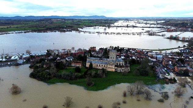
Abbey surrounded by flooded fields
Tewkesbury Abbey on Wednesday was surrounded by floodwater after days of heavy rainfall. - © picture alliance

Major flooding continues to break out across the United Kingdom, with weather and flood warnings in place as Nottinghamshire declares a major incident.

Heavy rain along the southern English coastline this afternoon and continued showers across much of the UK prompted around 500 flood warnings to be issued, primarily across England today.

Although not all areas see a return of torrential rainfall, which is largely confined to the south and south-east of England, many areas have seen soil saturated with rainfall from Storm Henk. Making repeated flooding from fresh rainfall more likely, even with lesser amounts.

A major incident has been declared by Nottinghamshire County Council as the River Trent approaches record high levels. Key tributaries, such as the River Derwent and River Dove, are already receding. However, the Trent itself is swelling, with high water levels running down the river increasingly making flooding likely.

The current record high for the Trent 5.5 m recorded in November 2000. In Worcester, flood barriers are being installed along the River Severn which is likely to peak on Friday morning with the potential to also set a record-high.

Elsewhere, Great Western Railway says that any commuters heading to Cornwall, Devon, Somerset, or Wiltshire today should travel as soon as possible with disruption to lines expected later today.

Privacy Policy

With weather warnings in place until the early hours of Friday, there may be more disruption ahead. Strong gusting winds begin to build again into the evening, strongest on the south coast. On the Channel Islands, gusts reaching up to 74 mph are likely.

Torrential rainfall is already falling across the southern coast, and will push north-east into East Anglia, brushing parts of the East Midlands, into the evening.

There is some potential for thunderstorms to develop, however it currently appears that these will be restricted offshore in the English Channel.

Follow events as they develop with the WeatherRadar and WindRadar.

Tips: Preparing for a floodread more
Weather & Radar editorial team
More on the topic
Rain returns to end dry spell in places. Jet stream delivery. . . Thursday, 23 July 2026
Split weather graphic showing widespread showers across the UK and Ireland on the left, and a wind forecast map on the right with a windsock icon and gusts of 25 to 35 mph, highlighting breezy conditions across the two countries.
Thursday, 23 July 2026

Jet stream delivery

Rain returns to end dry spell in places
Heat becoming a bigger factor in drought. New study. . . Thursday, 23 July 2026
A hand holds dry, dusty earth above a parched field. The ground is cracked and covered with plant debris – a sign of prolonged drought.
Thursday, 23 July 2026

New study

Heat becoming a bigger factor in drought
Drought for North Wales and Upper Severn. 2% of average rainfall. . . Thursday, 23 July 2026
Split image showing a July rainfall anomaly map of Europe on the left with below-average rainfall across the UK, Ireland, and much of western and central Europe, and an active moorland wildfire on the right producing flames and thick smoke near homes.
Thursday, 23 July 2026

2% of average rainfall

Drought for North Wales and Upper Severn
All weather news
This might also interest you
Seasonal warmth between spring thunder. Your weather - Your shots. . . Sunday, 19 April 2026
Split image showing coastal sunset with layered lenticular clouds over rooftops and palm trees on the left, and a green valley with river and hills under soft daylight on the right.
Sunday, 19 April 2026

Your weather - Your shots

Seasonal warmth between spring thunder
Long-term trends need a pinch of salt. 40 °C in July?. . . Tuesday, 30 June 2026
Temperature radar of 2022 heatwave where the all-time temperature record in the UK was set. Warning symbol overlain.
Tuesday, 30 June 2026

40 °C in July?

Long-term trends need a pinch of salt
Historic Storm Éowyn arrives. On this day.... . . Saturday, 24 January 2026
Split image showing a person in a yellow jacket struggling against strong winds and heavy rain on a street at night on the left, and an Irish wind forecast map on the right with red and purple shading, gusts up to 75 mph, and a wind warning icon, divided by a curved white line.
Saturday, 24 January 2026

On this day...

Historic Storm Éowyn arrives
All articles
Weather & Radar

Weather & Radar is also available on

Google Play StoreApp Store

Company

Contact us Privacy Policy Legal info Accessibility statement

Services

Uploader

Socials

facebooktwittertikToklinkList