Home
Weather London
WeatherRadar
RainfallRadar
TemperatureRadar
WindRadar
LightningRadar
Weather News
Editor's Pick
Discover the app
Weather widget
Contact us
Apps
Career
    Home / Editor's Pick /

    Lightning strikes in dry conditions - positive earth flashes

13:50
17 August 2026

Positive earth flashes
Lightning strikes in dry conditions

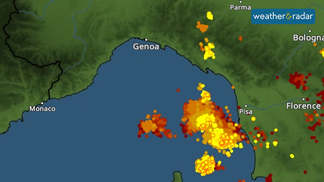
Severe thunderstorms developed around Genoa, Italy in recent days, with lightning strikes reaching the ground even away from the thunderclouds, an event known as positive ground flashes.

Positive ground flashes are relatively rare: only around 5 to 10% of all ground flashes are of this type. They usually originate high up in the thundercloud and can travel an astonishingly long distance from there.

For example, a bolt of lightning can strike many kilometres away from the actual thunderstorm – even in dry conditions. The images from the Gulf of Liguria near Genoa illustrate this impressively.

LightningRadar showing lightning strikes in the Gulf of Liguria.

This means that there may still be a risk of lightning, even if the storm clouds seem a distance away and there's no rain falling in the area. The LightningRadar shows at a glance recent strikes so you can stay alert to lighting around you.

Positive ground flashes are also dangerous because they can reach particularly high current levels. As a result, they are often significantly more powerful than ordinary negative ground flashes. They occur mainly during severe thunderstorms.

Weather & Radar editorial team
More on the topic
The solar eclipse arrives tonight. Great visibility for most. . . Wednesday, 12 August 2026
Split image showing an annular solar eclipse on the left and a UK and Ireland weather map on the right with mostly sunny skies, temperatures of 30–31°C in England and 27°C in Dublin.
Wednesday, 12 August 2026

Great visibility for most

The solar eclipse arrives tonight
Europe's summer set to to break records. Extreme heat and drought. . . Tuesday, 11 August 2026
Split image showing a European heat map with temperatures reaching 39°C in France and Spain on the left, and a severely depleted river with exposed sandy banks beneath a bridge on the right.
Tuesday, 11 August 2026

Extreme heat and drought

Europe's summer set to to break records
Late season views as summer rolls on. Your weather - Your shots. . . Sunday, 9 August 2026
Split image showing a horseback ride along a green hillside trail beneath blue skies on the left and a small sailboat on a calm coastal bay under broken clouds on the right.
Sunday, 9 August 2026

Your weather - Your shots

Late season views as summer rolls on
All weather news
This might also interest you
Super Typhoon Bavi threatens Taiwan. Up to 1,000 mm of rain. . . Wednesday, 8 July 2026
The image shows an intense tropical cyclone over the western Pacific, east of Taiwan and the Philippines. The centre of the system is depicted as a light purple and white vortex with a clearly visible eye, surrounded by a ring of red and orange areas indicating the strongest wind speeds. A white arrow marks the typhoon’s predicted track towards the north-west, in the direction of Taiwan. To the west of the storm lie the Philippines, with the cities of Manila and Cebu; to the north of these lies Taiwan, with Taipei. Further west, the Chinese coast, including Hong Kong, and parts of Vietnam can be seen. The coloured wind map shows predominantly green areas outside the storm’s core, indicating significantly weaker winds. White streamlines illustrate the typhoon’s anti-clockwise circulation in the Northern Hemisphere. The highest wind speeds are concentrated around the eye of the cyclone.
Wednesday, 8 July 2026

Up to 1,000 mm of rain

Super Typhoon Bavi threatens Taiwan
Bright and warm conditions take hold. Spring-like outlook. . . Thursday, 23 April 2026
Split UK map showing warm temperatures up to 21 degrees in orange on the left and clear sunny conditions with temperatures from 12 to 18 degrees on the right, with sun icons across the country.
Thursday, 23 April 2026

Spring-like outlook

Bright and warm conditions take hold
Flooding, gales, and heavy snow. Storm Chandra. . . Tuesday, 27 January 2026
Split image showing aerial flooding in a town with muddy water covering roads on the left, and a rural road on the right blocked by heavy snowfall with vans stopped and a person walking in snow.
Tuesday, 27 January 2026

Storm Chandra

Flooding, gales, and heavy snow
All articles
Weather & Radar

Weather & Radar is also available on

Google Play StoreApp Store

Company

Contact us Privacy Policy Legal info Accessibility statement

Services

Uploader

Socials

facebooktwittertikToklinkList