Home
Weather London
WeatherRadar
RainfallRadar
TemperatureRadar
WindRadar
LightningRadar
Weather News
Editor's Pick
Discover the app
Weather widget
Contact us
Apps
Career
    Home / Editor's Pick /

    Light display for Europe: Northern lights reach southern England

12:17
6 November 2023

Light display for Europe
Northern lights reach southern England

Privacy Policy

The northern lights danced across the skies of the UK and Ireland, even reaching as far south as Cornwall.

Typically confined to more northern latitudes, the Aurora Borealis graced our skies in recent days.

Across the UK and Ireland during the early hours of Sunday November 5th, the aurora borealis graced our skies, much further south than is usual, reaching parts of southern England such as Cornwall and Wiltshire.

While cloud, mist and fog skewed the view for some, skies cleared to even allow the sight to be seen by the naked eye. More often that not, especially at our latitudes, the aurora is only visible through camera equipment attuned to capture the colours.

The Northern Lights can descend over England, Wales, and Ireland during times of increased solar activity, for example during geomagnetic storms.

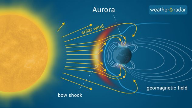
During these storms, the sun hires tremendous amounts of solar materials from coronal mass ejections or sunspots, which react with the magnetosphere. In this instance, a moderate G2 storm due to a coronal mass ejection was the cause.

As the solar wind approaches Earth, it encounters a shock wave known as a bow shock, where the wind interacts with our Earth's magnetic field.

Other parts of Northern, Central and Eastern Europe witnessed the spectacle too, including Germany, Romania, Slovakia, Hungary, Ukraine and even Bulgaria for the first time in history.

Ladakh, in the northern Indian subcontinent, also witnessed the aurora for the first time ever earlier this year. Scientists predict that sunspot observations will grow in the next 18 months to its highest in 20 years, with more areas perhaps able to witness the magic of the aurora.

Despite the strength of the geomagnetic storm, living in large cities can hamper your chance of spotting the spectacle due to light pollution masking the night sky. The weather can also make for difficult viewing conditions.

Auroras are also tricky to forecast, harder than our weather. The best way is to monitor the KP Index. This is a scale which tracks geomagnetic activity and runs from level zero to nine.

What causes the aurora?read more

For the lights to appear over England, a KP Index of five is generally required. Even then, we need clear, dark skies and a pinch of luck for one of nature's most awe-inspiring sights to appear.

Did you catch a glimpse? If you did, be sure to send in your shots for us to share via our uploader.

More on the topic
Severe damage along the Adriatic coast. Huge hail and storms. . . Wednesday, 22 July 2026
Two hands are holding huge hailstones; next to them is a weather map showing thunderstorms and frequent lightning over the Adriatic coast and the western Balkans.
Wednesday, 22 July 2026

Huge hail and storms

Severe damage along the Adriatic coast
Rain returns to end dry spell in places. Jet stream delivery. . . Thursday, 23 July 2026
Split weather graphic showing widespread showers across the UK and Ireland on the left, and a wind forecast map on the right with a windsock icon and gusts of 25 to 35 mph, highlighting breezy conditions across the two countries.
Thursday, 23 July 2026

Jet stream delivery

Rain returns to end dry spell in places
Heat becoming a bigger factor in drought. New study. . . Thursday, 23 July 2026
A hand holds dry, dusty earth above a parched field. The ground is cracked and covered with plant debris – a sign of prolonged drought.
Thursday, 23 July 2026

New study

Heat becoming a bigger factor in drought
All weather news
This might also interest you
Super Typhoon Bavi threatens Taiwan. Up to 1,000 mm of rain. . . Wednesday, 8 July 2026
The image shows an intense tropical cyclone over the western Pacific, east of Taiwan and the Philippines. The centre of the system is depicted as a light purple and white vortex with a clearly visible eye, surrounded by a ring of red and orange areas indicating the strongest wind speeds. A white arrow marks the typhoon’s predicted track towards the north-west, in the direction of Taiwan. To the west of the storm lie the Philippines, with the cities of Manila and Cebu; to the north of these lies Taiwan, with Taipei. Further west, the Chinese coast, including Hong Kong, and parts of Vietnam can be seen. The coloured wind map shows predominantly green areas outside the storm’s core, indicating significantly weaker winds. White streamlines illustrate the typhoon’s anti-clockwise circulation in the Northern Hemisphere. The highest wind speeds are concentrated around the eye of the cyclone.
Wednesday, 8 July 2026

Up to 1,000 mm of rain

Super Typhoon Bavi threatens Taiwan
Bright and warm conditions take hold. Spring-like outlook. . . Thursday, 23 April 2026
Split UK map showing warm temperatures up to 21 degrees in orange on the left and clear sunny conditions with temperatures from 12 to 18 degrees on the right, with sun icons across the country.
Thursday, 23 April 2026

Spring-like outlook

Bright and warm conditions take hold
New records for England and Wales. Broken again tomorrow?. . . Thursday, 25 June 2026
Temperature map of southwest Britain on 25.06 showing extreme heat across southern Wales and southwest England, with Bute Park in Cardiff highlighted at 34.2°C and Yeovilton at 36.4°C amid widespread deep red heat zones.
Thursday, 25 June 2026

Broken again tomorrow?

New records for England and Wales
All articles
Weather & Radar

Weather & Radar is also available on

Google Play StoreApp Store

Company

Contact us Privacy Policy Legal info Accessibility statement

Services

Uploader

Socials

facebooktwittertikToklinkList