Home
Weather London
WeatherRadar
RainfallRadar
TemperatureRadar
WindRadar
LightningRadar
Weather News
Editor's Pick
Discover the app
Weather widget
Contact us
Apps
Career
    Home / Editor's Pick /

    Jet stream delivery - Rain returns to end dry spell in places

09:00
23 July 2026

Jet stream delivery
Rain returns to end dry spell in places

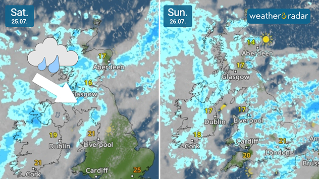
Split weather radars comparing Saturday 25.07 and Sunday 26.07 across the UK and Ireland. Saturday shows rain moving southeast across Scotland with an arrow indicating its direction, while Sunday brings widespread showers across the UK and Ireland.
A welcome sight for many on the WeatherRadar.

While parts of England are perilously close to drought, there is some relief on the way with a return of more widespread rain for the first time in a month for some.

High pressure has been dominating summer, keeping Atlantic systems at bay. This weekend, a weak frontal system will pass through, bringing a change to the dry, calm weather of recent weeks.

From Saturday, a band of rain moves south-east from Scotland and north-west Ireland through Wales into central England, a region which has seen its driest spell in 30 years.

By Sunday, it is expected that the rain will cover much of the UK and Ireland amid generally gloomy conditions, though the strongest of the winds will be felt at the onset of the system Saturday.

This rainfall may be good news for parched gardens and dusty cars, but it won't be heavy or sustained enough to truly help with the drought situation, around 5 to 10 mm of rain is expected over higher ground in northern England, Wales, and Northern Ireland, with up to 20 mm for western Scotland.

Amounts are lower further south and with ground soil having spent over a month baking in the sun it is likely too dry to really absorb much of the moisture.

Ryan Hathaway
More on the topic
Drought across large parts of Europe. High fire risk. . . Monday, 20 July 2026
Split image showing a Europe rainfall anomaly map on the left with widespread dry conditions across much of the continent, and a cracked, parched field on the right alongside a wildfire warning symbol highlighting elevated fire risk.
Monday, 20 July 2026

High fire risk

Drought across large parts of Europe
Sweltering heat in Sardinia. Up to 47°C. . . Saturday, 18 July 2026
A temperature map of Sardinia shows temperatures ranging from 38 to 46 degrees.
Saturday, 18 July 2026

Up to 47°C

Sweltering heat in Sardinia
Fiery summer snaps and video moments. Your weather - Your shots. . . Sunday, 19 July 2026
Split image showing vivid orange clouds glowing at sunset on the left and bright sunbeams streaming through scattered clouds above a rocky coastline and calm sea on the right.
Sunday, 19 July 2026

Your weather - Your shots

Fiery summer snaps and video moments
All weather news
This might also interest you
Long-term trends need a pinch of salt. 40 °C in July?. . . Tuesday, 30 June 2026
Temperature radar of 2022 heatwave where the all-time temperature record in the UK was set. Warning symbol overlain.
Tuesday, 30 June 2026

40 °C in July?

Long-term trends need a pinch of salt
New records for England and Wales. Broken again tomorrow?. . . Thursday, 25 June 2026
Temperature map of southwest Britain on 25.06 showing extreme heat across southern Wales and southwest England, with Bute Park in Cardiff highlighted at 34.2°C and Yeovilton at 36.4°C amid widespread deep red heat zones.
Thursday, 25 June 2026

Broken again tomorrow?

New records for England and Wales
Super Typhoon Bavi threatens Taiwan. Up to 1,000 mm of rain. . . Wednesday, 8 July 2026
The image shows an intense tropical cyclone over the western Pacific, east of Taiwan and the Philippines. The centre of the system is depicted as a light purple and white vortex with a clearly visible eye, surrounded by a ring of red and orange areas indicating the strongest wind speeds. A white arrow marks the typhoon’s predicted track towards the north-west, in the direction of Taiwan. To the west of the storm lie the Philippines, with the cities of Manila and Cebu; to the north of these lies Taiwan, with Taipei. Further west, the Chinese coast, including Hong Kong, and parts of Vietnam can be seen. The coloured wind map shows predominantly green areas outside the storm’s core, indicating significantly weaker winds. White streamlines illustrate the typhoon’s anti-clockwise circulation in the Northern Hemisphere. The highest wind speeds are concentrated around the eye of the cyclone.
Wednesday, 8 July 2026

Up to 1,000 mm of rain

Super Typhoon Bavi threatens Taiwan
All articles
Weather & Radar

Weather & Radar is also available on

Google Play StoreApp Store

Company

Contact us Privacy Policy Legal info Accessibility statement

Services

Uploader

Socials

facebooktwittertikToklinkList