Home
Weather London
WeatherRadar
RainfallRadar
TemperatureRadar
WindRadar
LightningRadar
Weather News
Editor's Pick
Discover the app
Weather widget
Contact us
Apps
Career
    Home / Editor's Pick /

    Hurricane-force gusts and flash floods – Hurricane Lowell threatens Hawaii

09:48
8 September 2026

Gales and flash floods
Hurricane Lowell threatens Hawaii

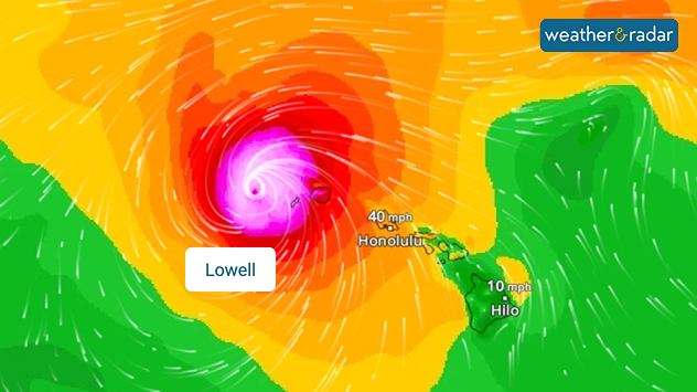
Hurricane Lowell is set to hit Hawaii. The western parts of the Pacific archipelago is bracing for hurricane-force winds of up to 124 mph.

The tropical storm is bringing with it heavy rainfall of up to 300 mm and dangerous waves.

WindRadar showing Hurricane Lowell north-west of Hawaii and its well-defined storm centre.
Hurricane Lowell on the WindRadar, just off the coast of the Hawaiian Islands

As a result, flash floods, landslides and power cuts are possible. As a precautionary measure, the authorities on Kauai have closed schools, government offices, parks, and campsites. Along the coast, residents in at-risk areas have been urged to prepare for evacuation.

It was only in August that Tropical Storm Lala struck the Hawaiian Islands and caused damage.

Keep an eye on developmentsLowell on WindRadar
Weather & Radar editorial team

More on the topic

Severe weather in the south of France. Holiday spots affected. . . Monday, 19 October 2026
A severe weather warning for heavy rain has been issued for the south of France.
Monday, 19 October 2026

Holiday spots affected

Severe weather in the south of France
Warnings live across the UK and Ireland. How do they work?. . . Tuesday, 20 October 2026
Weather warning map showing yellow and orange wind alerts across Ireland and England, with red level 3 areas in southwest England and a windsock symbol.
Tuesday, 20 October 2026

How do they work?

Warnings live across the UK and Ireland
Preparing for the storms. What to do now. . . Thursday, 22 October 2026
Split image showing Storm Austen winds up to 65 mph near Brest and 55 mph near Plymouth, alongside fallen tree branches on a cordoned-off park path.
Thursday, 22 October 2026

What to do now

Preparing for the storms
All weather news

This might also interest you

A frozen start to the weekend. Icy conditions. . . Friday, 13 February 2026
UK temperature map dated 14.02 showing widespread subzero values in blue shading, with readings such as −4 in Glasgow, −3 in Dublin, and −2 in London, alongside a blue thermometer icon.
Friday, 13 February 2026

Icy conditions

A frozen start to the weekend
Historic Storm Éowyn arrives. On this day.... . . Saturday, 24 January 2026
Split image showing a person in a yellow jacket struggling against strong winds and heavy rain on a street at night on the left, and an Irish wind forecast map on the right with red and purple shading, gusts up to 75 mph, and a wind warning icon, divided by a curved white line.
Saturday, 24 January 2026

On this day...

Historic Storm Éowyn arrives
New records for England and Wales. Broken again tomorrow?. . . Thursday, 25 June 2026
Temperature map of southwest Britain on 25.06 showing extreme heat across southern Wales and southwest England, with Bute Park in Cardiff highlighted at 34.2°C and Yeovilton at 36.4°C amid widespread deep red heat zones.
Thursday, 25 June 2026

Broken again tomorrow?

New records for England and Wales
All articles
Weather & Radar

Weather & Radar is also available on

Google Play StoreApp Store

Company

Contact us Privacy Policy Legal info Accessibility statement

Services

Uploader

Socials

facebooktwittertikToklinkList