Home
Weather London
WeatherRadar
RainfallRadar
TemperatureRadar
WindRadar
LightningRadar
Weather News
Editor's Pick
Discover the app
Weather widget
Contact us
Apps
Career
    Home / Editor's Pick /

    Hurricane Erin moves towards Europe: Impact on our weather

07:00
22 August 2025

Conversion to low
Hurricane Erin moves towards Europe

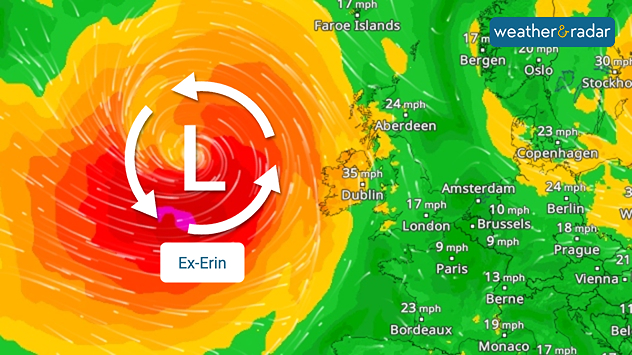
WindRadar forecast for Monday: Former Hurricane Erin reaches Europe as an extratropical storm.

Hurricane Erin is currently wreaking havoc over the Atlantic. It is now moving towards Europe as it transforms into a large, powerful extratropical storm.

Did you know?

Former tropical cyclones that reach Central Europe as low-pressure or storm systems are abbreviated with "Ex-” and the name of the former tropical cyclone – in this case, "Ex-Erin”.

At the beginning of next week, Erin will be located west of Ireland. The wind field of the low-pressure system, i.e. the area where strong gusts occur, will then be considerable, covering more than 1,500 kilometres. However, as things stand today, the strongest gusts will remain over the Atlantic.

Impact in Europe

Due to its considerable size, Ex-Erin also influences the weather in Europe:

The exact path of the low pressure system is still uncertain. However, as things stand today, it is expected to remain in Northern Europe for a longer period of time and possibly influence the weather for several days at a time.

Sebastian Keßler
Ryan Hathaway
More on the topic
Parts of England inching towards drought. Low rivers & reservoirs. . . Wednesday, 22 July 2026
People relaxing in a park during hot weather ,with one person sunbathing on dry yellow grass beneath large leafy trees under a blue sky with scattered fair-weather clouds.
Wednesday, 22 July 2026

Low rivers & reservoirs

Parts of England inching towards drought
A wet start before conditions settle. Commonwealth Games 2026. . . Wednesday, 22 July 2026
Split image showing a weather map for western Scotland with widespread rain around Glasgow on the left, and runners poised at a starting line on an athletics track on the right.
Wednesday, 22 July 2026

Commonwealth Games 2026

A wet start before conditions settle
Drought across large parts of Europe. High fire risk. . . Monday, 20 July 2026
Split image showing a Europe rainfall anomaly map on the left with widespread dry conditions across much of the continent, and a cracked, parched field on the right alongside a wildfire warning symbol highlighting elevated fire risk.
Monday, 20 July 2026

High fire risk

Drought across large parts of Europe
All weather news
This might also interest you
Seasonal warmth between spring thunder. Your weather - Your shots. . . Sunday, 19 April 2026
Split image showing coastal sunset with layered lenticular clouds over rooftops and palm trees on the left, and a green valley with river and hills under soft daylight on the right.
Sunday, 19 April 2026

Your weather - Your shots

Seasonal warmth between spring thunder
A frozen start to the weekend. Icy conditions. . . Friday, 13 February 2026
UK temperature map dated 14.02 showing widespread subzero values in blue shading, with readings such as −4 in Glasgow, −3 in Dublin, and −2 in London, alongside a blue thermometer icon.
Friday, 13 February 2026

Icy conditions

A frozen start to the weekend
Storm Chandra makes impact. Severe gales & heavy rain. . . Tuesday, 27 January 2026
Split image showing strong winds over the UK on a forecast map and widespread rain and snow on a weather radar map.
Tuesday, 27 January 2026

Severe gales & heavy rain

Storm Chandra makes impact
All articles
Weather & Radar

Weather & Radar is also available on

Google Play StoreApp Store

Company

Contact us Privacy Policy Legal info Accessibility statement

Services

Uploader

Socials

facebooktwittertikToklinkList