Home
Weather London
WeatherRadar
RainfallRadar
TemperatureRadar
WindRadar
LightningRadar
Weather News
Editor's Pick
Discover the app
Weather widget
Contact us
Apps
Career
    Home / Editor's Pick /

    How do they work? Warnings live across the UK and Ireland

09:44
20 October 2026

How do they work?
Warnings live across the UK and Ireland

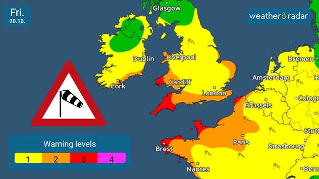
Weather warning map for Friday 20.10 showing yellow, orange and red wind alerts across southern Britain and northwest France, with a windsock symbol.
Current wind warnings stretch into Europe on Friday.

Multiple severe weather warnings are live in the app, with level three wind warnings in parts of the UK for Friday's gales.

Storm Austen is possible in the coming days, bringing heavy rain and gale-force winds. At the current time, the exact path of the system is still uncertain but warnings stretch across the UK, ending south of Scotland, and in large parts of Ireland.

These are warnings unique to Weather & Radar with our bespoke thresholds designed to help you understand the threat level faced by: wind, rain, thunderstorms, and snow/ice.

When a weather warning is live you can find the warning map by scrolling down on the home page to find the card. In the immediate build-up you will also see a message beneath the hourly forecast.

Our warnings update through the days, be sure to keep an eye on them and for Friday specifically on the WindRadar.

Stormy week with potential for Austenread more
Ryan Hathaway

More on the topic

Shooting stars from the Orionids peak. Mixed visibility overnight. . . Wednesday, 21 October 2026
Split image showing a bright green meteor streaking across a starry night sky beside a UK weather map with rain over Scotland and southern England.
Wednesday, 21 October 2026

Mixed visibility overnight

Shooting stars from the Orionids peak
Where do our storm names come from?. Austen possible this week. . . Monday, 19 October 2026
Lightning strikes beneath dark storm clouds over fields, with warning signs for thunderstorms and strong winds shown in foreground.
Monday, 19 October 2026

Austen possible this week

Where do our storm names come from?
Storm Boelo named. Weekend impacts. . . Thursday, 22 October 2026
Split weather maps showing Storm Boelo northwest of Scotland, winds reaching 50 mph near Glasgow and Liverpool, and spiralling Atlantic rain bands.
Thursday, 22 October 2026

Weekend impacts

Storm Boelo named
All weather news

This might also interest you

Bright and warm conditions take hold. Spring-like outlook. . . Thursday, 23 April 2026
Split UK map showing warm temperatures up to 21 degrees in orange on the left and clear sunny conditions with temperatures from 12 to 18 degrees on the right, with sun icons across the country.
Thursday, 23 April 2026

Spring-like outlook

Bright and warm conditions take hold
Historic Storm Éowyn arrives. On this day.... . . Saturday, 24 January 2026
Split image showing a person in a yellow jacket struggling against strong winds and heavy rain on a street at night on the left, and an Irish wind forecast map on the right with red and purple shading, gusts up to 75 mph, and a wind warning icon, divided by a curved white line.
Saturday, 24 January 2026

On this day...

Historic Storm Éowyn arrives
Storm Chandra makes impact. Severe gales & heavy rain. . . Tuesday, 27 January 2026
Split image showing strong winds over the UK on a forecast map and widespread rain and snow on a weather radar map.
Tuesday, 27 January 2026

Severe gales & heavy rain

Storm Chandra makes impact
All articles
Weather & Radar

Weather & Radar is also available on

Google Play StoreApp Store

Company

Contact us Privacy Policy Legal info Accessibility statement

Services

Uploader

Socials

facebooktwittertikToklinkList