Home
Weather London
WeatherRadar
RainfallRadar
TemperatureRadar
WindRadar
LightningRadar
Weather News
Editor's Pick
Discover the app
Weather widget
Contact us
Apps
Career
    Home / Editor's Pick /

    Heat dome - Trapped beneath a blanket of hot air

12:12
22 June 2026

Heat dome
Trapped beneath a blanket of hot air

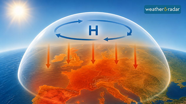
A strong area of high pressure has been hovering over south-western Europe for days. In many places, temperatures are reaching or even exceeding 40 °C due to what is known as a "heat dome".

However, the situation is particularly extreme not only because of the high temperatures, but because of their duration. Together with a persistent high-pressure system, the heat dome sits over the affected regions like a huge atmospheric bell.

Within what is known as a ‘heat dome’, hot air is trapped as if by an invisible dome.

It acts like an invisible lid over the atmosphere. The air, heated by the strong June sunshine, can barely escape and is further compressed and warmed by the high air pressure. Behind it lies a stable omega block, which keeps other weather systems at bay.

As a result, the heat can linger for days, sometimes even weeks. The current heatwave stretches from Spain through France to the UK and Germany. On the TemperatureRadar, the red and purple colours clearly show that the hot air mass is barely moving.

UK: Extreme heat takes holdread more
Jürgen Vollmer
More on the topic
Severe weather spreads across Europe. Lightning, hail, gales. . . Wednesday, 15 July 2026
Split image showing a dramatic supercell thunderstorm with dark rotating clouds over open countryside on the left, and a severe thunderstorm warning map on the right highlightning elevated storm risk across parts of central Europe, including northern Italy, Switzerland, eastern France, and southern Germany.
Wednesday, 15 July 2026

Lightning, hail, gales

Severe weather spreads across Europe
Wildfires break out amid ongoing drought. Water restrictions active. . . Tuesday, 14 July 2026
Smoke rising from a scorched moorland hillside after a wildfire, with blackened vegetation, smouldering ground, and drifting gray smoke covering the burned landscape.
Tuesday, 14 July 2026

Water restrictions active

Wildfires break out amid ongoing drought
Sea fog rolls into Pembrokeshire. Unique summer scene. . . Tuesday, 14 July 2026
Thick sea fog rolling inland over a sunlit bay, with sparkling water, trees and garden in the foreground, and a hill rising above the fog under a clear blue sky.
Tuesday, 14 July 2026

Unique summer scene

Sea fog rolls into Pembrokeshire
All weather news
This might also interest you
A frozen start to the weekend. Icy conditions. . . Friday, 13 February 2026
UK temperature map dated 14.02 showing widespread subzero values in blue shading, with readings such as −4 in Glasgow, −3 in Dublin, and −2 in London, alongside a blue thermometer icon.
Friday, 13 February 2026

Icy conditions

A frozen start to the weekend
Storm Chandra makes impact. Severe gales & heavy rain. . . Tuesday, 27 January 2026
Split image showing strong winds over the UK on a forecast map and widespread rain and snow on a weather radar map.
Tuesday, 27 January 2026

Severe gales & heavy rain

Storm Chandra makes impact
Flooding, gales, and heavy snow. Storm Chandra. . . Tuesday, 27 January 2026
Split image showing aerial flooding in a town with muddy water covering roads on the left, and a rural road on the right blocked by heavy snowfall with vans stopped and a person walking in snow.
Tuesday, 27 January 2026

Storm Chandra

Flooding, gales, and heavy snow
All articles
Weather & Radar

Weather & Radar is also available on

Google Play StoreApp Store

Company

Contact us Privacy Policy Legal info Accessibility statement

Services

Uploader

Socials

facebooktwittertikToklinkList