Home
Weather London
WeatherRadar
RainfallRadar
TemperatureRadar
WindRadar
LightningRadar
Weather News
Editor's Pick
Discover the app
Weather widget
Contact us
Apps
Career
    Home / Editor's Pick /

    Hail and storm damage - Violent storms impacting northern Italy

12:00
16 July 2026

Hail and storm damage
Violent storms impacting northern Italy

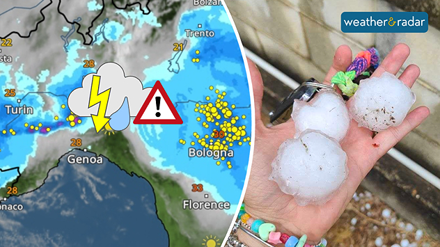
Severe thunderstorms swept through northern Italy on Wednesday afternoon. So-called supercells moved from Piedmont through Emilia-Romagna to Friuli-Venezia Giulia.

Did you know?

Supercells are among the most dangerous thunderstorms. They often bring large hailstones, torrential rain, and severe gusts of wind. The risk of tornadoes is also higher than with other types of thunderstorm.

In Piedmont, hailstones the size of golf balls fell in some places; near Turin, hail measuring up to 9 centimetres were reported. Around Bologna, gale-force winds of around 75 mph uprooted trees and damaged roofs, causing widespread disruption on the roads.

The WeatherRadar shows yesterday’s storms, which brought large to very large hailstones in some areas.

There is a risk of further severe localised thunderstorms in Italy today and tomorrow, particularly near the borders with France, Switzerland, and Austria. Keep an eye on the situation with the WeatherRadar.

Track thunderstorms liveGlobal WeatherRadar

Weather & Radar editorial team
More on the topic
Widespread thunderstorm risk in the UK. Heavy rain and hail too. . . Tuesday, 25 August 2026
Split weather graphic showing a yellow thunderstorm warning across much of England alongside radar with heavy showers and frequent lightning around London and southeast England.
Tuesday, 25 August 2026

Heavy rain and hail too

Widespread thunderstorm risk in the UK
Extreme heat in Italy. Up to 45 degrees. . . Wednesday, 26 August 2026
Split screen. On the left, a temperature map of Italy. On the right, a view of Taormina and Mount Etna
Wednesday, 26 August 2026

Up to 45 degrees

Extreme heat in Italy
Severe weather damage in France. Tornado impacts. . . Tuesday, 25 August 2026
On the left, the weather radar shows numerous flashes of lightning over the south of France. On the right, severe tornado damage can be seen in Pomas, with damaged roofs, trees and vehicles.
Tuesday, 25 August 2026

Tornado impacts

Severe weather damage in France
All weather news
This might also interest you
Long-term trends need a pinch of salt. 40 °C in July?. . . Tuesday, 30 June 2026
Temperature radar of 2022 heatwave where the all-time temperature record in the UK was set. Warning symbol overlain.
Tuesday, 30 June 2026

40 °C in July?

Long-term trends need a pinch of salt
A stormy week in the skies above. Your weather - Your shots. . . Sunday, 30 August 2026
Split image showing lightning branching beneath dark storm clouds above rooftops on the left and an orange-pink sunset over a calm sea on the right.
Sunday, 30 August 2026

Your weather - Your shots

A stormy week in the skies above
Flooding, gales, and heavy snow. Storm Chandra. . . Tuesday, 27 January 2026
Split image showing aerial flooding in a town with muddy water covering roads on the left, and a rural road on the right blocked by heavy snowfall with vans stopped and a person walking in snow.
Tuesday, 27 January 2026

Storm Chandra

Flooding, gales, and heavy snow
All articles
Weather & Radar

Weather & Radar is also available on

Google Play StoreApp Store

Company

Contact us Privacy Policy Legal info Accessibility statement

Services

Uploader

Socials

facebooktwittertikToklinkList