Home
Weather London
WeatherRadar
RainfallRadar
TemperatureRadar
WindRadar
LightningRadar
Weather News
Editor's Pick
Discover the app
Weather widget
Contact us
Apps
Career
    Home /

    Gusty start with fresh rain to end

10:20
9 October 2026

Weekend outlook
Gusty start with fresh rain to end

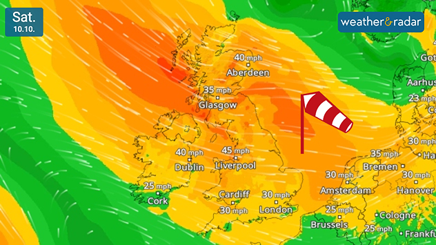
Wind forecast for Saturday 10/10 showing 45 mph near Liverpool, 40 mph near Dublin and Aberdeen, and a red windsock warning symbol over the North Sea.
The WindRadar stays active throughout Saturday for the UK and Ireland.

For many it will be a windswept start to the weekend with strong gusts persisting into Saturday evening, with an eye on fresh rainfall sweeping in on Sunday.

While Friday's winds ease across parts of England into Saturday morning, they quickly regather energy bringing gusts across the UK and Ireland. The strongest of these are expected across southern Scotland and northern England with around 40 mph expected in Edinburgh and Newcastle.

Similar gusts will be felt in parts of Northern Ireland though it is Ireland that sees the first easing of the conditions by Saturday night before things switch. Sunday itself is mostly calm for the UK but winds grow again from the west in Ireland.

Otherwise, there are showers to keep an eye on for Saturday across Scotland, and northern regions of England and Wales. These could turn snowy over the Cairngorms where the first snow of the season fell in the week.

More sustained rain is expected to sweep in from the south-west on Sunday, covering Ireland by midday with heavy showers as the front heads into Wales and southwest England.

Temperatures are a little lower than seen recently, peaking around 17°C in southwestern Ireland and. Mid- to low-teens elsewhere though the nights remain on the chilly side.

London

Fr
12
18
Sa
10
15
Su
9
15
Mo
13
20
Tu
18
20
We
10
18
Th
13
18
Fr
9
15
Sa
11
17
Su
13
18
Mo
13
16
Tu
12
16
We
11
15
Th
10
16
Max (°C)
Min (°C)
moreless

Manchester

Fr
10
16
Sa
9
12
Su
7
13
Mo
10
16
Tu
14
16
We
10
15
Th
9
14
Fr
7
12
Sa
9
14
Su
9
14
Mo
11
14
Tu
10
14
We
9
13
Th
8
13
Max (°C)
Min (°C)
moreless

Dublin

Fr
14
15
Sa
8
13
Su
6
14
Mo
14
17
Tu
13
16
We
13
15
Th
10
14
Fr
5
11
Sa
10
14
Su
7
12
Mo
8
14
Tu
9
14
We
7
12
Th
8
13
Max (°C)
Min (°C)
moreless

Edinburgh

Fr
9
14
Sa
8
12
Su
7
13
Mo
5
14
Tu
13
16
We
11
13
Th
9
13
Fr
6
12
Sa
8
13
Su
8
13
Mo
10
14
Tu
9
14
We
8
13
Th
7
12
Max (°C)
Min (°C)
moreless

Cardiff

Fr
12
16
Sa
10
15
Su
8
13
Mo
13
18
Tu
15
18
We
11
18
Th
13
16
Fr
8
13
Sa
10
15
Su
11
15
Mo
12
15
Tu
11
15
We
10
14
Th
10
15
Max (°C)
Min (°C)
moreless
Weather & Radar editorial team
More on the topic
Autumn is setting in across Europe. Cooler, wetter and windier. . . Tuesday, 6 October 2026
Weather maps show a sharp drop in temperature across Central Europe, accompanied by rain and thunderstorms.
Tuesday, 6 October 2026

Cooler, wetter and windier

Autumn is setting in across Europe
Windswept Friday as gusts spread wide. Across the UK and Ireland. . . Thursday, 8 October 2026
Wind map showing gusts of 40 mph near Dublin, Liverpool and Cardiff, 35 mph near Glasgow and London, and a strong wind warning symbol.
Thursday, 8 October 2026

Across the UK and Ireland

Windswept Friday as gusts spread wide
Hole punch cloud seen in Lincolnshire. Unique view in the sky. . . Thursday, 8 October 2026
Oval-shaped fallstreak hole opens in a layer of small white clouds against a bright blue sky above rooftops and power lines.
Thursday, 8 October 2026

Unique view in the sky

Hole punch cloud seen in Lincolnshire
All weather news
This might also interest you
Hurricane POLO remains dangerous. Many storms in the Pacific. . . Thursday, 24 September 2026
Thursday, 24 September 2026

Many storms in the Pacific

Hurricane POLO remains dangerous
Hurricane Polo is heading for Mexico. Severe weather risk. . . Monday, 28 September 2026
Wind map showing an intense tropical cyclone southwest of Baja California, with an arrow toward the peninsula and flood and strong wind warning symbols.
Monday, 28 September 2026

Severe weather risk

Hurricane Polo is heading for Mexico
Stormy weather in the Mediterranean. Torrential rain and floods. . . Wednesday, 30 September 2026
Split screen. On the left, a weather map of Spain and France showing rainfall, temperatures and weather symbols. On the right, a flooded road with a car.
Wednesday, 30 September 2026

Torrential rain and floods

Stormy weather in the Mediterranean
All articles
Weather & Radar

Weather & Radar is also available on

Google Play StoreApp Store

Company

Contact us Privacy Policy Legal info Accessibility statement

Services

Uploader

Socials

facebooktwittertikToklinkList