Home
Weather London
WeatherRadar
RainfallRadar
TemperatureRadar
WindRadar
LightningRadar
Weather News
Editor's Pick
Discover the app
Weather widget
Contact us
Apps
Career
    Home / Editor's Pick /

    Stormy weather in the Mediterranean - Torrential rain and floods

09:45
30 September 2026

Torrential rain and floods
Stormy weather in the Mediterranean

In southern Europe, the risk of heavy rain and severe weather continues. Torrential rainfall fell in Catalonia on Tuesday, now the risk move to France.

The torrential rain caused flash floods along the coast and around Barcelona and Girona, sweeping away rubbish bins and caused major problems on the roads.

In some areas, 100 to 120 mm of rain fell within a few hours. In some places, this meant that almost as much rain fell in a single day as normally does throughout the whole of September.

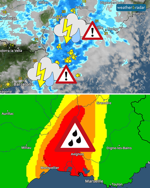
The WeatherRadar shows severe thunderstorms over the western Mediterranean. There is a high risk of severe weather.

The storm system is now moving on towards the south of France. From the southern Rhône Valley through the Cévennes to Provence, residents and holidaymakers should prepare for extreme rainfall. There is a risk of flash floods and rising water levels.

Weather & Radar editorial team
More on the topic
Severe weather in holiday spots. Crete and Spain. . . Thursday, 1 October 2026
Weather maps showing the risk of storms and flooding in Greece, as well as heavy rain and thunderstorms on Spain’s east coast.
Thursday, 1 October 2026

Crete and Spain

Severe weather in holiday spots
Hurricane POLO remains dangerous. Many storms in the Pacific. . . Thursday, 24 September 2026
Thursday, 24 September 2026

Many storms in the Pacific

Hurricane POLO remains dangerous
Weather contrasts over Europe. Low versus high. . . Tuesday, 29 September 2026
A powerful low-pressure system off Iceland is clashing with a stable high-pressure system over Scandinavia. Central Europe lies between them.
Tuesday, 29 September 2026

Low versus high

Weather contrasts over Europe
All weather news
This might also interest you
Flooding, gales, and heavy snow. Storm Chandra. . . Tuesday, 27 January 2026
Split image showing aerial flooding in a town with muddy water covering roads on the left, and a rural road on the right blocked by heavy snowfall with vans stopped and a person walking in snow.
Tuesday, 27 January 2026

Storm Chandra

Flooding, gales, and heavy snow
Storm Chandra makes impact. Severe gales & heavy rain. . . Tuesday, 27 January 2026
Split image showing strong winds over the UK on a forecast map and widespread rain and snow on a weather radar map.
Tuesday, 27 January 2026

Severe gales & heavy rain

Storm Chandra makes impact
New records for England and Wales. Broken again tomorrow?. . . Thursday, 25 June 2026
Temperature map of southwest Britain on 25.06 showing extreme heat across southern Wales and southwest England, with Bute Park in Cardiff highlighted at 34.2°C and Yeovilton at 36.4°C amid widespread deep red heat zones.
Thursday, 25 June 2026

Broken again tomorrow?

New records for England and Wales
All articles
Weather & Radar

Weather & Radar is also available on

Google Play StoreApp Store

Company

Contact us Privacy Policy Legal info Accessibility statement

Services

Uploader

Socials

facebooktwittertikToklinkList