Home
Weather London
WeatherRadar
RainfallRadar
TemperatureRadar
WindRadar
LightningRadar
Weather News
Editor's Pick
Discover the app
Weather widget
Contact us
Apps
Career
    Home / Editor's Pick /

    Gales again - Continued warnings to start the week

16:11
14 September 2025

Gales again
Continued warnings to start the week

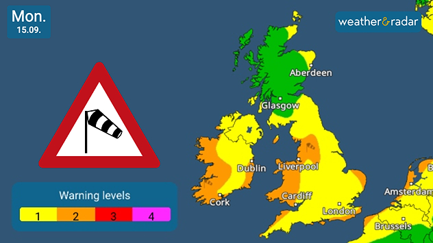
Alt text: Weather warning map for Monday, 15 September, showing wind risk levels across the UK and Ireland. Green areas indicate no warning, yellow areas (level 1) cover most of England, Wales, Northern Ireland, and southern Scotland, while orange areas (level 2) are shown in western Ireland and parts of western Wales. A wind warning symbol is displayed on the left.
Wide-ranging wind warnings for Monday.

The gusty conditions of Sunday persist into the start of the new week, with winds intensifying in places.

In-land, gusts of up to 50-55 mph are expected. There will be stronger gusts in coastal, exposed areas. While the conditions will be widespread across the UK and Ireland, Scotland will escape the worst of the day's winds.

There, gusts are only expected to reach highs of around 30 mph.

Heavy rain also returns in places, with thundery potential in north-west to northern England towards the afternoon.

Despite the conditions, the low-pressure system has not officially been named, therefore the wait for Storm Amy, and the first storm of the new season, continues.

Track current and forecasted conditionsread more
Ryan Hathaway
More on the topic
Hurricane Lowell threatens Hawaii. Gales and flash floods. . . Tuesday, 8 September 2026
WindRadar showing Hurricane Lowell north-west of Hawaii and its well-defined storm centre.
Tuesday, 8 September 2026

Gales and flash floods

Hurricane Lowell threatens Hawaii
Severe weather in the Mediterranean. Is a medicane on the way?. . . Monday, 14 September 2026
A weather map shows a powerful low-pressure system over the Mediterranean, with warning symbols for storms and heavy rain.
Monday, 14 September 2026

Is a medicane on the way?

Severe weather in the Mediterranean
Severe weather hits Mallorca and Italy. Severe thunderstorms. . . Thursday, 10 September 2026
Numerous thunderstorms are sweeping across La Palma. The many lightning symbols on the radar and lightning map show that there is heavy lightning activity across large parts of the island. The thunderstorms are striking particularly in the island’s interior and in the south. On the right, you can see the aftermath: a large fallen tree has buried a car beneath it. Emergency services are clearing up the damage. So, along with the thunderstorms, not only heavy rain but also gusts of wind can become a problem.
Thursday, 10 September 2026

Severe thunderstorms

Severe weather hits Mallorca and Italy
All weather news
This might also interest you
Seasonal warmth between spring thunder. Your weather - Your shots. . . Sunday, 19 April 2026
Split image showing coastal sunset with layered lenticular clouds over rooftops and palm trees on the left, and a green valley with river and hills under soft daylight on the right.
Sunday, 19 April 2026

Your weather - Your shots

Seasonal warmth between spring thunder
New records for England and Wales. Broken again tomorrow?. . . Thursday, 25 June 2026
Temperature map of southwest Britain on 25.06 showing extreme heat across southern Wales and southwest England, with Bute Park in Cardiff highlighted at 34.2°C and Yeovilton at 36.4°C amid widespread deep red heat zones.
Thursday, 25 June 2026

Broken again tomorrow?

New records for England and Wales
Storm Chandra makes impact. Severe gales & heavy rain. . . Tuesday, 27 January 2026
Split image showing strong winds over the UK on a forecast map and widespread rain and snow on a weather radar map.
Tuesday, 27 January 2026

Severe gales & heavy rain

Storm Chandra makes impact
All articles
Weather & Radar

Weather & Radar is also available on

Google Play StoreApp Store

Company

Contact us Privacy Policy Legal info Accessibility statement

Services

Uploader

Socials

facebooktwittertikToklinkList