Home
Weather London
WeatherRadar
RainfallRadar
TemperatureRadar
WindRadar
LightningRadar
Weather News
Editor's Pick
Discover the app
Weather widget
Contact us
Apps
Career
    Home / Editor's Pick /

    Full impact overnight - Early disruption ahead of Goretti

09:00
8 January 2026

Full impact overnight
Storm Goretti causing disruption

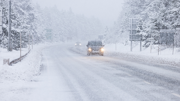
Cars driving slowly along a snow-covered road during heavy snowfall, with reduced visibility, snow-laden trees lining both sides, and headlights glowing through the wintry haze.
Heavy show has already blanketed the Scottish Highlands. - © picture alliance

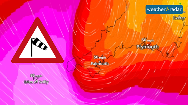
Storm Goretti has produced a record-high wind gust on the Isles of Scilly, amid wider adverse conditions bringing heavy snow.

Around 1,000 schools were closed across England and Scotland on Thursday due to poor travel conditions caused by recent snow and cold.

Multiple weather warnings are in effect, primarily for further snow and ice, Strong gales were also expected, with a gust of 99 mph at the Isles of Scilly's St. Mary's Airport a new record at the site.

Wind forecast map showing extreme winds around southwest England and the Isles of Scilly, with red and pink shading, streamlines, a windsock warning icon, and gusts up to 95 mph near coastal areas.
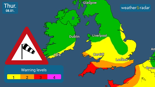
UK warning map dated Thu 08.01 showing wind warning levels with green, yellow, orange, and red shading across regions, a windsock warning icon, city labels, and a legend indicating levels 1 to 4.
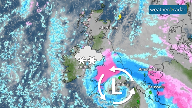
Night-time weather radar over the UK and western Europe showing blue and pink precipitation bands for rain and snow, a rotating low pressure system marked with an L over southern Britain.
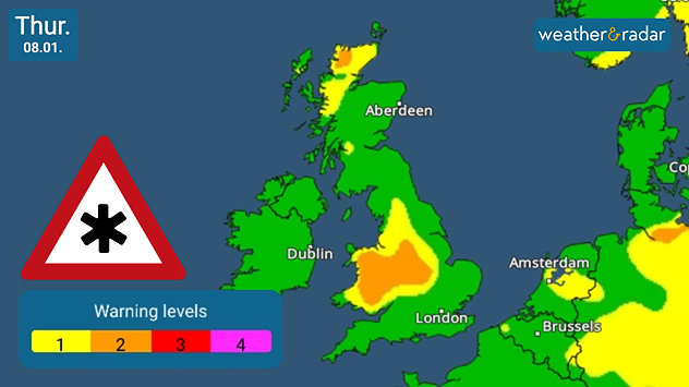
UK warning map dated Thu 08.01 showing snow and ice warning levels with green, yellow, and orange shading across regions, a snowflake warning icon, city labels, and a legend indicating levels 1 to 4.
1/4
Severe gales arrive in the far south-west Thursday evening.

For snow, Wales and the English Midlands are most likely to see the heaviest accumulations, with up to 30 cm possible in some areas.

National Rail has advised all passengers to double-check travel plans, particularly for Friday, with some lines seeing a reduced schedule from the afternoon. All trains running in Cornwall are set to be halted from 06:00 pm Thursday.

Why Goretti?

After Storm Bram in December, the next name in the 2025-26 storm list is Chandra. So why Goretti? The system was named by Météo-France. To help with consistency, any name given by a meteorological agency is adopted internationally.

Goretti brings only a glancing impact, with the system passing through southern England quickly en-route to Europe.

Norfolk feels coldest night of winterread more
Ryan Hathaway
More on the topic
Typhoon warning for China. Up to 500 mm of rain. . . Friday, 24 July 2026
Weather map of the southern Chinese coast and Taiwan showing a powerful tropical cyclone. The eye of the storm is located near the coastal city of Shantou in the Chinese province of Guangdong. Around the centre, intense shades of red, pink and violet indicate gale-force winds, whilst a large orange wind field extends as far as the west coast of Taiwan. An overlaid windsack warning sign indicates dangerous storm winds. Cities such as Hong Kong, Guangzhou, Xiamen, Taipei and Taichung are shown, as are wind speeds and white flow lines illustrating the cyclonic air circulation.
Friday, 24 July 2026

Up to 500 mm of rain

Typhoon warning for China
Heavier rainfall over the week for some. Ireland & Scotland. . . Tuesday, 28 July 2026
Split image showing a Europe rainfall accumulation forecast map on the left with the highest totals across the UK, Ireland, and Scandinavia, and a satellite weather map on the right with a broad band of rain stretching across Ireland, Scotland, and northern Britain, highlighted by a rain cloud icon.
Tuesday, 28 July 2026

Ireland & Scotland

Heavier rainfall over the week for some
Icy spells in the Southern Hemisphere. Snow in the Andes. . . Tuesday, 28 July 2026
A composite image showing a temperature radar map of South America and a snow-covered town in Chile. The winter cold is bringing heavy snowfall to the Andes and, in some areas, snow down to lower altitudes.
Tuesday, 28 July 2026

Snow in the Andes

Icy spells in the Southern Hemisphere
All weather news
This might also interest you
Storm Chandra makes impact. Severe gales & heavy rain. . . Tuesday, 27 January 2026
Split image showing strong winds over the UK on a forecast map and widespread rain and snow on a weather radar map.
Tuesday, 27 January 2026

Severe gales & heavy rain

Storm Chandra makes impact
Turbulent weather in the Canary Islands. Storm and rain. . . Friday, 12 December 2025
Weather graphic showing rain and wind fields over the Canary Islands and a central warning symbol.
Friday, 12 December 2025

Storm and rain

Turbulent weather in the Canary Islands
Bright and warm conditions take hold. Spring-like outlook. . . Thursday, 23 April 2026
Split UK map showing warm temperatures up to 21 degrees in orange on the left and clear sunny conditions with temperatures from 12 to 18 degrees on the right, with sun icons across the country.
Thursday, 23 April 2026

Spring-like outlook

Bright and warm conditions take hold
All articles
Weather & Radar

Weather & Radar is also available on

Google Play StoreApp Store

Company

Contact us Privacy Policy Legal info Accessibility statement

Services

Uploader

Socials

facebooktwittertikToklinkList