Home
Weather London
WeatherRadar
RainfallRadar
TemperatureRadar
WindRadar
LightningRadar
Weather News
Editor's Pick
Discover the app
Weather widget
Contact us
Apps
Career
    Home / Editor's Pick /

    Below -10 °C in areas - Coldest night of winter so far

09:00
6 January 2026

Below -10 °C in areas
Coldest night of winter so far

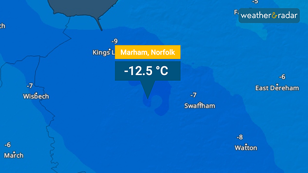
Temperature map of eastern England highlighting Marham, Norfolk at −12.5 °C, with surrounding areas shaded in deep blue and nearby locations labelled with subzero values.
An icy night in Norfolk where the lowest temperature of the year was felt in Marham.

A low of -12.5 °C in a Norfolk village overnight is the coldest temperature recorded this season so far.

The village of Marham saw the current seasonal record, with an Arctic chill also dropping temperatures to below -10 °C in the Scotland's Dalwhinnie (-11.2 °C) and Tulloch Bridge (-10.7 °C).

This chill was accompanied by heavy snow in places, resulting in school closures across parts of Scotland and Northern Ireland.

A temporary reprieve from the snow begins on Wednesday before stormy conditions take control later in the week.

Low-pressure brings stronger winds to southern areas of the UK and a return of rain and snow.

Storm front brings turbulent weatherread more
Ryan Hathaway
More on the topic
Autumn brings the first snow. Scandinavia turns white. . . Wednesday, 7 October 2026
Split screen. On the left, a weather map of Norway showing snow and rain. On the right: Scandinavia covered in snow.
Wednesday, 7 October 2026

Scandinavia turns white

Autumn brings the first snow
Much of Europe in storm mode. Twin low-pressure systems. . . Friday, 9 October 2026
WindRadar for Europe, showing wind speeds of up to 40 mph and wind socks over particularly windy regions.
Friday, 9 October 2026

Twin low-pressure systems

Much of Europe in storm mode
Wednesday washout for parts of England. Disruption possible. . . Tuesday, 6 October 2026
Weather map showing heavy rain from London through eastern England toward Norwich, with a flood warning symbol over East Anglia.
Tuesday, 6 October 2026

Disruption possible

Wednesday washout for parts of England
All weather news
This might also interest you
Storm Chandra makes impact. Severe gales & heavy rain. . . Tuesday, 27 January 2026
Split image showing strong winds over the UK on a forecast map and widespread rain and snow on a weather radar map.
Tuesday, 27 January 2026

Severe gales & heavy rain

Storm Chandra makes impact
Bright and warm conditions take hold. Spring-like outlook. . . Thursday, 23 April 2026
Split UK map showing warm temperatures up to 21 degrees in orange on the left and clear sunny conditions with temperatures from 12 to 18 degrees on the right, with sun icons across the country.
Thursday, 23 April 2026

Spring-like outlook

Bright and warm conditions take hold
New records for England and Wales. Broken again tomorrow?. . . Thursday, 25 June 2026
Temperature map of southwest Britain on 25.06 showing extreme heat across southern Wales and southwest England, with Bute Park in Cardiff highlighted at 34.2°C and Yeovilton at 36.4°C amid widespread deep red heat zones.
Thursday, 25 June 2026

Broken again tomorrow?

New records for England and Wales
All articles
Weather & Radar

Weather & Radar is also available on

Google Play StoreApp Store

Company

Contact us Privacy Policy Legal info Accessibility statement

Services

Uploader

Socials

facebooktwittertikToklinkList