Home
Weather London
WeatherRadar
RainfallRadar
TemperatureRadar
WindRadar
LightningRadar
Weather News
Editor's Pick
Discover the app
Weather widget
Contact us
Apps
Career
    Home / Editor's Pick /

    From 25, to 5 degrees - USA: Temperatures are up and down

10:00
31 March 2026

From 25, to 5 degrees
USA: Temperatures are up and down

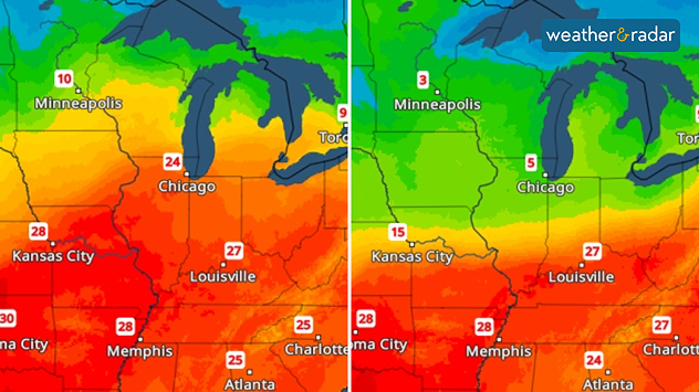
A sharp drop in temperature is on the way in parts of the US. Today, Chicago is still hovering around 25 degrees, but tomorrow temperatures will suddenly plummet to around 5 degrees.

A sharp drop in temperatures is on the way in the US. Maximum temperatures for today (left) and tomorrow (right).

After that, the temperature will shoot back up again, just like on a rollercoaster. By Thursday, the thermometer will be showing around 20 degrees again.

Chicago

Mo
11
23
Tu
12
25
We
17
23
Th
19
22
Fr
14
19
Sa
12
19
Su
12
20
Mo
13
17
Tu
10
18
We
11
19
Th
12
17
Fr
10
15
Sa
10
18
Su
10
18
Max (°C)
Min (°C)
moreless

New York

Mo
14
18
Tu
17
22
We
17
24
Th
19
27
Fr
21
29
Sa
17
19
Su
13
20
Mo
16
20
Tu
14
21
We
14
21
Th
15
19
Fr
14
19
Sa
12
20
Su
13
21
Max (°C)
Min (°C)
moreless

Boston

Mo
13
15
Tu
13
19
We
15
20
Th
14
27
Fr
20
28
Sa
15
18
Su
10
18
Mo
13
18
Tu
13
18
We
9
19
Th
11
19
Fr
10
18
Sa
10
18
Su
10
19
Max (°C)
Min (°C)
moreless

Philadelphia

Mo
16
19
Tu
17
23
We
15
25
Th
18
28
Fr
20
31
Sa
18
18
Su
13
21
Mo
17
21
Tu
15
23
We
13
21
Th
15
22
Fr
13
21
Sa
12
20
Su
13
21
Max (°C)
Min (°C)
moreless

Of course, this sudden drop in temperature won’t come without consequences. Things are set to get pretty rough, particularly in Iowa and northern Illinois: expect severe thunderstorms with heavy rain, hail and gusts of wind, and even the odd supercell.

On Thursday, the cold snap will reach the east coast: temperatures in New York will drop to 8 degrees, whilst in Boston they’ll be as low as a mere 4 degrees.

Glossary: What is a supercell?read more
Sebastian Keßler
More on the topic
Equinox marks the start of autumn. Days start to get shorter. . . Wednesday, 23 September 2026
Split image showing Stonehenge in warm sunlight beside a tree-lined park glowing with vivid orange, red, and golden autumn leaves.
Wednesday, 23 September 2026

Days start to get shorter

Equinox marks the start of autumn
Warm weather despite the start of autumn. Temperatures worldwide. . . Wednesday, 23 September 2026
Temperature Radar for the Northern Hemisphere
Wednesday, 23 September 2026

Temperatures worldwide

Warm weather despite the start of autumn
Colourful skies and scenic clouds cover. Your weather - Your shots. . . Sunday, 20 September 2026
Split image showing a golden sunset over the sea beneath layered clouds and a pink-purple sunset reflected across calm riverside water.
Sunday, 20 September 2026

Your weather - Your shots

Colourful skies and scenic clouds cover
All weather news
This might also interest you
Bright and warm conditions take hold. Spring-like outlook. . . Thursday, 23 April 2026
Split UK map showing warm temperatures up to 21 degrees in orange on the left and clear sunny conditions with temperatures from 12 to 18 degrees on the right, with sun icons across the country.
Thursday, 23 April 2026

Spring-like outlook

Bright and warm conditions take hold
Storm Chandra makes impact. Severe gales & heavy rain. . . Tuesday, 27 January 2026
Split image showing strong winds over the UK on a forecast map and widespread rain and snow on a weather radar map.
Tuesday, 27 January 2026

Severe gales & heavy rain

Storm Chandra makes impact
Super Typhoon Bavi threatens Taiwan. Up to 1,000 mm of rain. . . Wednesday, 8 July 2026
The image shows an intense tropical cyclone over the western Pacific, east of Taiwan and the Philippines. The centre of the system is depicted as a light purple and white vortex with a clearly visible eye, surrounded by a ring of red and orange areas indicating the strongest wind speeds. A white arrow marks the typhoon’s predicted track towards the north-west, in the direction of Taiwan. To the west of the storm lie the Philippines, with the cities of Manila and Cebu; to the north of these lies Taiwan, with Taipei. Further west, the Chinese coast, including Hong Kong, and parts of Vietnam can be seen. The coloured wind map shows predominantly green areas outside the storm’s core, indicating significantly weaker winds. White streamlines illustrate the typhoon’s anti-clockwise circulation in the Northern Hemisphere. The highest wind speeds are concentrated around the eye of the cyclone.
Wednesday, 8 July 2026

Up to 1,000 mm of rain

Super Typhoon Bavi threatens Taiwan
All articles
Weather & Radar

Weather & Radar is also available on

Google Play StoreApp Store

Company

Contact us Privacy Policy Legal info Accessibility statement

Services

Uploader

Socials

facebooktwittertikToklinkList