Home
Weather London
WeatherRadar
RainfallRadar
TemperatureRadar
WindRadar
LightningRadar
Weather News
Editor's Pick
Discover the app
Weather widget
Contact us
Apps
Career
    Home / Editor's Pick /

    Ex-hurricane GABRIELLE reaches western Mediterranean – risk of flooding due to severe thunderstorms

09:00
29 September 2025

Severe thunderstorms
Ex-hurricane in the western Mediterranean

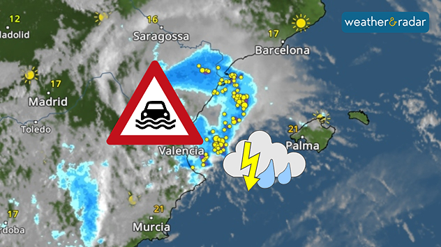
Severe thunderstorms with heavy rain on Spain's Mediterranean coast: Valencia particularly at risk of flooding.

Ex-Hurricane GABRIELLE has reached the western Mediterranean and will bring heavy rainfall, particularly along the east coast of Spain and the Balearic Islands, until Tuesday evening.

Flood risk

The province of Valencia in particular is experiencing torrential rainfall of 200 to 300 litres per square metre, with peaks even higher. Fortunately, most of the rain is falling over the open sea. By way of comparison, the city of Valencia receives an average of around 480 litres over the course of a whole year.

The popular holiday islands of Ibiza and Mallorca will also experience turbulent weather. Severe thunderstorms could also bring heavy rainfall here.

This is how showers and thunderstorms move inDevelopment in the weather radar

On Sunday evening, severe weather struck the area around Zaragoza in north-eastern Spain. Flash floods swept away cars and caused devastating damage.

Late in the evening, the first rainfall reached the coastal city of Valencia:

Kathrin Bogensperger
More on the topic
Heat becoming a bigger factor in drought. New study. . . Thursday, 23 July 2026
A hand holds dry, dusty earth above a parched field. The ground is cracked and covered with plant debris – a sign of prolonged drought.
Thursday, 23 July 2026

New study

Heat becoming a bigger factor in drought
Drought for North Wales and Upper Severn. 2% of average rainfall. . . Thursday, 23 July 2026
Split image showing a July rainfall anomaly map of Europe on the left with below-average rainfall across the UK, Ireland, and much of western and central Europe, and an active moorland wildfire on the right producing flames and thick smoke near homes.
Thursday, 23 July 2026

2% of average rainfall

Drought for North Wales and Upper Severn
Heatwave breaks after remarkable run. Two weeks of heat. . . Monday, 20 July 2026
Split image showing the London skyline in hazy golden sunshine on the left and a July temperature anomaly map of Europe on the right, with above-average temperatures across the UK, Ireland, and much of western Europe highlighted in red alongside a thermometer icon.
Monday, 20 July 2026

Two weeks of heat

Heatwave breaks after remarkable run
All weather news
This might also interest you
Flooding, gales, and heavy snow. Storm Chandra. . . Tuesday, 27 January 2026
Split image showing aerial flooding in a town with muddy water covering roads on the left, and a rural road on the right blocked by heavy snowfall with vans stopped and a person walking in snow.
Tuesday, 27 January 2026

Storm Chandra

Flooding, gales, and heavy snow
Seasonal warmth between spring thunder. Your weather - Your shots. . . Sunday, 19 April 2026
Split image showing coastal sunset with layered lenticular clouds over rooftops and palm trees on the left, and a green valley with river and hills under soft daylight on the right.
Sunday, 19 April 2026

Your weather - Your shots

Seasonal warmth between spring thunder
Storm Chandra makes impact. Severe gales & heavy rain. . . Tuesday, 27 January 2026
Split image showing strong winds over the UK on a forecast map and widespread rain and snow on a weather radar map.
Tuesday, 27 January 2026

Severe gales & heavy rain

Storm Chandra makes impact
All articles
Weather & Radar

Weather & Radar is also available on

Google Play StoreApp Store

Company

Contact us Privacy Policy Legal info Accessibility statement

Services

Uploader

Socials

facebooktwittertikToklinkList