Home
Weather London
WeatherRadar
RainfallRadar
TemperatureRadar
WindRadar
LightningRadar
Weather News
Editor's Pick
Discover the app
Weather widget
Contact us
Apps
Career
    Home / Editor's Pick /

    Severe thunderstorms - Turbulent conditions in southern Europe

10:00
24 August 2026

Severe thunderstorms
Turbulent conditions in southern Europe

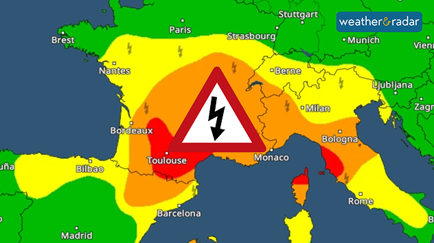
A rather precarious weather situation is developing from northern Spain through France to northern Italy.

A powerful thunderstorm front forms Monday afternoon from the Pyrenees to central France and will then move eastwards.

During the night leading into Tuesday, the thunderstorms will reach northern Italy and southern Switzerland before moving on towards the Adriatic.

Risk of severe weather from the Pyrenees to the Adriatic.

There is a significant risk of severe weather in the affected areas. The thunderstorms are bringing heavy rain, large hailstones, and gale-force gusts.

Roads may become flooded, trees may be uprooted, and in mountainous regions, landslides are even possible.

Follow the thunderstormsWeatherRadar
Weather & Radar editorial team
More on the topic
Drought brings flash flood risks. As rain returns. . . Wednesday, 19 August 2026
Weather radar map of the UK and Ireland showing widespread showers, with a rain icon and flood warning symbol highlighting the risk from rainfall.
Wednesday, 19 August 2026

As rain returns

Drought brings flash flood risks
Lightning strikes in dry conditions. Positive earth flashes. . . Monday, 17 August 2026
On the left, massive thunderclouds are gathering at night, with several flashes of lightning streaking from them. On the right, a map shows the Ligurian coast near Genoa and Savona. Numerous coloured dots over the Ligurian Sea and along the coast indicate lightning activity.
Monday, 17 August 2026

Positive earth flashes

Lightning strikes in dry conditions
Chance of thundery showers breaking out. Over the coming days. . . Tuesday, 18 August 2026
Split weather graphic showing a yellow thunderstorm warning across eastern England alongside radar with heavy showers and lightning near Sheffield, Leicester and East Anglia.
Tuesday, 18 August 2026

Over the coming days

Chance of thundery showers breaking out
All weather news
This might also interest you
Historic Storm Éowyn arrives. On this day.... . . Saturday, 24 January 2026
Split image showing a person in a yellow jacket struggling against strong winds and heavy rain on a street at night on the left, and an Irish wind forecast map on the right with red and purple shading, gusts up to 75 mph, and a wind warning icon, divided by a curved white line.
Saturday, 24 January 2026

On this day...

Historic Storm Éowyn arrives
Flooding, gales, and heavy snow. Storm Chandra. . . Tuesday, 27 January 2026
Split image showing aerial flooding in a town with muddy water covering roads on the left, and a rural road on the right blocked by heavy snowfall with vans stopped and a person walking in snow.
Tuesday, 27 January 2026

Storm Chandra

Flooding, gales, and heavy snow
Turbulent weather in the Canary Islands. Storm and rain. . . Friday, 12 December 2025
Weather graphic showing rain and wind fields over the Canary Islands and a central warning symbol.
Friday, 12 December 2025

Storm and rain

Turbulent weather in the Canary Islands
All articles
Weather & Radar

Weather & Radar is also available on

Google Play StoreApp Store

Company

Contact us Privacy Policy Legal info Accessibility statement

Services

Uploader

Socials

facebooktwittertikToklinkList