Home
Weather London
WeatherRadar
RainfallRadar
TemperatureRadar
WindRadar
LightningRadar
Weather News
Editor's Pick
Discover the app
Weather widget
Contact us
Apps
Career
    Home / Editor's Pick /

    First major storm of the season - Storm Austen named

10:00
20 October 2026

Storm Austen named
First major storm of the season

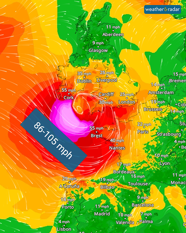
Storm Austen is set to bring severe weather from Thursday evening. Gale-force gusts and heavy rain is expected.

The storm system is currently expected to move through southern England, with gusts of up to 70 mph in the south-west, including Plymouth. The conditions will also reach western Europe, keep an eye on that if you have a holiday planned this half-term.

Trees may topple, damaging properties and vehicles. It will also cause problems for travellers: flights and ferries may be cancelled, and rail services are likely to be disrupted.

WindRadar: Severe gale-force winds are forecast over the Atlantic on Thursday evening.

The change begins on Thursday evening, with stormy weather stretching from Ireland, through the UK, into Brittany. Northern Spain will also feel the effects of the storm. On Friday, it will mainly affect the UK, the English Channel and northern France.

In isolated cases, hurricane-force gusts of around 95 miles per hour are even possible. Rainfall accumulations of 20 to 30 mm are also expected widely. Weather warnings for wind and rain are already live.

Severe weather warnings are activeread more
Weather & Radar editorial team

More on the topic

South-east saw a record-breaking drought. Rain coming but not enough. . . Thursday, 15 October 2026
Split graphic showing yellow rainfall deficit areas across the UK and Ireland beside a dry, parched landscape with two people walking.
Thursday, 15 October 2026

Rain coming but not enough

South-east saw a record-breaking drought
Warnings live across the UK and Ireland. How do they work?. . . Tuesday, 20 October 2026
Weather warning map showing yellow and orange wind alerts across Ireland and England, with red level 3 areas in southwest England and a windsock symbol.
Tuesday, 20 October 2026

How do they work?

Warnings live across the UK and Ireland
Both chilly and mild overnight. Temperature split. . . Thursday, 15 October 2026
Temperature map showing 4°C near Aberdeen, 7°C in Dublin, 10°C in Liverpool, and 15°C in London, with blue and red thermometer symbols indicating cold and mild areas.
Thursday, 15 October 2026

Temperature split

Both chilly and mild overnight
All weather news

This might also interest you

Storm Chandra makes impact. Severe gales & heavy rain. . . Tuesday, 27 January 2026
Split image showing strong winds over the UK on a forecast map and widespread rain and snow on a weather radar map.
Tuesday, 27 January 2026

Severe gales & heavy rain

Storm Chandra makes impact
A frozen start to the weekend. Icy conditions. . . Friday, 13 February 2026
UK temperature map dated 14.02 showing widespread subzero values in blue shading, with readings such as −4 in Glasgow, −3 in Dublin, and −2 in London, alongside a blue thermometer icon.
Friday, 13 February 2026

Icy conditions

A frozen start to the weekend
New records for England and Wales. Broken again tomorrow?. . . Thursday, 25 June 2026
Temperature map of southwest Britain on 25.06 showing extreme heat across southern Wales and southwest England, with Bute Park in Cardiff highlighted at 34.2°C and Yeovilton at 36.4°C amid widespread deep red heat zones.
Thursday, 25 June 2026

Broken again tomorrow?

New records for England and Wales
All articles
Weather & Radar

Weather & Radar is also available on

Google Play StoreApp Store

Company

Contact us Privacy Policy Legal info Accessibility statement

Services

Uploader

Socials

facebooktwittertikToklinkList