Home
Weather London
WeatherRadar
RainfallRadar
TemperatureRadar
WindRadar
LightningRadar
Weather News
Editor's Pick
Discover the app
Weather widget
Contact us
Apps
Career
    Home / Editor's Pick /

    Disruption possible - Wednesday washout for parts of England

15:13
6 October 2026

Disruption possible
Wednesday washout for parts of England

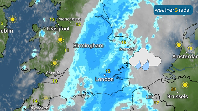
Heavy and persistent rain settles into parts of England on Wednesday.

Raincoats and umbrellas at the ready for Wednesday, parts of England will face a washout thanks to the influence of a cold front meeting low pressure.

From central to eastern and south-eastern England, Wednesday will see persistent, and at times heavy, rain throughout the day.

It comes as a cold front, which pushed through the UK on Tuesday, meets a developing area of low pressure over the Bay of Biscay. Rain begins overnight, becoming more prolonged in the new day.

The low pressure also brings growing gusts later in the day, not just confined to south-east England but across Wales and Ireland by the afternoon too.

With such persistent rain in the region, surface flooding is possible impacting road travel. Environment Agency guidance suggests a risk of property flooding in those areas under the rainfall.

Keep an eye on the rain as it builds and sustains on the WeatherRadar.

Ryan Hathaway
More on the topic
Weather contrasts over Europe. Low versus high. . . Tuesday, 29 September 2026
A powerful low-pressure system off Iceland is clashing with a stable high-pressure system over Scandinavia. Central Europe lies between them.
Tuesday, 29 September 2026

Low versus high

Weather contrasts over Europe
Sunset views mark the start of the month. Your weather - Your shots. . . Sunday, 4 October 2026
Split image showing offshore wind turbines beneath a pink-purple sky and a fiery red-orange sunset above silhouetted rooftops.
Sunday, 4 October 2026

Your weather - Your shots

Sunset views mark the start of the month
First autumn views of the season. Your weather - Your shots. . . Sunday, 27 September 2026
Split image showing a vivid double rainbow over green fields beside a sunny marina filled with boats beneath blue skies.
Sunday, 27 September 2026

Your weather - Your shots

First autumn views of the season
All weather news
This might also interest you
Historic Storm Éowyn arrives. On this day.... . . Saturday, 24 January 2026
Split image showing a person in a yellow jacket struggling against strong winds and heavy rain on a street at night on the left, and an Irish wind forecast map on the right with red and purple shading, gusts up to 75 mph, and a wind warning icon, divided by a curved white line.
Saturday, 24 January 2026

On this day...

Historic Storm Éowyn arrives
A frozen start to the weekend. Icy conditions. . . Friday, 13 February 2026
UK temperature map dated 14.02 showing widespread subzero values in blue shading, with readings such as −4 in Glasgow, −3 in Dublin, and −2 in London, alongside a blue thermometer icon.
Friday, 13 February 2026

Icy conditions

A frozen start to the weekend
Seasonal warmth between spring thunder. Your weather - Your shots. . . Sunday, 19 April 2026
Split image showing coastal sunset with layered lenticular clouds over rooftops and palm trees on the left, and a green valley with river and hills under soft daylight on the right.
Sunday, 19 April 2026

Your weather - Your shots

Seasonal warmth between spring thunder
All articles
Weather & Radar

Weather & Radar is also available on

Google Play StoreApp Store

Company

Contact us Privacy Policy Legal info Accessibility statement

Services

Uploader

Socials

facebooktwittertikToklinkList