Home
Weather London
WeatherRadar
RainfallRadar
TemperatureRadar
WindRadar
LightningRadar
Weather News
Editor's Pick
Discover the app
Weather widget
Contact us
Apps
Career
    Home / Editor's Pick /

    Deluge starts the week - Flood warnings with heavy rain arriving

09:00
8 February 2026

Deluge starts the week
Flood warnings with heavy rain arriving

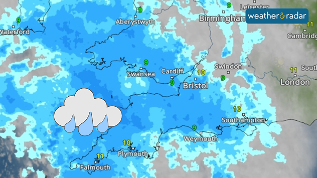
Monday sees heavy rain settle in.

Flood warnings are live across the UK, with a focus in the south-west where heavy rain will fall over saturated ground on Monday.

There are currently 88 flood warnings, indicating flooding is expected, primarily in the south-west and stretching into the English Midlands.

An additional 223 flood alerts, where flooding is possible, have also been issued by the Environment Agency.

Changing warnings

Flood warnings are a live service, the number active may have changed. Check warnings near you for the latest.

Up to 30 mm of rain is expected in areas exposed to southeasterly winds, with around 15 mm in other areas.

After Monday's deluge, further heavy rain is expected to arrive on Tuesday exacerbating issues with saturated ground unable to absorb the water.

Keep an eye on the WeatherRadar for the latest conditions around you.

Ryan Hathaway
More on the topic
Heat becoming a bigger factor in drought. New study. . . Thursday, 23 July 2026
A hand holds dry, dusty earth above a parched field. The ground is cracked and covered with plant debris – a sign of prolonged drought.
Thursday, 23 July 2026

New study

Heat becoming a bigger factor in drought
Fourth heatwave of the year. Peaking Wednesday. . . Tuesday, 28 July 2026
Temperature map of England and Wales on Wednesday 29.07 showing widespread hot conditions, with temperatures reaching 33°C near Cambridge, 32°C around London, Norwich, and Southend-on-Sea, and a large heat warning symbol highlighting elevated heat risk.
Tuesday, 28 July 2026

Peaking Wednesday

Fourth heatwave of the year
Drought for North Wales and Upper Severn. 2% of average rainfall. . . Thursday, 23 July 2026
Split image showing a July rainfall anomaly map of Europe on the left with below-average rainfall across the UK, Ireland, and much of western and central Europe, and an active moorland wildfire on the right producing flames and thick smoke near homes.
Thursday, 23 July 2026

2% of average rainfall

Drought for North Wales and Upper Severn
All weather news
This might also interest you
A frozen start to the weekend. Icy conditions. . . Friday, 13 February 2026
UK temperature map dated 14.02 showing widespread subzero values in blue shading, with readings such as −4 in Glasgow, −3 in Dublin, and −2 in London, alongside a blue thermometer icon.
Friday, 13 February 2026

Icy conditions

A frozen start to the weekend
Seasonal warmth between spring thunder. Your weather - Your shots. . . Sunday, 19 April 2026
Split image showing coastal sunset with layered lenticular clouds over rooftops and palm trees on the left, and a green valley with river and hills under soft daylight on the right.
Sunday, 19 April 2026

Your weather - Your shots

Seasonal warmth between spring thunder
Bright and warm conditions take hold. Spring-like outlook. . . Thursday, 23 April 2026
Split UK map showing warm temperatures up to 21 degrees in orange on the left and clear sunny conditions with temperatures from 12 to 18 degrees on the right, with sun icons across the country.
Thursday, 23 April 2026

Spring-like outlook

Bright and warm conditions take hold
All articles
Weather & Radar

Weather & Radar is also available on

Google Play StoreApp Store

Company

Contact us Privacy Policy Legal info Accessibility statement

Services

Uploader

Socials

facebooktwittertikToklinkList