Home
Weather London
WeatherRadar
RainfallRadar
TemperatureRadar
WindRadar
LightningRadar
Weather News
Editor's Pick
Discover the app
Weather widget
Contact us
Apps
Career
    Home / Editor's Pick /

    Tips to beat the heat - Getting through the latest heatwave

10:43
11 August 2026

Tips to beat the heat
Getting through the latest heatwave

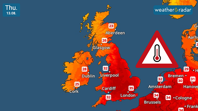
Temperatures peak Thursday with highs around 37°C.

Amid the fifth heatwave of the year, the days ahead can become uncomfortable quickly. Here's just a few ways you can try to alleviate the worst of the impacts.

With amber extreme heat warnings covering parts of England, and yellow heat warnings in central to eastern Ireland, highs of around 37°C are expected, peaking on Thursday.

During this, staying hydrated is paramount. Ensure you have access to plenty of fresh drinking water for yourself and any pets, spray bottles can be used to spray the face for relief.

As well as keeping an eye on the UV Index in the app, applying, and remembering to regularly reapply, sun cream during the hot spell is of utmost importance. Even more so if working or spending time outdoors under the sunshine.

Peak sunshine hours occur between 11:00 am and 03:00 pm, during this time it is recommended to keep blinds, curtains, and windows closed to curtail the heating effect in buildings.

Safety in the water

A trip to the seaside or other bodies of water are tempting in the heat but also bring danger. Enter the water slowly and avoid diving in to prevent cold water shock.

The latest forecast shows tropical nights in places, including Manchester and London, with temperatures of 20°C and above overnight. This makes for uncomfortable sleeping conditions, though there are some tips to try and ease this.

Ryan Hathaway
More on the topic
Stronger winds make a return. Low pressure influence. . . Tuesday, 4 August 2026
Wind forecast map of the UK and Ireland showing a low-pressure system north of Scotland, a windsock icon highlighting blustery conditions, and widespread winds of 30–40 mph across the British Isles, with the strongest winds around Ireland and northern Britain.
Tuesday, 4 August 2026

Low pressure influence

Stronger winds make a return
More comfortable night's sleep. Overnight low drops. . . Wednesday, 5 August 2026
Morning temperature map of the UK and Ireland showing cool conditions, with temperatures ranging from 7°C in South Wales to 13°C in southeast England. Ireland records 9–12°C, while much of England and Wales is between 8°C and 10°C. A blue thermometer icon highlights the cooler weather.
Wednesday, 5 August 2026

Overnight low drops

More comfortable night's sleep
Cooler nights on the horizon. For parts of Europe. . . Thursday, 6 August 2026
Temperature Radar showing the night-time lows in Central Europe. Cooler air is reaching the west and north in particular, whilst the south-east remains significantly warmer.
Thursday, 6 August 2026

For parts of Europe

Cooler nights on the horizon
All weather news
This might also interest you
Long-term trends need a pinch of salt. 40 °C in July?. . . Tuesday, 30 June 2026
Temperature radar of 2022 heatwave where the all-time temperature record in the UK was set. Warning symbol overlain.
Tuesday, 30 June 2026

40 °C in July?

Long-term trends need a pinch of salt
Super Typhoon Bavi threatens Taiwan. Up to 1,000 mm of rain. . . Wednesday, 8 July 2026
The image shows an intense tropical cyclone over the western Pacific, east of Taiwan and the Philippines. The centre of the system is depicted as a light purple and white vortex with a clearly visible eye, surrounded by a ring of red and orange areas indicating the strongest wind speeds. A white arrow marks the typhoon’s predicted track towards the north-west, in the direction of Taiwan. To the west of the storm lie the Philippines, with the cities of Manila and Cebu; to the north of these lies Taiwan, with Taipei. Further west, the Chinese coast, including Hong Kong, and parts of Vietnam can be seen. The coloured wind map shows predominantly green areas outside the storm’s core, indicating significantly weaker winds. White streamlines illustrate the typhoon’s anti-clockwise circulation in the Northern Hemisphere. The highest wind speeds are concentrated around the eye of the cyclone.
Wednesday, 8 July 2026

Up to 1,000 mm of rain

Super Typhoon Bavi threatens Taiwan
Historic Storm Éowyn arrives. On this day.... . . Saturday, 24 January 2026
Split image showing a person in a yellow jacket struggling against strong winds and heavy rain on a street at night on the left, and an Irish wind forecast map on the right with red and purple shading, gusts up to 75 mph, and a wind warning icon, divided by a curved white line.
Saturday, 24 January 2026

On this day...

Historic Storm Éowyn arrives
All articles
Weather & Radar

Weather & Radar is also available on

Google Play StoreApp Store

Company

Contact us Privacy Policy Legal info Accessibility statement

Services

Uploader

Socials

facebooktwittertikToklinkList