Home
Weather London
WeatherRadar
RainfallRadar
TemperatureRadar
WindRadar
LightningRadar
Weather News
Editor's Pick
Discover the app
Weather widget
Contact us
Apps
Career
    Home / Editor's Pick /

    Dangerous thunderstorm front over the US – tornadoes, giant hailstones and flooding possible

10:00
18 May 2026

Tornadoes possible
Dangerous thunderstorm front over the US

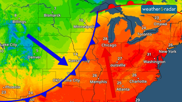
From the Rockies across the Great Plains to the Great Lakes, a dangerous storm system is building up. A cold front is triggering turbulent weather with many severe thunderstorms.

Numerous lightning strikes in the MidwestLightningRadar US

Conditions will be particularly severe from Kansas to south-eastern Nebraska. Supercells may form there, producing giant hailstones and powerful tornadoes. These are long-lived, rotating thunderstorm cells with strong updrafts.

TemperatureRadar: A cold front over the US is sweeping away the summer air.

At the same time, warm, moist air is flowing far northwards from the Gulf of Mexico. Meanwhile, cooler air is moving in from the north-west, providing the thunderstorms with additional energy.

As well as tornadoes, there is also a risk of heavy downpours, strong gusts of wind and localised flooding. Conditions may remain unsettled in some regions until Wednesday.

Tommy Kühnlein
More on the topic
A wet start before conditions settle. Commonwealth Games 2026. . . Wednesday, 22 July 2026
Split image showing a weather map for western Scotland with widespread rain around Glasgow on the left, and runners poised at a starting line on an athletics track on the right.
Wednesday, 22 July 2026

Commonwealth Games 2026

A wet start before conditions settle
Drought for North Wales and Upper Severn. 2% of average rainfall. . . Thursday, 23 July 2026
Split image showing a July rainfall anomaly map of Europe on the left with below-average rainfall across the UK, Ireland, and much of western and central Europe, and an active moorland wildfire on the right producing flames and thick smoke near homes.
Thursday, 23 July 2026

2% of average rainfall

Drought for North Wales and Upper Severn
Long-term trends need a pinch of salt. Heading over 40°C?. . . Tuesday, 21 July 2026
Temperature radar of 2022 heatwave where the all-time temperature record in the UK was set. Warning symbol overlain.
Tuesday, 21 July 2026

Heading over 40°C?

Long-term trends need a pinch of salt
All weather news
This might also interest you
Bright and warm conditions take hold. Spring-like outlook. . . Thursday, 23 April 2026
Split UK map showing warm temperatures up to 21 degrees in orange on the left and clear sunny conditions with temperatures from 12 to 18 degrees on the right, with sun icons across the country.
Thursday, 23 April 2026

Spring-like outlook

Bright and warm conditions take hold
Flooding, gales, and heavy snow. Storm Chandra. . . Tuesday, 27 January 2026
Split image showing aerial flooding in a town with muddy water covering roads on the left, and a rural road on the right blocked by heavy snowfall with vans stopped and a person walking in snow.
Tuesday, 27 January 2026

Storm Chandra

Flooding, gales, and heavy snow
Historic Storm Éowyn arrives. On this day.... . . Saturday, 24 January 2026
Split image showing a person in a yellow jacket struggling against strong winds and heavy rain on a street at night on the left, and an Irish wind forecast map on the right with red and purple shading, gusts up to 75 mph, and a wind warning icon, divided by a curved white line.
Saturday, 24 January 2026

On this day...

Historic Storm Éowyn arrives
All articles
Weather & Radar

Weather & Radar is also available on

Google Play StoreApp Store

Company

Contact us Privacy Policy Legal info Accessibility statement

Services

Uploader

Socials

facebooktwittertikToklinkList