Home
Weather London
WeatherRadar
RainfallRadar
TemperatureRadar
WindRadar
LightningRadar
Weather News
Editor's Pick
Discover the app
Weather widget
Contact us
Apps
Career
    Home / Editor's Pick /

    Damage and fatalities: Typhoon RAGASA wreaks havoc in Southeast Asia

09:40
24 September 2025

Damage and fatalities
Typhoon RAGASA rages in Southeast Asia

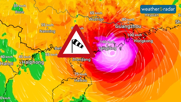
WindRadar shows wind speeds exceeding 150 kilometres per hour on the coast of China
WindRadar: Typhoon RAGASA hits the south coast of China with wind speeds between 150 and 200 kilometres per hour.

Super Typhoon RAGASA has now reached Hong Kong and China in Southeast Asia, bringing with it strong winds and heavy rainfall. It had previously caused severe damage in the Philippines and Taiwan, claiming the lives of over 20 people.

There, it made landfall with wind speeds of over 200 kilometres per hour in some areas. High waves caused flooding along the coast.

Today, the cyclone is hitting southern China as a typhoon of the second-highest category. In the densely populated coastal province of Guangdong, more than a million people have been brought to safety since yesterday. In neighbouring Hong Kong, too, public life has largely come to a standstill.

The typhoon remains very dangerous because it will initially continue to move westward along the Chinese coast and only then slowly weaken over land.

Super Typhoon RAGASA continues to move onWindRadar
Dr. Bernd Maurer
More on the topic
Long-term trends need a pinch of salt. Heading over 40°C?. . . Tuesday, 21 July 2026
Temperature radar of 2022 heatwave where the all-time temperature record in the UK was set. Warning symbol overlain.
Tuesday, 21 July 2026

Heading over 40°C?

Long-term trends need a pinch of salt
Drought across large parts of Europe. High fire risk. . . Monday, 20 July 2026
Split image showing a Europe rainfall anomaly map on the left with widespread dry conditions across much of the continent, and a cracked, parched field on the right alongside a wildfire warning symbol highlighting elevated fire risk.
Monday, 20 July 2026

High fire risk

Drought across large parts of Europe
Rain returns to end dry spell in places. Jet stream delivery. . . Thursday, 23 July 2026
Split weather graphic showing widespread showers across the UK and Ireland on the left, and a wind forecast map on the right with a windsock icon and gusts of 25 to 35 mph, highlighting breezy conditions across the two countries.
Thursday, 23 July 2026

Jet stream delivery

Rain returns to end dry spell in places
All weather news
This might also interest you
Storm Chandra makes impact. Severe gales & heavy rain. . . Tuesday, 27 January 2026
Split image showing strong winds over the UK on a forecast map and widespread rain and snow on a weather radar map.
Tuesday, 27 January 2026

Severe gales & heavy rain

Storm Chandra makes impact
Long-term trends need a pinch of salt. 40 °C in July?. . . Tuesday, 30 June 2026
Temperature radar of 2022 heatwave where the all-time temperature record in the UK was set. Warning symbol overlain.
Tuesday, 30 June 2026

40 °C in July?

Long-term trends need a pinch of salt
Seasonal warmth between spring thunder. Your weather - Your shots. . . Sunday, 19 April 2026
Split image showing coastal sunset with layered lenticular clouds over rooftops and palm trees on the left, and a green valley with river and hills under soft daylight on the right.
Sunday, 19 April 2026

Your weather - Your shots

Seasonal warmth between spring thunder
All articles
Weather & Radar

Weather & Radar is also available on

Google Play StoreApp Store

Company

Contact us Privacy Policy Legal info Accessibility statement

Services

Uploader

Socials

facebooktwittertikToklinkList