Home
Weather London
WeatherRadar
RainfallRadar
TemperatureRadar
WindRadar
LightningRadar
Weather News
Editor's Pick
Discover the app
Weather widget
Contact us
Apps
Career
    Home / Editor's Pick /

    Cyclone hits Australia's west coast – Narelle continues to rage

11:00
27 March 2026

Narelle continues to rage
Cyclone on Australia’s west coast

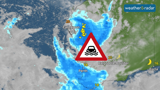
A tropical cyclone named Narelle is currently bringing dangerous weather to Australia’s west coast. The cyclone has made landfall near the small town of Exmouth, already causing damage.

Narelle remains very powerful, with gusts of up to around 110 miles per hour, and is still classified as a Category 3 storm. It is now threatening the town of Carnarvon. There is a risk of damage from falling trees, roofs being blown off and high waves.

WeatherRadar: The cyclone will weaken by Saturday, but will still bring heavy rain and thunderstorms.

The cyclone is also bringing heavy rain. Flash floods and severe flooding are possible. Although Narelle is weakening rapidly, the rain is set to continue. It may also reach areas further south, such as the city of Perth, which has a population of over a million.

Did you know?

What makes Narelle so unusual is that the cyclone travelled an unusually long distance across northern Australia to the west coast. 

The cyclone had previously caused havoc in north-eastern Australia. Queensland and the Northern Territory suffered severe damage and flooding.

Tommy Kühnlein
More on the topic
Fourth heatwave of the year. Peaking Wednesday. . . Tuesday, 28 July 2026
Temperature map of England and Wales on Wednesday 29.07 showing widespread hot conditions, with temperatures reaching 33°C near Cambridge, 32°C around London, Norwich, and Southend-on-Sea, and a large heat warning symbol highlighting elevated heat risk.
Tuesday, 28 July 2026

Peaking Wednesday

Fourth heatwave of the year
Heavier rainfall over the week for some. Ireland & Scotland. . . Tuesday, 28 July 2026
Split image showing a Europe rainfall accumulation forecast map on the left with the highest totals across the UK, Ireland, and Scandinavia, and a satellite weather map on the right with a broad band of rain stretching across Ireland, Scotland, and northern Britain, highlighted by a rain cloud icon.
Tuesday, 28 July 2026

Ireland & Scotland

Heavier rainfall over the week for some
Heat becoming a bigger factor in drought. New study. . . Thursday, 23 July 2026
A hand holds dry, dusty earth above a parched field. The ground is cracked and covered with plant debris – a sign of prolonged drought.
Thursday, 23 July 2026

New study

Heat becoming a bigger factor in drought
All weather news
This might also interest you
A frozen start to the weekend. Icy conditions. . . Friday, 13 February 2026
UK temperature map dated 14.02 showing widespread subzero values in blue shading, with readings such as −4 in Glasgow, −3 in Dublin, and −2 in London, alongside a blue thermometer icon.
Friday, 13 February 2026

Icy conditions

A frozen start to the weekend
Bright and warm conditions take hold. Spring-like outlook. . . Thursday, 23 April 2026
Split UK map showing warm temperatures up to 21 degrees in orange on the left and clear sunny conditions with temperatures from 12 to 18 degrees on the right, with sun icons across the country.
Thursday, 23 April 2026

Spring-like outlook

Bright and warm conditions take hold
Turbulent weather in the Canary Islands. Storm and rain. . . Friday, 12 December 2025
Weather graphic showing rain and wind fields over the Canary Islands and a central warning symbol.
Friday, 12 December 2025

Storm and rain

Turbulent weather in the Canary Islands
All articles
Weather & Radar

Weather & Radar is also available on

Google Play StoreApp Store

Company

Contact us Privacy Policy Legal info Accessibility statement

Services

Uploader

Socials

facebooktwittertikToklinkList