Home
Weather London
WeatherRadar
RainfallRadar
TemperatureRadar
WindRadar
LightningRadar
Weather News
Editor's Pick
Discover the app
Weather widget
Contact us
Apps
Career
    Home / Editor's Pick /

    Cold Moon rises tonight: Third and final supermoon of the year

09:00
4 December 2025

Cold Moon rises tonight
Third and final supermoon of the year

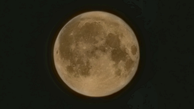
August supermoon, pictured over County Durham.
A supermoon pictured over County Durham, looming larger in the night sky. - © Rachel Easterbrook

The final supermoon of 2025 rises tonight, and it's the third consecutive supermoon since October!

December's Cold Moon is not only the third supermoon in a row, but precedes yet another in January to start 2026.

Conditions for seeing the event are mixed for the UK and Ireland, with the best visibility to be found in Wales, southern England, and parts of Ireland.

Like all full moons, Native Americans provided a name for the December moon, the Cold Moon. Reflecting the time of year when the air cools and winter truly takes hold.

A supermoon occurs when the full moon coincides with the perigee, this is the closest point to Earth in the Moon’s orbit.

Compared to a full moon at its apogee, its furthest point away, a supermoon is typically 30% brighter and 13% larger.

How is visibility near you?WeatherRadar
Ryan Hathaway
More on the topic
Japan braces itself for Typhoon Dolphin. Landslides feared. . . Wednesday, 5 August 2026
Weather map showing a typhoon south of Japan. The centre of the storm is over the Pacific and is moving westwards. The coloured wind fields indicate its high intensity.
Wednesday, 5 August 2026

Landslides feared

Japan braces itself for Typhoon Dolphin
Huge hailstones in Poland. Severe weather hits towns. . . Friday, 7 August 2026
Friday, 7 August 2026

Severe weather hits towns

Huge hailstones in Poland
Getting through the latest heatwave. Tips to beat the heat. . . Tuesday, 11 August 2026
Split graphic showing temperatures up to 35°C in England and 28°C in Ireland beside a person applying sunscreen, with a heat warning symbol highlighting hot weather.
Tuesday, 11 August 2026

Tips to beat the heat

Getting through the latest heatwave
All weather news
This might also interest you
Super Typhoon Bavi threatens Taiwan. Up to 1,000 mm of rain. . . Wednesday, 8 July 2026
The image shows an intense tropical cyclone over the western Pacific, east of Taiwan and the Philippines. The centre of the system is depicted as a light purple and white vortex with a clearly visible eye, surrounded by a ring of red and orange areas indicating the strongest wind speeds. A white arrow marks the typhoon’s predicted track towards the north-west, in the direction of Taiwan. To the west of the storm lie the Philippines, with the cities of Manila and Cebu; to the north of these lies Taiwan, with Taipei. Further west, the Chinese coast, including Hong Kong, and parts of Vietnam can be seen. The coloured wind map shows predominantly green areas outside the storm’s core, indicating significantly weaker winds. White streamlines illustrate the typhoon’s anti-clockwise circulation in the Northern Hemisphere. The highest wind speeds are concentrated around the eye of the cyclone.
Wednesday, 8 July 2026

Up to 1,000 mm of rain

Super Typhoon Bavi threatens Taiwan
Long-term trends need a pinch of salt. 40 °C in July?. . . Tuesday, 30 June 2026
Temperature radar of 2022 heatwave where the all-time temperature record in the UK was set. Warning symbol overlain.
Tuesday, 30 June 2026

40 °C in July?

Long-term trends need a pinch of salt
Turbulent weather in the Canary Islands. Storm and rain. . . Friday, 12 December 2025
Weather graphic showing rain and wind fields over the Canary Islands and a central warning symbol.
Friday, 12 December 2025

Storm and rain

Turbulent weather in the Canary Islands
All articles
Weather & Radar

Weather & Radar is also available on

Google Play StoreApp Store

Company

Contact us Privacy Policy Legal info Accessibility statement

Services

Uploader

Socials

facebooktwittertikToklinkList