Home
Weather London
WeatherRadar
RainfallRadar
TemperatureRadar
WindRadar
LightningRadar
Weather News
Editor's Pick
Discover the app
Weather widget
Contact us
Apps
Career
    Home / Editor's Pick /

    Clearer by Saturday - Warnings with snow to end the week

15:32
11 February 2026

Clearer by Saturday
Warnings with snow to end the week

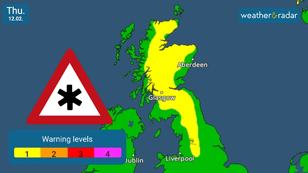
UK warning map dated Thu 12.02 showing snow and ice warning levels with yellow shading across much of Scotland and parts of northern England, green elsewhere, a snowflake warning icon, and a legend indicating levels 1 to 4.
Snow and ice warnings for Thursday.

Warnings are live with a wider return of snowfall setting in from Thursday into Friday morning.

The persistent rain also hangs around as snow forms, meaning settling snow is unlikely outside of higher altitudes where up to 5 cm of snow could fall.

Initially spreading across southern Scotland and northern England, but Friday morning snow moves further south into Wales and central England.

Heavier snowfall amounts of up to 10 cm is possible locally, though the rain and falling temperatures are likely to produce ice too.

After the snow and rain, skies finally clear for Saturday bringing a day of winter's sun as temperatures drop down into freezing.

Ryan Hathaway
More on the topic
Record ocean heat halting hurricanes. Strong El Niño influence. . . Friday, 11 September 2026
A weather map shows a calm Atlantic Ocean with no hurricanes, alongside a picture of the sea.
Friday, 11 September 2026

Strong El Niño influence

Record ocean heat halting hurricanes
Autumn colours light the skies. Your weather - Your shots. . . Sunday, 13 September 2026
Split image showing a fiery red-orange sunset over a rural road and fields beside a golden sea sunset with a silhouetted seabird in flight.
Sunday, 13 September 2026

Your weather - Your shots

Autumn colours light the skies
Cheshire Gap produces shower funnel. Local phenomenon. . . Wednesday, 9 September 2026
Weather map showing showers moving southeast from Liverpool toward Birmingham, driven by Cheshire Gap convergence across central England.
Wednesday, 9 September 2026

Local phenomenon

Cheshire Gap produces shower funnel
All weather news
This might also interest you
New records for England and Wales. Broken again tomorrow?. . . Thursday, 25 June 2026
Temperature map of southwest Britain on 25.06 showing extreme heat across southern Wales and southwest England, with Bute Park in Cardiff highlighted at 34.2°C and Yeovilton at 36.4°C amid widespread deep red heat zones.
Thursday, 25 June 2026

Broken again tomorrow?

New records for England and Wales
Historic Storm Éowyn arrives. On this day.... . . Saturday, 24 January 2026
Split image showing a person in a yellow jacket struggling against strong winds and heavy rain on a street at night on the left, and an Irish wind forecast map on the right with red and purple shading, gusts up to 75 mph, and a wind warning icon, divided by a curved white line.
Saturday, 24 January 2026

On this day...

Historic Storm Éowyn arrives
Long-term trends need a pinch of salt. 40 °C in July?. . . Tuesday, 30 June 2026
Temperature radar of 2022 heatwave where the all-time temperature record in the UK was set. Warning symbol overlain.
Tuesday, 30 June 2026

40 °C in July?

Long-term trends need a pinch of salt
All articles
Weather & Radar

Weather & Radar is also available on

Google Play StoreApp Store

Company

Contact us Privacy Policy Legal info Accessibility statement

Services

Uploader

Socials

facebooktwittertikToklinkList