Home
Weather London
WeatherRadar
RainfallRadar
TemperatureRadar
WindRadar
LightningRadar
Weather News
Editor's Pick
Discover the app
Weather widget
Contact us
Apps
Career
    Home / Editor's Pick /

    Bathed in colour: Aurora shines over the UK and Ireland

14:00
27 February 2023

Bathed in colour
Aurora shines over the UK and Ireland

Aurora borealis
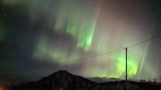
Sunday night's aurora snapped in Talmine, Scotland. - © Dawn Gibson-Hylands

The Northern Lights were spotted across the UK and Ireland on Sunday, and could appear again tonight!

Intense sightings of the aurora borealis were reported across the two countries yesterday thanks to the arrival of a strong solar flare from the Sun.

The natural phenomenon is typically found around the Earth’s poles, however stronger periods of solar activity can result in auroras descending to more southerly latitudes.

Aurora Borealis
Aurora over bridge
Aurora
Aurora
1/4
The display was also captured in Dunkeld, Perthshire last night. - © Keith Morris

In the UK, the aurora can be seen in the far north of Scotland at times of moderate activity in the right conditions.

For the display to be visible as far south as Cornwall is rare and only occurs at times of high solar activity.

In addition to reports in the UK and Ireland, the lights were also spotted in Europe with Weather & Radar users on the continent sending in their views of the lights.

We can expect more auroras in the coming years as the Sun approaches the solar maximum in 2025. This is the point in its 11-year solar cycle at which activity is at its highest.

Further sightings of the Northern Lights are expected tonight however thick cloud cover obscures the night sky for almost all areas of the UK and Ireland.

Check out the WeatherRadar for conditions in your area tonight and to find out exactly how auroras form take a look at our Weather Explained video below.

Aurora events
Ryan Hathaway
More on the topic
A marked change in the weather. Cold front heading south. . . Monday, 7 September 2026
Map of Europe showing a cold front stretching from Scandinavia to Spain. Thunderstorms are shown in southern and central Europe.
Monday, 7 September 2026

Cold front heading south

A marked change in the weather
Warm waters raise severe weather risk. Mediterranean bathtub. . . Friday, 4 September 2026
Left: Map showing water temperatures in the Mediterranean; Right: Dark clouds over a stretch of Mediterranean coastline. A bolt of lightning strikes and a curtain of rain can be seen.
Friday, 4 September 2026

Mediterranean bathtub

Warm waters raise severe weather risk
Extreme weather contrasts in Europe. Heat versus constant rain. . . Thursday, 3 September 2026
On the left, the Temperature Radar shows high temperatures in Spain; on the right, the Weather Radar shows rain in Central Europe
Thursday, 3 September 2026

Heat versus constant rain

Extreme weather contrasts in Europe
All weather news
This might also interest you
Super Typhoon Bavi threatens Taiwan. Up to 1,000 mm of rain. . . Wednesday, 8 July 2026
The image shows an intense tropical cyclone over the western Pacific, east of Taiwan and the Philippines. The centre of the system is depicted as a light purple and white vortex with a clearly visible eye, surrounded by a ring of red and orange areas indicating the strongest wind speeds. A white arrow marks the typhoon’s predicted track towards the north-west, in the direction of Taiwan. To the west of the storm lie the Philippines, with the cities of Manila and Cebu; to the north of these lies Taiwan, with Taipei. Further west, the Chinese coast, including Hong Kong, and parts of Vietnam can be seen. The coloured wind map shows predominantly green areas outside the storm’s core, indicating significantly weaker winds. White streamlines illustrate the typhoon’s anti-clockwise circulation in the Northern Hemisphere. The highest wind speeds are concentrated around the eye of the cyclone.
Wednesday, 8 July 2026

Up to 1,000 mm of rain

Super Typhoon Bavi threatens Taiwan
A frozen start to the weekend. Icy conditions. . . Friday, 13 February 2026
UK temperature map dated 14.02 showing widespread subzero values in blue shading, with readings such as −4 in Glasgow, −3 in Dublin, and −2 in London, alongside a blue thermometer icon.
Friday, 13 February 2026

Icy conditions

A frozen start to the weekend
New records for England and Wales. Broken again tomorrow?. . . Thursday, 25 June 2026
Temperature map of southwest Britain on 25.06 showing extreme heat across southern Wales and southwest England, with Bute Park in Cardiff highlighted at 34.2°C and Yeovilton at 36.4°C amid widespread deep red heat zones.
Thursday, 25 June 2026

Broken again tomorrow?

New records for England and Wales
All articles
Weather & Radar

Weather & Radar is also available on

Google Play StoreApp Store

Company

Contact us Privacy Policy Legal info Accessibility statement

Services

Uploader

Socials

facebooktwittertikToklinkList