Home
Weather London
WeatherRadar
RainfallRadar
TemperatureRadar
WindRadar
LightningRadar
Weather News
Editor's Pick
Discover the app
Weather widget
Contact us
Apps
Career
    Home / Editor's Pick /

    Storm hits the Iberian Peninsula

13:37
11 November 2026

Hurricane-force gusts
Storm hits the Iberian Peninsula

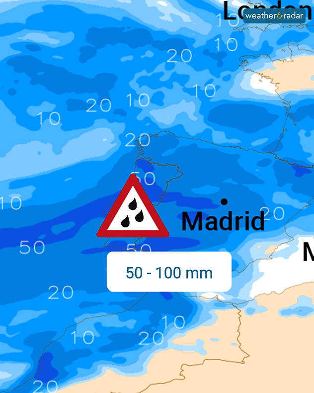
The weather on the Iberian Peninsula is being shaken by a powerful storm system bringing hurricane-force gusts of up to 70 mph to the Portuguese coast.

In some areas, the gusts may be even stronger as locally named Storm Charles moves through Portugal and Spain.

Follow the storm live on the WindRadar

Charles initially affects Portugal, as the day progresses, Spain will also feel the full force of the storm. Conditions will become stormy in the afternoon and evening, particularly in Andalusia. Gale-force winds cannot be ruled out in the mountains there either.

As well as the storm, there will also be a great deal of rain until Thursday.

On top of that, there will be plenty of rain. Widespread rainfall of up to 50 mm is expected by Thursday, with localised amounts of up to 100 mm, bringing a risk of flooding.

Weather & Radar editorial team

More on the topic

Conditions combine to reduce air quality. Light winds and fireworks. . . Tuesday, 10 November 2026
Split image showing a UK wind map with 25 mph near Cardiff and 19 mph near London, beside colourful fireworks above illuminated waterfront buildings.
Tuesday, 10 November 2026

Light winds and fireworks

Conditions combine to reduce air quality
Sunshine returns as gloom lifts. Brighter days ahead. . . Wednesday, 11 November 2026
Weather map showing widespread sunshine across the UK and Ireland, scattered wintry showers over northern Scotland and the North Sea, and temperatures of 6 to 9°C.
Wednesday, 11 November 2026

Brighter days ahead

Sunshine returns as gloom lifts
Foggy mornings and crisp autumn days. Your weather - Your shots. . . Sunday, 8 November 2026
Sunday, 8 November 2026

Your weather - Your shots

Foggy mornings and crisp autumn days
All weather news

This might also interest you

Super Typhoon Bavi threatens Taiwan. Up to 1,000 mm of rain. . . Wednesday, 8 July 2026
The image shows an intense tropical cyclone over the western Pacific, east of Taiwan and the Philippines. The centre of the system is depicted as a light purple and white vortex with a clearly visible eye, surrounded by a ring of red and orange areas indicating the strongest wind speeds. A white arrow marks the typhoon’s predicted track towards the north-west, in the direction of Taiwan. To the west of the storm lie the Philippines, with the cities of Manila and Cebu; to the north of these lies Taiwan, with Taipei. Further west, the Chinese coast, including Hong Kong, and parts of Vietnam can be seen. The coloured wind map shows predominantly green areas outside the storm’s core, indicating significantly weaker winds. White streamlines illustrate the typhoon’s anti-clockwise circulation in the Northern Hemisphere. The highest wind speeds are concentrated around the eye of the cyclone.
Wednesday, 8 July 2026

Up to 1,000 mm of rain

Super Typhoon Bavi threatens Taiwan
Historic Storm Éowyn arrives. On this day.... . . Saturday, 24 January 2026
Split image showing a person in a yellow jacket struggling against strong winds and heavy rain on a street at night on the left, and an Irish wind forecast map on the right with red and purple shading, gusts up to 75 mph, and a wind warning icon, divided by a curved white line.
Saturday, 24 January 2026

On this day...

Historic Storm Éowyn arrives
Long-term trends need a pinch of salt. 40 °C in July?. . . Tuesday, 30 June 2026
Temperature radar of 2022 heatwave where the all-time temperature record in the UK was set. Warning symbol overlain.
Tuesday, 30 June 2026

40 °C in July?

Long-term trends need a pinch of salt
All articles
Weather & Radar

Weather & Radar is also available on

Google Play StoreApp Store

Company

Contact us Privacy Policy Legal info Accessibility statement

Services

Uploader

Socials

facebooktwittertikToklinkList