Home
Weather London
WeatherRadar
RainfallRadar
TemperatureRadar
WindRadar
LightningRadar
Weather News
Editor's Pick
Discover the app
Weather widget
Contact us
Apps
Career
    Home / Editor's Pick /

    Another bout of disruption: Heavy rain again in the south of France

12:00
4 November 2026

Another bout of disruption
Heavy rain again in the south of France

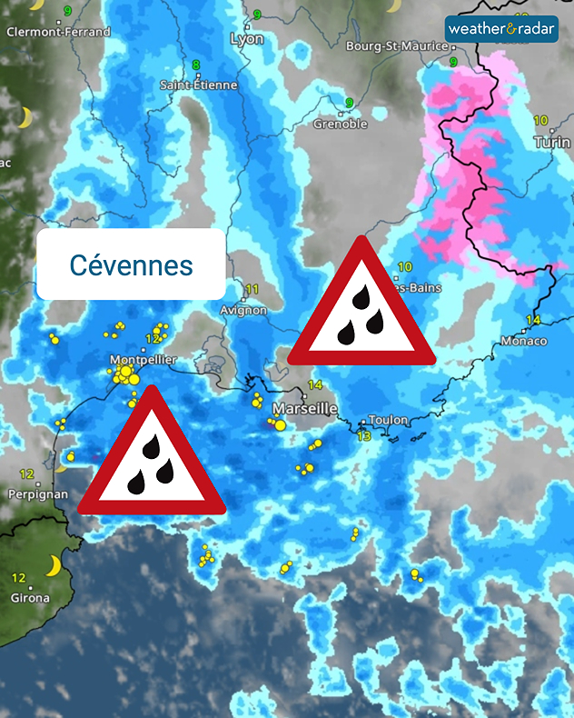
For the fourth time this autumn, heavy rainfall is affecting the south of France. The next spell of bad weather is now set to hit the area between Montpellier, Marseille, and Montélimar.

By Friday, widespread rainfall of between 100 and 200 mm is expected. There is a renewed risk of flooding and flash floods, particularly in areas where large amounts of rain fall in a short space of time.

Follow the situation on WetterRadar

The problem is that the ground is already saturated in many places. In the Hérault department, there have already been several instances this autumn of 250 to 350 mm of rain falling within a few days. Further downpours could therefore quickly lead to problems.

Risk of severe weather: Heavy rain expected over the coming days

It is no coincidence that this region, of all places, is repeatedly affected. In autumn, low-pressure systems often bring moist air from the Mediterranean to the south of France. In the Cévennes mountains, this air is forced to rise, causing the rainfall to intensify.

Weather & Radar editorial team

More on the topic

Brisk easterly winds chill the Channel. Feels like temperature. . . Wednesday, 4 November 2026
Wind map showing 35 mph winds near London, Plymouth and Cherbourg, with a windsock symbol and white arrow pointing west along the English Channel.
Wednesday, 4 November 2026

Feels like temperature

Brisk easterly winds chill the Channel
Wettest week in England for two years. Stormy assistance. . . Thursday, 29 October 2026
Weather map for Saturday 24.10 showing a swirling Atlantic low, Storm Boelo, west of Scotland and widespread blue rain bands across the UK, Ireland and northern France.
Thursday, 29 October 2026

Stormy assistance

Wettest week in England for two years
A final October collection. Your weather - Your shots. . . Sunday, 1 November 2026
Split image showing fog covering seafront gardens and terraced houses beside a bright full moon above orange sunset clouds and silhouetted trees.
Sunday, 1 November 2026

Your weather - Your shots

A final October collection
All weather news

This might also interest you

Storm Chandra makes impact. Severe gales & heavy rain. . . Tuesday, 27 January 2026
Split image showing strong winds over the UK on a forecast map and widespread rain and snow on a weather radar map.
Tuesday, 27 January 2026

Severe gales & heavy rain

Storm Chandra makes impact
A frozen start to the weekend. Icy conditions. . . Friday, 13 February 2026
UK temperature map dated 14.02 showing widespread subzero values in blue shading, with readings such as −4 in Glasgow, −3 in Dublin, and −2 in London, alongside a blue thermometer icon.
Friday, 13 February 2026

Icy conditions

A frozen start to the weekend
A stormy week in the skies above. Your weather - Your shots. . . Sunday, 30 August 2026
Split image showing lightning branching beneath dark storm clouds above rooftops on the left and an orange-pink sunset over a calm sea on the right.
Sunday, 30 August 2026

Your weather - Your shots

A stormy week in the skies above
All articles
Weather & Radar

Weather & Radar is also available on

Google Play StoreApp Store

Company

Contact us Privacy Policy Legal info Accessibility statement

Services

Uploader

Socials

facebooktwittertikToklinkList