Home
Weather London
WeatherRadar
RainfallRadar
TemperatureRadar
WindRadar
LightningRadar
Weather News
Editor's Pick
Discover the app
Weather widget
Contact us
Apps
Career
    Home / Editor's Pick /

    After heavy rainfall - landslide threatens town in Sicily

09:00
28 January 2026

After heavy rainfall
Landslide threatens town in Sicily

Heavy rainfall has caused a massive landslide in Sicily. The ground in the town of Niscemi in the south of the island has been receding since the weekend.

Residential buildings are now standing directly on the edge of the precipice. As a result, more than 1,500 people have had to leave their homes.

The situation in Niscemi remains critical: the landslide is still active and moving through a residential area.

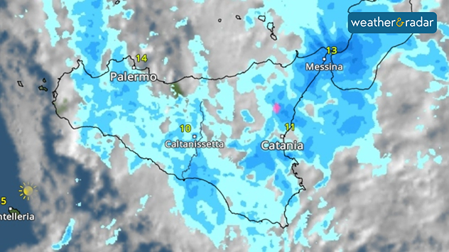
WeatherRadar: Heavy rainfall is moving across Sicily.

Parts of the ground consisting of mud and debris continue to slide downhill, and a front several kilometres long is threatening to give way. Some houses are no longer considered habitable.

The cause was persistent, heavy rainfall that hit the Mediterranean island in recent days. The damage is estimated at around €1.5 billion.

There is no sign of the situation easing in the coming days. Further heavy rainfall and thunderstorms are expected to sweep across the island, particularly during the night from Wednesday to Thursday and continuing into the weekend.

Dennis Oswald
with material from dpa

More on the topic

Preparing for the storms. What to do now. . . Thursday, 22 October 2026
Split image showing Storm Austen winds up to 65 mph near Brest and 55 mph near Plymouth, alongside fallen tree branches on a cordoned-off park path.
Thursday, 22 October 2026

What to do now

Preparing for the storms
Overnight impacts as Austen hits. Power cuts, travel issues. . . Friday, 23 October 2026
Split image showing floodwater surging beneath a railway bridge at night and a wind map with low pressure over the English Channel and 60 mph near Brest.
Friday, 23 October 2026

Power cuts, travel issues

Overnight impacts as Austen hits
Storm Austen approaches. What to expect tonight. . . Thursday, 22 October 2026
Split image showing a wind map with 65 mph near Brest and a swirling storm south of England, beside a man wearing glasses and holding a microphone.
Thursday, 22 October 2026

What to expect tonight

Storm Austen approaches
All weather news

This might also interest you

A stormy week in the skies above. Your weather - Your shots. . . Sunday, 30 August 2026
Split image showing lightning branching beneath dark storm clouds above rooftops on the left and an orange-pink sunset over a calm sea on the right.
Sunday, 30 August 2026

Your weather - Your shots

A stormy week in the skies above
Seasonal warmth between spring thunder. Your weather - Your shots. . . Sunday, 19 April 2026
Split image showing coastal sunset with layered lenticular clouds over rooftops and palm trees on the left, and a green valley with river and hills under soft daylight on the right.
Sunday, 19 April 2026

Your weather - Your shots

Seasonal warmth between spring thunder
New records for England and Wales. Broken again tomorrow?. . . Thursday, 25 June 2026
Temperature map of southwest Britain on 25.06 showing extreme heat across southern Wales and southwest England, with Bute Park in Cardiff highlighted at 34.2°C and Yeovilton at 36.4°C amid widespread deep red heat zones.
Thursday, 25 June 2026

Broken again tomorrow?

New records for England and Wales
All articles
Weather & Radar

Weather & Radar is also available on

Google Play StoreApp Store

Company

Contact us Privacy Policy Legal info Accessibility statement

Services

Uploader

Socials

facebooktwittertikToklinkList