Home
Weather London
WeatherRadar
RainfallRadar
TemperatureRadar
WindRadar
LightningRadar
Weather News
Editor's Pick
Discover the app
Weather widget
Contact us
Apps
Career
    Home / Editor's Pick /

    A heatwave is on the way in Europe – is El Niño to blame?

07:13
16 June 2026

Is El Niño to blame?
A heatwave is on the way in Europe

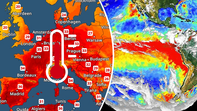
Split image showing a Europe temperature map with widespread red heatwave conditions and temperatures above 30 C on the left, and an El Niño ocean temperature anomaly map of the Pacific Ocean on the right with a broad band of unusually warm water along the equator.
Will El Niño impact temperatures here? - © picture alliance

A heatwave is building once again across Europe. At the same time, the El Niño weather phenonmenon has formed over the eastern Pacific. Is there a link?

Despite some reports, the answer to this question is a resounding no. Although the onset of the El Niño phenomenon has now been officially confirmed, its effects are essentially limited to regions in and around the Pacific Ocean.

Did you know?

The El Niño weather phenomenon recurs every two to seven years with varying intensities. Initial calculations suggest that the El Niño event currently getting underway is likely to be particularly strong. 

This is particularly noticeable in South America and South-East Asia. As a result, increased flooding, heatwaves and droughts are expected there in the coming months. But in California and parts of Mexico, too, the weather could literally go haywire due to El Niño.

In contrast, the heatwave currently sweeping across south-western Europe has nothing to do with El Niño. Rather, a summer "heat dome" has formed over Spain, which is now slowly spreading towards Central Europe.

In fact, the heat in Spain and France is likely to intensify even further as the weekend approaches: maximum temperatures of around 40 °C, or even higher, are expected there.

Learn more about El Niño and the El Niño Southern Oscillation.

Weather & Radar editorial team
More on the topic
Heat becoming a bigger factor in drought. New study. . . Thursday, 23 July 2026
A hand holds dry, dusty earth above a parched field. The ground is cracked and covered with plant debris – a sign of prolonged drought.
Thursday, 23 July 2026

New study

Heat becoming a bigger factor in drought
Typhoon warning for China. Up to 500 mm of rain. . . Friday, 24 July 2026
Weather map of the southern Chinese coast and Taiwan showing a powerful tropical cyclone. The eye of the storm is located near the coastal city of Shantou in the Chinese province of Guangdong. Around the centre, intense shades of red, pink and violet indicate gale-force winds, whilst a large orange wind field extends as far as the west coast of Taiwan. An overlaid windsack warning sign indicates dangerous storm winds. Cities such as Hong Kong, Guangzhou, Xiamen, Taipei and Taichung are shown, as are wind speeds and white flow lines illustrating the cyclonic air circulation.
Friday, 24 July 2026

Up to 500 mm of rain

Typhoon warning for China
Clouds return to capture the scene. Your weather - Your shots. . . Sunday, 26 July 2026
Waxing crescent Moon above vivid pink and magenta sunset clouds, with silhouetted trees along the horizon beneath a deepening blue twilight sky.
Sunday, 26 July 2026

Your weather - Your shots

Clouds return to capture the scene
All weather news
This might also interest you
Flooding, gales, and heavy snow. Storm Chandra. . . Tuesday, 27 January 2026
Split image showing aerial flooding in a town with muddy water covering roads on the left, and a rural road on the right blocked by heavy snowfall with vans stopped and a person walking in snow.
Tuesday, 27 January 2026

Storm Chandra

Flooding, gales, and heavy snow
Turbulent weather in the Canary Islands. Storm and rain. . . Friday, 12 December 2025
Weather graphic showing rain and wind fields over the Canary Islands and a central warning symbol.
Friday, 12 December 2025

Storm and rain

Turbulent weather in the Canary Islands
A frozen start to the weekend. Icy conditions. . . Friday, 13 February 2026
UK temperature map dated 14.02 showing widespread subzero values in blue shading, with readings such as −4 in Glasgow, −3 in Dublin, and −2 in London, alongside a blue thermometer icon.
Friday, 13 February 2026

Icy conditions

A frozen start to the weekend
All articles
Weather & Radar

Weather & Radar is also available on

Google Play StoreApp Store

Company

Contact us Privacy Policy Legal info Accessibility statement

Services

Uploader

Socials

facebooktwittertikToklinkList