Home
Weather London
WeatherRadar
RainfallRadar
TemperatureRadar
WindRadar
LightningRadar
Weather News
Editor's Pick
Discover the app
Weather widget
Contact us
Apps
Career
    Home / Editor's Pick /

    Gales and rain - Severe weather brings disruption

08:51
14 October 2026

Gales and rain
Severe weather brings disruption

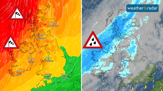
Split weather map showing winds up to 45 mph near Aberdeen and Cork, alongside heavy rain across Scotland and western Ireland with warning symbols.
Wind and rain warnings cover western areas on Wednesday.

Travel routes are seeing early disruption as strong winds build, with parts of Ireland and Scotland still under warnings.

Gusting winds reaching up to 55 mph already reached western Scotland Wednesday morning. Resulting in the cancellation of 13 ferry routes in the west of Scotland, including links between the Outer Hebrides and the mainland.

Meanwhile, ScotRail is also reporting some disruption with speed restrictions on some lines, including the Fort William - Mallaig line due to rain while all flights at Barra and Benbecula airports are cancelled.

Otherwise, road travel could face delays due to debris in the road while vans and lorries should take care on roads exposed to gusts.

Along western coasts of Scotland and Ireland the severe winds are likely to result in larger coastal waves and possible overlapping.

Be sure to keep an eye on the responsible system today via the WindRadar.

Ryan Hathaway
More on the topic
Warnings for a windswept Wednesday. Coastal gales. . . Tuesday, 13 October 2026
Wind map showing 45 mph near Aberdeen, 40 mph near Glasgow and Cork, and red strong wind warning symbols across western Scotland and Ireland.
Tuesday, 13 October 2026

Coastal gales

Warnings for a windswept Wednesday
Autumn weather starting to appear. Your weather - Your shots. . . Sunday, 11 October 2026
Split image showing golden sun rays shining through a tree in a misty field and a circular fallstreak hole in a blue sky with textured clouds.
Sunday, 11 October 2026

Your weather - Your shots

Autumn weather starting to appear
Former hurricane to record storm. Isaias affecting Europe. . . Wednesday, 14 October 2026
WindRadar shows a powerful storm system south-west of Iceland. Red and purple colours indicate extreme wind speeds. Arrows show the direction of rotation, whilst a windsock symbol warns of a storm.
Wednesday, 14 October 2026

Isaias affecting Europe

Former hurricane to record storm
All weather news
This might also interest you
Storm Chandra makes impact. Severe gales & heavy rain. . . Tuesday, 27 January 2026
Split image showing strong winds over the UK on a forecast map and widespread rain and snow on a weather radar map.
Tuesday, 27 January 2026

Severe gales & heavy rain

Storm Chandra makes impact
Flooding, gales, and heavy snow. Storm Chandra. . . Tuesday, 27 January 2026
Split image showing aerial flooding in a town with muddy water covering roads on the left, and a rural road on the right blocked by heavy snowfall with vans stopped and a person walking in snow.
Tuesday, 27 January 2026

Storm Chandra

Flooding, gales, and heavy snow
Long-term trends need a pinch of salt. 40 °C in July?. . . Tuesday, 30 June 2026
Temperature radar of 2022 heatwave where the all-time temperature record in the UK was set. Warning symbol overlain.
Tuesday, 30 June 2026

40 °C in July?

Long-term trends need a pinch of salt
All articles
Weather & Radar

Weather & Radar is also available on

Google Play StoreApp Store

Company

Contact us Privacy Policy Legal info Accessibility statement

Services

Uploader

Socials

facebooktwittertikToklinkList