Home
Weather London
WeatherRadar
RainfallRadar
TemperatureRadar
WindRadar
LightningRadar
Weather News
Editor's Pick
Discover the app
Weather widget
Contact us
Apps
Career
    Home / Editor's Pick /

    Hail and storm damage - Violent storms impacting northern Italy

12:00
16 July 2026

Hail and storm damage
Violent storms impacting northern Italy

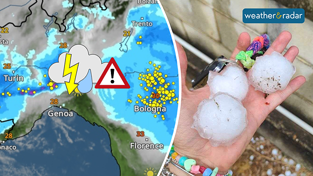
Severe thunderstorms swept through northern Italy on Wednesday afternoon. So-called supercells moved from Piedmont through Emilia-Romagna to Friuli-Venezia Giulia.

Did you know?

Supercells are among the most dangerous thunderstorms. They often bring large hailstones, torrential rain, and severe gusts of wind. The risk of tornadoes is also higher than with other types of thunderstorm.

In Piedmont, hailstones the size of golf balls fell in some places; near Turin, hail measuring up to 9 centimetres were reported. Around Bologna, gale-force winds of around 75 mph uprooted trees and damaged roofs, causing widespread disruption on the roads.

The WeatherRadar shows yesterday’s storms, which brought large to very large hailstones in some areas.

There is a risk of further severe localised thunderstorms in Italy today and tomorrow, particularly near the borders with France, Switzerland, and Austria. Keep an eye on the situation with the WeatherRadar.

Track thunderstorms liveGlobal WeatherRadar

Weather & Radar editorial team
More on the topic
Severe weather spreads across Europe. Lightning, hail, gales. . . Wednesday, 15 July 2026
Split image showing a dramatic supercell thunderstorm with dark rotating clouds over open countryside on the left, and a severe thunderstorm warning map on the right highlightning elevated storm risk across parts of central Europe, including northern Italy, Switzerland, eastern France, and southern Germany.
Wednesday, 15 July 2026

Lightning, hail, gales

Severe weather spreads across Europe
Heatwave keeps a firm grip on Europe. Around 40°C in places. . . Monday, 13 July 2026
A collage featuring a temperature radar map of Europe and a fire-fighting aircraft in action over a forest fire. In the centre, a heat symbol warns of persistently high temperatures.
Monday, 13 July 2026

Around 40°C in places

Heatwave keeps a firm grip on Europe
Heat warnings cover much of Ireland. Until the weekend. . . Thursday, 16 July 2026
Temperature map of Ireland showing warm to hot conditions nationwide, with temperatures ranging from 27°C in Galway to 23°C in Dublin. A heat warning symbol to the west indicates elevated temperatures.
Thursday, 16 July 2026

Until the weekend

Heat warnings cover much of Ireland
All weather news
This might also interest you
Historic Storm Éowyn arrives. On this day.... . . Saturday, 24 January 2026
Split image showing a person in a yellow jacket struggling against strong winds and heavy rain on a street at night on the left, and an Irish wind forecast map on the right with red and purple shading, gusts up to 75 mph, and a wind warning icon, divided by a curved white line.
Saturday, 24 January 2026

On this day...

Historic Storm Éowyn arrives
Super Typhoon Bavi threatens Taiwan. Up to 1,000 mm of rain. . . Wednesday, 8 July 2026
The image shows an intense tropical cyclone over the western Pacific, east of Taiwan and the Philippines. The centre of the system is depicted as a light purple and white vortex with a clearly visible eye, surrounded by a ring of red and orange areas indicating the strongest wind speeds. A white arrow marks the typhoon’s predicted track towards the north-west, in the direction of Taiwan. To the west of the storm lie the Philippines, with the cities of Manila and Cebu; to the north of these lies Taiwan, with Taipei. Further west, the Chinese coast, including Hong Kong, and parts of Vietnam can be seen. The coloured wind map shows predominantly green areas outside the storm’s core, indicating significantly weaker winds. White streamlines illustrate the typhoon’s anti-clockwise circulation in the Northern Hemisphere. The highest wind speeds are concentrated around the eye of the cyclone.
Wednesday, 8 July 2026

Up to 1,000 mm of rain

Super Typhoon Bavi threatens Taiwan
Storm Chandra makes impact. Severe gales & heavy rain. . . Tuesday, 27 January 2026
Split image showing strong winds over the UK on a forecast map and widespread rain and snow on a weather radar map.
Tuesday, 27 January 2026

Severe gales & heavy rain

Storm Chandra makes impact
All articles
Weather & Radar

Weather & Radar is also available on

Google Play StoreApp Store

Company

Contact us Privacy Policy Legal info Accessibility statement

Services

Uploader

Socials

facebooktwittertikToklinkList