Home
Weather London
WeatherRadar
RainfallRadar
TemperatureRadar
WindRadar
LightningRadar
Weather News
Editor's Pick
Discover the app
Weather widget
Contact us
Apps
Career
    Home / Editor's Pick /

    Heatwave keeps a firm grip on Europe - around 40°C in places

10:36
13 July 2026

Around 40°C in places
Heatwave keeps a firm grip on Europe

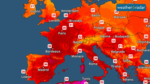
The latest heatwave shows no sign of abating in parts of Europe as hot air from Africa pushes temperatures above 30°C for many.

In Spain, parts of France, and Sardinia, temperatures could even reach 40°C in some areas. For many countries, this is already the third heatwave of the year.

Did you know?

A new temperature record of 40.9 degrees was recorded in Barcelona last Wednesday.

Ongoing drought is making the situation worse as forest fires rapidly spread in several countries. In France, the Fontainebleau forest, south of Paris, is ablaze across hundreds of hectares; with fire-fighting aircraft being deployed.

Meanwhile, a major incident was declared in North Wales due to an ongoing fire on Conwy Mountain. As of Monday, 19 fires were being tackled across England and Wales with growing winds worsening the situation.

TemperatureRadar: Temperatures will rise above 30°C across a wide area, with local highs of up to 40°C.

For the first time ever, a stage of the Tour de France has been shortened as the effects of the heat continue. Several nuclear reactors have also had to be scaled back or temporarily shut down in France too.

There is no sign of the situation easing for the time being as the heatwave is continues in many places. At the same time, drought conditions and the risk of forest fires remain high in many regions.

Thunderstorms only help local areasWeatherRadar Europe
Tommy Kühnlein
More on the topic
Very high UV levels during the heatwave. Sun cream at the ready!. . . Wednesday, 8 July 2026
Split graphic showing a UK temperature map with hot conditions across England and Wales, temperatures reaching 32 °C near London, and a UV warning icon on the left, alongside a person applying sunscreen in bright sunshine on the right.
Wednesday, 8 July 2026

Sun cream at the ready!

Very high UV levels during the heatwave
Heatwave versus storm system. Contrasts in Europe. . . Tuesday, 7 July 2026
A temperature map of Europe showing a major heatwave in the south-west and significantly cooler air in the north. Two thermometer symbols illustrate the stark contrast in temperature.
Tuesday, 7 July 2026

Contrasts in Europe

Heatwave versus storm system
Seeking the cooler scenes. Your weather - Your shots. . . Sunday, 12 July 2026
Split image showing a cat silhouetted on a fence at golden hour with the low sun behind it on the left, and a calm marina with boats, reflective water, and thin high clouds under bright sunshine on the right.
Sunday, 12 July 2026

Your weather - Your shots

Seeking the cooler scenes
All weather news
This might also interest you
Super Typhoon Bavi threatens Taiwan. Up to 1,000 mm of rain. . . Wednesday, 8 July 2026
The image shows an intense tropical cyclone over the western Pacific, east of Taiwan and the Philippines. The centre of the system is depicted as a light purple and white vortex with a clearly visible eye, surrounded by a ring of red and orange areas indicating the strongest wind speeds. A white arrow marks the typhoon’s predicted track towards the north-west, in the direction of Taiwan. To the west of the storm lie the Philippines, with the cities of Manila and Cebu; to the north of these lies Taiwan, with Taipei. Further west, the Chinese coast, including Hong Kong, and parts of Vietnam can be seen. The coloured wind map shows predominantly green areas outside the storm’s core, indicating significantly weaker winds. White streamlines illustrate the typhoon’s anti-clockwise circulation in the Northern Hemisphere. The highest wind speeds are concentrated around the eye of the cyclone.
Wednesday, 8 July 2026

Up to 1,000 mm of rain

Super Typhoon Bavi threatens Taiwan
Historic Storm Éowyn arrives. On this day.... . . Saturday, 24 January 2026
Split image showing a person in a yellow jacket struggling against strong winds and heavy rain on a street at night on the left, and an Irish wind forecast map on the right with red and purple shading, gusts up to 75 mph, and a wind warning icon, divided by a curved white line.
Saturday, 24 January 2026

On this day...

Historic Storm Éowyn arrives
Flooding, gales, and heavy snow. Storm Chandra. . . Tuesday, 27 January 2026
Split image showing aerial flooding in a town with muddy water covering roads on the left, and a rural road on the right blocked by heavy snowfall with vans stopped and a person walking in snow.
Tuesday, 27 January 2026

Storm Chandra

Flooding, gales, and heavy snow
All articles
Weather & Radar

Weather & Radar is also available on

Google Play StoreApp Store

Company

Contact us Privacy Policy Legal info Accessibility statement

Services

Uploader

Socials

facebooktwittertikToklinkList