Home
Weather London
WeatherRadar
RainfallRadar
TemperatureRadar
WindRadar
LightningRadar
Weather News
Editor's Pick
Discover the app
Weather widget
Contact us
Apps
Career
    Home / Editor's Pick /

    33.5 °C and still rising - Hottest May day on record

12:29
25 May 2026

33.5 °C and still rising
Hottest May day on record

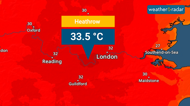
Heat map centered on London showing intense red temperatures across southeast England, with Heathrow highlighted at 33.5°C and nearby cities around 30–32°C.
A new record temperature for the month of May.

It's officially the hottest May day in recorded history after a reading of 33.5 °C in London on Monday.

This high was recorded just after midday, before temperatures reach their peak meaning the final record-high will inch even higher. This passes the existing high of 32.8 °C.

Not only is it the hottest day in May, it's also a new record for any bank holiday Monday, besting the high of 33.3 °C on the August bank holiday in 2019.

Across the UK, heatwave thresholds have been met. Despite the heat there, in Ireland highs are still lower with a high of around 27 °C in Limerick on Monday.

Temperatures must surpass 25 °C for five consecutive days on the Emerald Isle for a heatwave to be declared which is not going to happen. The warmth breaks there on Thursday.

To make the sticky conditions worse, there are water shortages in some areas. In Kent, bottled water stations have been set up with around 500 properties with no water supply.

Daily highs of around 33 °C are expected on the bank holiday Monday with many people out in the strong sunshine. Keep hydrated and apply plenty of sunscreen!

Staying sun safe in the heatwaveread more
Ryan Hathaway
More on the topic
Warm waters raise severe weather risk. Mediterranean bathtub. . . Friday, 4 September 2026
Left: Map showing water temperatures in the Mediterranean; Right: Dark clouds over a stretch of Mediterranean coastline. A bolt of lightning strikes and a curtain of rain can be seen.
Friday, 4 September 2026

Mediterranean bathtub

Warm waters raise severe weather risk
Severe weather in southern Europe. Thunderstorms & heavy rain. . . Wednesday, 9 September 2026
On the left, dark storm clouds over a coastline. On the right, a weather map shows thunderstorms over the western Mediterranean, with warning symbols for tornadoes, storms and hail.
Wednesday, 9 September 2026

Thunderstorms & heavy rain

Severe weather in southern Europe
A generally gusty Thursday. Moderate but notable wind. . . Wednesday, 2 September 2026
Wind forecast showing widespread 25-30 mph winds across the UK and Ireland, including Glasgow, Dublin, Cork, Cardiff, and London, with a windsock symbol.
Wednesday, 2 September 2026

Moderate but notable wind

A generally gusty Thursday
All weather news
This might also interest you
Bright and warm conditions take hold. Spring-like outlook. . . Thursday, 23 April 2026
Split UK map showing warm temperatures up to 21 degrees in orange on the left and clear sunny conditions with temperatures from 12 to 18 degrees on the right, with sun icons across the country.
Thursday, 23 April 2026

Spring-like outlook

Bright and warm conditions take hold
Storm Chandra makes impact. Severe gales & heavy rain. . . Tuesday, 27 January 2026
Split image showing strong winds over the UK on a forecast map and widespread rain and snow on a weather radar map.
Tuesday, 27 January 2026

Severe gales & heavy rain

Storm Chandra makes impact
A stormy week in the skies above. Your weather - Your shots. . . Sunday, 30 August 2026
Split image showing lightning branching beneath dark storm clouds above rooftops on the left and an orange-pink sunset over a calm sea on the right.
Sunday, 30 August 2026

Your weather - Your shots

A stormy week in the skies above
All articles
Weather & Radar

Weather & Radar is also available on

Google Play StoreApp Store

Company

Contact us Privacy Policy Legal info Accessibility statement

Services

Uploader

Socials

facebooktwittertikToklinkList