Home
Weather London
WeatherRadar
RainfallRadar
TemperatureRadar
WindRadar
LightningRadar
Weather News
Editor's Pick
Discover the app
Weather widget
Contact us
Apps
Career
    Home / Editor's Pick /

    32.6°C in Surrey: Hottest day of the year

15:49
7 September 2023

32.6°C in Surrey
Hottest day of the year

TemperatureRadar
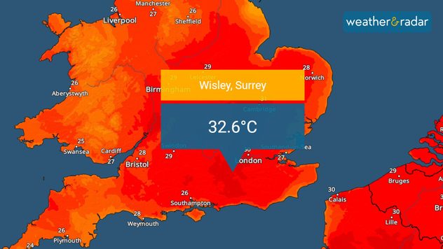
Temperatures reached 32.6°C in Surrey this afternoon, setting a new record.

The UK has recorded its hottest day of 2023 after temperatures surpassed the existing record of 32.2°C this June.

A high of 32.6°C in Wisley, Surrey has officially marked September 7 as the hottest day of the year to date. It comes amid an ongoing heatwave affecting the UK and Ireland.

Previously, a high of 32.2°C recorded twice in June had been the hottest temperature of the year.

Despite the high, it could be short-lived. Temperatures are continuing to build and are expected to peak on Saturday where local highs of 33°C could manifest.

Earlier this week the UK Health Security Agency issued heat-health amber alerts covering the entirety of the UK due to the conditions.

In addition to the record high, today also saw a new record of consecutive September days reaching 30°C in general.

With four days in a row, the previous record of three was bested on Thursday. Three consecutive days of 30°C temperatures had previously been recorded in 1898, 1906, 1911, 2016.

While temperatures dip slightly Friday, it remains warm into Saturday due to the ongoing heatwave, in part caused by an Omega blocking pattern in Europe.

Omega blocking pattern over Europeread more

To cap off a record-breaking month, the current record of 30°C days for September stands at five... it is very possible this too will be broken soon.

Keep track of everything that's happening on the TemperatureRadar.

Ryan Hathaway
More on the topic
How El Niño impacts us worldwide. What actually is it?. . . Tuesday, 15 September 2026
teaser
Tuesday, 15 September 2026

What actually is it?

How El Niño impacts us worldwide
Huge low-pressure system off Iceland. Impacting the UK & Ireland. . . Wednesday, 16 September 2026
WeatherRadar showing a large low-pressure system over the North Atlantic between Greenland and Iceland.
Wednesday, 16 September 2026

Impacting the UK & Ireland

Huge low-pressure system off Iceland
A snowy winter in the Andes. Avalanches and storms. . . Tuesday, 15 September 2026
Tuesday, 15 September 2026

Avalanches and storms

A snowy winter in the Andes
All weather news
This might also interest you
Super Typhoon Bavi threatens Taiwan. Up to 1,000 mm of rain. . . Wednesday, 8 July 2026
The image shows an intense tropical cyclone over the western Pacific, east of Taiwan and the Philippines. The centre of the system is depicted as a light purple and white vortex with a clearly visible eye, surrounded by a ring of red and orange areas indicating the strongest wind speeds. A white arrow marks the typhoon’s predicted track towards the north-west, in the direction of Taiwan. To the west of the storm lie the Philippines, with the cities of Manila and Cebu; to the north of these lies Taiwan, with Taipei. Further west, the Chinese coast, including Hong Kong, and parts of Vietnam can be seen. The coloured wind map shows predominantly green areas outside the storm’s core, indicating significantly weaker winds. White streamlines illustrate the typhoon’s anti-clockwise circulation in the Northern Hemisphere. The highest wind speeds are concentrated around the eye of the cyclone.
Wednesday, 8 July 2026

Up to 1,000 mm of rain

Super Typhoon Bavi threatens Taiwan
New records for England and Wales. Broken again tomorrow?. . . Thursday, 25 June 2026
Temperature map of southwest Britain on 25.06 showing extreme heat across southern Wales and southwest England, with Bute Park in Cardiff highlighted at 34.2°C and Yeovilton at 36.4°C amid widespread deep red heat zones.
Thursday, 25 June 2026

Broken again tomorrow?

New records for England and Wales
Historic Storm Éowyn arrives. On this day.... . . Saturday, 24 January 2026
Split image showing a person in a yellow jacket struggling against strong winds and heavy rain on a street at night on the left, and an Irish wind forecast map on the right with red and purple shading, gusts up to 75 mph, and a wind warning icon, divided by a curved white line.
Saturday, 24 January 2026

On this day...

Historic Storm Éowyn arrives
All articles
Weather & Radar

Weather & Radar is also available on

Google Play StoreApp Store

Company

Contact us Privacy Policy Legal info Accessibility statement

Services

Uploader

Socials

facebooktwittertikToklinkList