Home
Weather London
WeatherRadar
RainfallRadar
TemperatureRadar
WindRadar
LightningRadar
Weather News
Editor's Pick
Discover the app
Weather widget
Contact us
Apps
Career
    Home / Editor's Pick /

    Frontal influence - Rain and blustery winds spread

07:26
2 September 2026

Frontal influence
Rain and blustery winds spread

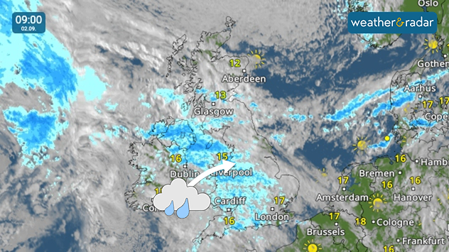
Weather map at 09:00 on 09.09 showing widespread rain across Ireland, Wales, and England, with temperatures of 12 to 17°C.
A front is clear to see as the band of rain moves through the UK.

A fresh Atlantic frontal system moves through the UK and Ireland on Wednesday bringing extensive cloud cover and rain in parts.

After first passing through Ireland in the early morning, the band of rain sat over Northern Ireland, Wales, and western England for the main commuting hours.

From there, it continues pushing east, across England and also dousing parts of southern Scotland later in the day.

It isn't just the rain and cloud to take note of, it's increasingly breezy across Ireland and parts of Wales and southern England later in the day too. Gusts of up to 35 mph over higher ground, and more widely 30 mph.

Temperature for the day sit around the 20°C mark for most, but cooler along the north of Scotland where the daily high sits at 13°C around Thurso.

Keep an eye on the rain and cloud movement on the WeatherRadar as it shifts.

1 day ago
Ryan Hathaway
More on the topic
Summer of 2026: hottest on record. Breaking 2025 record. . . Tuesday, 1 September 2026
Aerial view of a large park with dry yellow-brown grass, intersecting footpaths, and a few people walking across the parched landscape beneath clear summer skies.
Tuesday, 1 September 2026

Breaking 2025 record

Summer of 2026: hottest on record
Severe weather damage in France. Tornado impacts. . . Tuesday, 25 August 2026
On the left, the weather radar shows numerous flashes of lightning over the south of France. On the right, severe tornado damage can be seen in Pomas, with damaged roofs, trees and vehicles.
Tuesday, 25 August 2026

Tornado impacts

Severe weather damage in France
Slow moving rain brings flooding. More alerts live. . . Thursday, 27 August 2026
Weather radar at 11:00 on 27.08 showing widespread heavy rain from Liverpool through the Midlands to eastern England, with an arrow indicating rain moving north.
Thursday, 27 August 2026

More alerts live

Slow moving rain brings flooding
All weather news
This might also interest you
Seasonal warmth between spring thunder. Your weather - Your shots. . . Sunday, 19 April 2026
Split image showing coastal sunset with layered lenticular clouds over rooftops and palm trees on the left, and a green valley with river and hills under soft daylight on the right.
Sunday, 19 April 2026

Your weather - Your shots

Seasonal warmth between spring thunder
Historic Storm Éowyn arrives. On this day.... . . Saturday, 24 January 2026
Split image showing a person in a yellow jacket struggling against strong winds and heavy rain on a street at night on the left, and an Irish wind forecast map on the right with red and purple shading, gusts up to 75 mph, and a wind warning icon, divided by a curved white line.
Saturday, 24 January 2026

On this day...

Historic Storm Éowyn arrives
Storm Chandra makes impact. Severe gales & heavy rain. . . Tuesday, 27 January 2026
Split image showing strong winds over the UK on a forecast map and widespread rain and snow on a weather radar map.
Tuesday, 27 January 2026

Severe gales & heavy rain

Storm Chandra makes impact
All articles
Weather & Radar

Weather & Radar is also available on

Google Play StoreApp Store

Company

Contact us Privacy Policy Legal info Accessibility statement

Services

Uploader

Socials

facebooktwittertikToklinkList