Home
Weather London
WeatherRadar
RainfallRadar
TemperatureRadar
WindRadar
LightningRadar
Weather News
Editor's Pick
Discover the app
Weather widget
Contact us
Apps
Career
    Home / Editor's Pick /

    Your weather - Your shots: Stormy views after a short week

15:00
7 April 2024

Your weather - Your shots
Stormy views after a short week

Mammatus clouds
Rainbow against stormy skies
Pink sky at sunrise
Flat rainbow
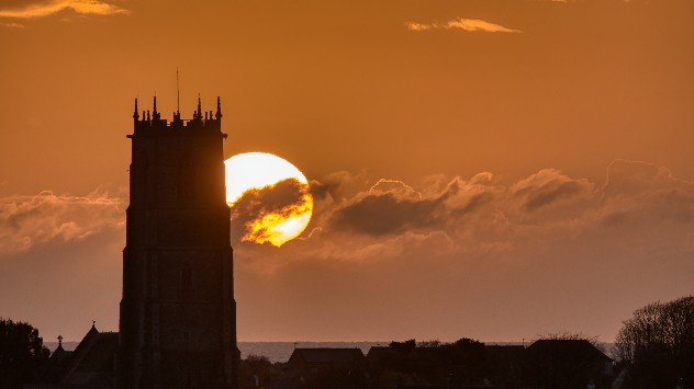
Sunset behind church
1/5
These mammatus clouds, hanging like pouches in the sky, were seen in Mapledurham, Oxfordshire. - © Weather & Radar Uploader

Another week ends with the arrival of a storm system, but before Kathleen's arrival, there were plenty of opportunities to get out and snap some weather shots.

The extended weekend for many over Easter saw the arrival of rainbows as well as rainfall. Not that we are complaining!

If you captured any shots of the recent storms, we would love to see them. Simply tap the image icon in the app, or use our dedicated uploaders for the UK and Ireland to submit.

Get involved: How to use the uploaderread more
Weather & Radar editorial team
More on the topic
Severe weather rolls on in Europe. Heavy rain and hail. . . Thursday, 17 September 2026
Weather radar showing severe thunderstorms and frequent lightning over northern Italy.
Thursday, 17 September 2026

Heavy rain and hail

Severe weather rolls on in Europe
Low delivers days of gusty conditions. Into the weekend. . . Thursday, 17 September 2026
Wind map showing low pressure near the Faroe Islands, with winds reaching 35 mph around Aberdeen and Dublin and stronger Atlantic winds west of the UK.
Thursday, 17 September 2026

Into the weekend

Low delivers days of gusty conditions
Colourful skies and scenic clouds cover. Your weather - Your shots. . . Sunday, 20 September 2026
Split image showing a golden sunset over the sea beneath layered clouds and a pink-purple sunset reflected across calm riverside water.
Sunday, 20 September 2026

Your weather - Your shots

Colourful skies and scenic clouds cover
All weather news
This might also interest you
Flooding, gales, and heavy snow. Storm Chandra. . . Tuesday, 27 January 2026
Split image showing aerial flooding in a town with muddy water covering roads on the left, and a rural road on the right blocked by heavy snowfall with vans stopped and a person walking in snow.
Tuesday, 27 January 2026

Storm Chandra

Flooding, gales, and heavy snow
Super Typhoon Bavi threatens Taiwan. Up to 1,000 mm of rain. . . Wednesday, 8 July 2026
The image shows an intense tropical cyclone over the western Pacific, east of Taiwan and the Philippines. The centre of the system is depicted as a light purple and white vortex with a clearly visible eye, surrounded by a ring of red and orange areas indicating the strongest wind speeds. A white arrow marks the typhoon’s predicted track towards the north-west, in the direction of Taiwan. To the west of the storm lie the Philippines, with the cities of Manila and Cebu; to the north of these lies Taiwan, with Taipei. Further west, the Chinese coast, including Hong Kong, and parts of Vietnam can be seen. The coloured wind map shows predominantly green areas outside the storm’s core, indicating significantly weaker winds. White streamlines illustrate the typhoon’s anti-clockwise circulation in the Northern Hemisphere. The highest wind speeds are concentrated around the eye of the cyclone.
Wednesday, 8 July 2026

Up to 1,000 mm of rain

Super Typhoon Bavi threatens Taiwan
A frozen start to the weekend. Icy conditions. . . Friday, 13 February 2026
UK temperature map dated 14.02 showing widespread subzero values in blue shading, with readings such as −4 in Glasgow, −3 in Dublin, and −2 in London, alongside a blue thermometer icon.
Friday, 13 February 2026

Icy conditions

A frozen start to the weekend
All articles
Weather & Radar

Weather & Radar is also available on

Google Play StoreApp Store

Company

Contact us Privacy Policy Legal info Accessibility statement

Services

Uploader

Socials

facebooktwittertikToklinkList