Home
Weather London
WeatherRadar
RainfallRadar
TemperatureRadar
WindRadar
LightningRadar
Weather News
Editor's Pick
Discover the app
Weather widget
Contact us
Apps
Career
    Home / Editor's Pick /

    Your weather - Your shots: Snowy and blustery week

12:00
10 January 2026

Your weather - Your shots
Snowy and blustery week

Elevated view of a coastal town blanketed in snow, with a formal park in the foreground, snow-covered streets and rooftops, terraced buildings to the right, and a clear blue sky overhead.
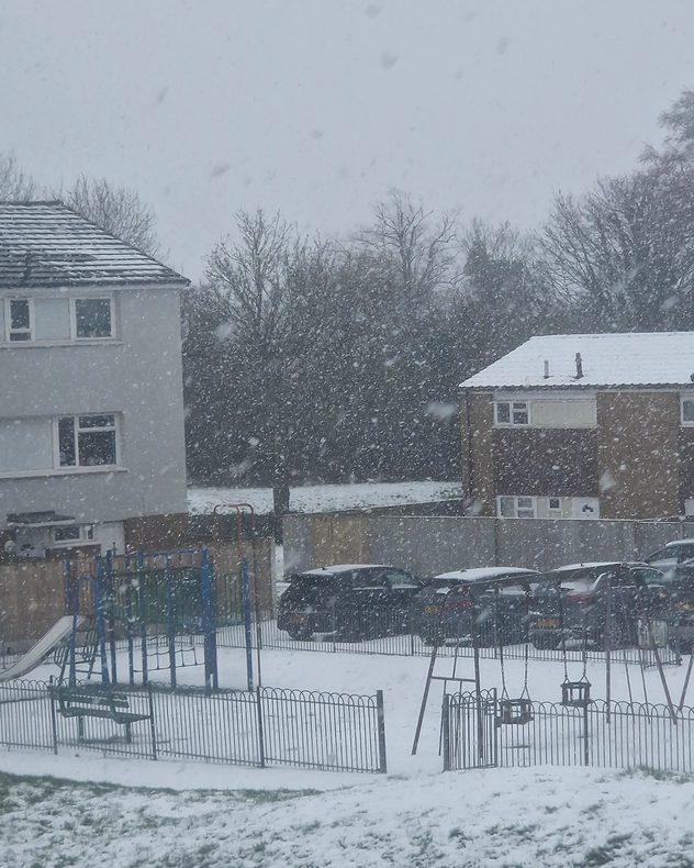
Heavy snow falling over a residential area with houses, parked cars, and a small fenced playground, as large snowflakes reduce visibility and coat roofs, trees, and the ground.
Snow-covered beach and promenade at night with a row of colorful beach huts, footprints in the snow, calm sea on the horizon, and a clear dark blue sky dotted with stars.
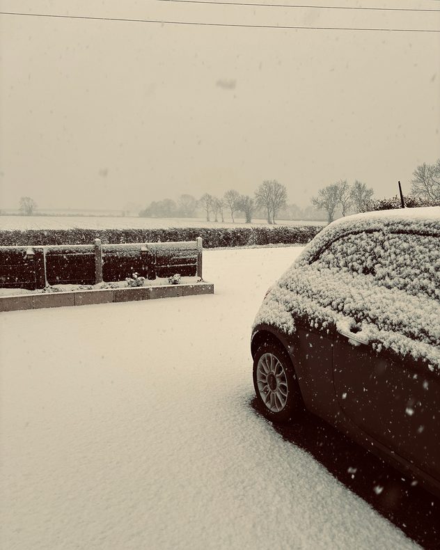
Snow falling steadily onto a parked car and driveway, with fresh snow covering the ground, hedges, and distant trees in a flat rural landscape under a pale overcast sky.
Bright full moon surrounded by a soft circular halo in a dark, hazy night sky, with faint stars visible and silhouettes of distant trees, rooftops, and utility poles along the horizon.
1/5
Fresh snow and blue skies in Lowestoft, Suffolk. - © Elaine High

Storm Goretti capped a cold, snowy week across the UK and Ireland. As always, caught on camera by you!

As winter takes a full grip, don't forget to send in your own shots for next week's collection and to appear on our social channels.

Just tap the image icon in the app, or use the uploaders for the UK or Ireland here.

Get involved! Using the Uploaderread more
Weather & Radar editorial team
More on the topic
Chance of thundery showers breaking out. Over the coming days. . . Tuesday, 18 August 2026
Split weather graphic showing a yellow thunderstorm warning across eastern England alongside radar with heavy showers and lightning near Sheffield, Leicester and East Anglia.
Tuesday, 18 August 2026

Over the coming days

Chance of thundery showers breaking out
Damage in Germany after severe weather. Several tornadoes formed. . . Thursday, 20 August 2026
Split image: Weather map showing thunderstorms and a tornado symbol over western Germany. On the right, severe damage to buildings and rubble on a road can be seen.
Thursday, 20 August 2026

Several tornadoes formed

Damage in Germany after severe weather
Severe weather risk in holiday spots. Hail and heavy rain. . . Wednesday, 19 August 2026
Split weather graphic showing intense thunderstorms and widespread lightning across northern Italy and Switzerland on the left, with severe warning zones from yellow to red around Milan and the southern Alps on the right.
Wednesday, 19 August 2026

Hail and heavy rain

Severe weather risk in holiday spots
All weather news
This might also interest you
Turbulent weather in the Canary Islands. Storm and rain. . . Friday, 12 December 2025
Weather graphic showing rain and wind fields over the Canary Islands and a central warning symbol.
Friday, 12 December 2025

Storm and rain

Turbulent weather in the Canary Islands
Super Typhoon Bavi threatens Taiwan. Up to 1,000 mm of rain. . . Wednesday, 8 July 2026
The image shows an intense tropical cyclone over the western Pacific, east of Taiwan and the Philippines. The centre of the system is depicted as a light purple and white vortex with a clearly visible eye, surrounded by a ring of red and orange areas indicating the strongest wind speeds. A white arrow marks the typhoon’s predicted track towards the north-west, in the direction of Taiwan. To the west of the storm lie the Philippines, with the cities of Manila and Cebu; to the north of these lies Taiwan, with Taipei. Further west, the Chinese coast, including Hong Kong, and parts of Vietnam can be seen. The coloured wind map shows predominantly green areas outside the storm’s core, indicating significantly weaker winds. White streamlines illustrate the typhoon’s anti-clockwise circulation in the Northern Hemisphere. The highest wind speeds are concentrated around the eye of the cyclone.
Wednesday, 8 July 2026

Up to 1,000 mm of rain

Super Typhoon Bavi threatens Taiwan
Historic Storm Éowyn arrives. On this day.... . . Saturday, 24 January 2026
Split image showing a person in a yellow jacket struggling against strong winds and heavy rain on a street at night on the left, and an Irish wind forecast map on the right with red and purple shading, gusts up to 75 mph, and a wind warning icon, divided by a curved white line.
Saturday, 24 January 2026

On this day...

Historic Storm Éowyn arrives
All articles
Weather & Radar

Weather & Radar is also available on

Google Play StoreApp Store

Company

Contact us Privacy Policy Legal info Accessibility statement

Services

Uploader

Socials

facebooktwittertikToklinkList